Country:
Region:
City:
Latitude and Longitude:
Time Zone:
Postal Code:
IP information under different IP Channel
ip-api
Country
Region
City
ASN
Time Zone
ISP
Blacklist
Proxy
Latitude
Longitude
Postal
Route
Luminati
Country
Region
rp
City
kaiserslautern
ASN
Time Zone
Europe/Berlin
ISP
VSE NET GmbH
Latitude
Longitude
Postal
IPinfo
Country
Region
City
ASN
Time Zone
ISP
Blacklist
Proxy
Latitude
Longitude
Postal
Route
db-ip
Country
Region
City
ASN
Time Zone
ISP
Blacklist
Proxy
Latitude
Longitude
Postal
Route
ipdata
Country
Region
City
ASN
Time Zone
ISP
Blacklist
Proxy
Latitude
Longitude
Postal
Route
Popular places and events near this IP address

Palatinate (region)
Historical region of Germany
Distance: Approx. 5082 meters
Latitude and longitude: 49.43333333,7.76666667
The Palatinate (German: Pfalz; Palatine German: Palz), or the Rhenish Palatinate (Rheinpfalz), is a historical region of Germany. The Palatinate occupies most of the southern quarter of the German federal state of Rhineland-Palatinate (Rheinland-Pfalz), covering an area of 2,105 square miles (5,450 km2) with about 1.4 million inhabitants. Its residents are known as Palatines (Pfälzer).

Kaiserslautern
Town in Rhineland-Palatinate, Germany
Distance: Approx. 5967 meters
Latitude and longitude: 49.44472222,7.76888889
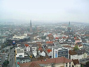
Kaiserslautern (German pronunciation: [ˌkaɪzɐsˈlaʊtɐn] ; Palatinate German: Lautre) is a town in southwest Germany, located in the state of Rhineland-Palatinate at the edge of the Palatinate Forest. The historic centre dates to the 9th century. It is 459 kilometres (285 miles) from Paris, 117 km (73 miles) from Frankfurt am Main, 666 kilometers (414 miles) from Berlin, and 159 km (99 miles) from Luxembourg.

Technical University of Kaiserslautern
Distance: Approx. 3711 meters
Latitude and longitude: 49.42388889,7.75305556
Technical University of Kaiserslautern (German: Technische Universität Kaiserslautern, also known as TU Kaiserslautern or TUK) was a public research university in Kaiserslautern, Germany. On January 1, 2023, the university was merged with the Landau campus of the University of Koblenz-Landau into the University of Kaiserslautern-Landau, or Rheinland-Pfälzische Technische Universität Kaiserslautern-Landau (RPTU) in German. There are numerous institutes around the university, including two Fraunhofer Institutes (IESE and ITWM), the Max Planck Institute for Software Systems (MPI SWS), the German Research Center for Artificial Intelligence (DFKI), the Institute for Composite Materials (IVW) and the Institute for Surface and Thin Film Analysis (IFOS), all of which cooperate closely with the university.

Humberg (Kaiserslautern)
Distance: Approx. 4417 meters
Latitude and longitude: 49.413332,7.767591
The Humberg is a mountain in the south of Kaiserslautern, Germany, that stands on the border of the Palatinate forest. With a height of 425 meters, it is the highest point in the area of Kaiserslautern. At its peak, the Humberg Tower (German: Humbergturm) provides a dramatic view of the area below.

German Research Centre for Artificial Intelligence
Nonprofit contract research institute
Distance: Approx. 3952 meters
Latitude and longitude: 49.42944444,7.75194444
The German Research Center for Artificial Intelligence, DFKI (German: Deutsches Forschungszentrum für Künstliche Intelligenz) was founded in 1988 as a non-profit public-private partnership. It has research facilities in Kaiserslautern, Saarbrücken, Bremen, Oldenburg, and Osnabrück, laboratories in Berlin, Darmstadt, and Lübeck, and a branch office in Trier. In the field of innovative commercial software technology using artificial intelligence, DFKI is the leading research center in Germany.

Kindsbach
Municipality in Rhineland-Palatinate, Germany
Distance: Approx. 5460 meters
Latitude and longitude: 49.41833333,7.63277778
Kindsbach is a municipality in the district of Kaiserslautern, in Rhineland-Palatinate, western Germany.

Krickenbach
Municipality in Rhineland-Palatinate, Germany
Distance: Approx. 5776 meters
Latitude and longitude: 49.36388889,7.66861111
Krickenbach is a municipality in the district of Kaiserslautern, in Rhineland-Palatinate, western Germany.

Stelzenberg
Municipality in Rhineland-Palatinate, Germany
Distance: Approx. 4105 meters
Latitude and longitude: 49.38,7.74111111
Stelzenberg is a municipality in the district of Kaiserslautern, in Rhineland-Palatinate, western Germany.

Humberg Tower
Distance: Approx. 5331 meters
Latitude and longitude: 49.415,7.78
The Humberg Tower is an observation tower on the Humberg hill, 425 metres (1,400 feet) high, to the south of the city of Kaiserslautern in southwest Germany. The idea of building a tower on the Humberg (already in those days a favourite hill among the citizens of Kaiserslautern, for its view) was taken up in 1896. For this purpose, inhabitants of the city founded the Humberg Association, with the aim of financing the building of an observation tower.

Hohenecken Castle
Distance: Approx. 716 meters
Latitude and longitude: 49.4147,7.7013
Hohenecken Castle (German: Burg Hohenecken) (MHG: buorch hônecke) is the ruin of a spur castle from the Hohenstaufen era on the Schlossberg hill above the Kaiserslautern ward of Hohenecken in Rhineland-Palatinate, Germany. It is located at an elevation of 363 m above sea level (NN).

Schopp station
Railway station in Schopp, Germany
Distance: Approx. 5777 meters
Latitude and longitude: 49.35905,7.68757
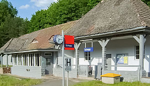
Schopp station is a station in the village of Schopp in the German state of Rhineland-Palatinate. Deutsche Bahn classifies it as a category 6 station and it has two platform tracks. The station is located in the network of the Verkehrsverbund Rhein-Neckar (Rhine-Neckar transport association, VRN) and belongs to fare zone 824.

University of Kaiserslautern-Landau
Distance: Approx. 3711 meters
Latitude and longitude: 49.42388889,7.75305556
The University of Kaiserslautern-Landau (German: Rheinland-Pfälzische Technische Universität Kaiserslautern-Landau, also known as RPTU) is a public research university in Kaiserslautern and Landau in der Pfalz, Germany. The university was formed by the merger of the Technical University of Kaiserslautern and the Landau campus of the University of Koblenz and Landau on January 1, 2023. There are numerous institutes around the university, including two Fraunhofer Institutes (IESE and ITWM), the Max Planck Institute for Software Systems (MPI-SWS), the German Research Center for Artificial Intelligence (DFKI), the Institute for Composite Materials (IVW) and the Institute for Surface and Thin Film Analysis (IFOS), all of which cooperate closely with the university.
Weather in this IP's area
light rain
4 Celsius
4 Celsius
3 Celsius
6 Celsius
1029 hPa
98 %
1029 hPa
982 hPa
5000 meters
100 %
07:38:57
16:48:34