Country:
 Netherlands
Region:
City:
Latitude and Longitude:
Time Zone:
Postal Code:
IP information under different IP Channel
ip-api
Country
Region
City
ASN
Time Zone
ISP
Blacklist
Proxy
Latitude
Longitude
Postal
Route
IPinfo
Country
Region
City
ASN
Time Zone
ISP
Blacklist
Proxy
Latitude
Longitude
Postal
Route
MaxMind
Country
Region
City
ASN
Time Zone
ISP
Blacklist
Proxy
Latitude
Longitude
Postal
Route
Luminati
Country
NLASN
Time Zone
Europe/Amsterdam
ISP
The Internet Engineering Group B.V.
Latitude
Longitude
Postal
db-ip
Country
Region
City
ASN
Time Zone
ISP
Blacklist
Proxy
Latitude
Longitude
Postal
Route
ipdata
Country
Region
City
ASN
Time Zone
ISP
Blacklist
Proxy
Latitude
Longitude
Postal
Route
Popular places and events near this IP address

Ede, Netherlands
Town and municipality in Gelderland, Netherlands
Distance: Approx. 3218 meters
Latitude and longitude: 52.05,5.66666667
Ede (Dutch pronunciation: [ˈeːdə] ) is a town and municipality in the Netherlands, in the province of Gelderland. As of 1 July 2021, Ede had 119,186 inhabitants.

De Klomp
Village in Gelderland, Netherlands
Distance: Approx. 3898 meters
Latitude and longitude: 52.04444444,5.57166667
De Klomp is a village in the municipality of Ede, with a railway station called "Veenendaal-De Klomp railway station". It is located in the Dutch province of Gelderland. It was first mentioned in 1787 as De Klomp, and is a name of an inn.

Groenhorst College
Distance: Approx. 3086 meters
Latitude and longitude: 52.01833333,5.6625
Groenhorst College is an education centre that has 11 locations in the centre of Netherlands: Almere, Barneveld, Bilthoven, Dronten, Ede (2 locations, including the management), Emmeloord (2 locations), Lelystad, Maartensdijk, Nijkerk and Velp. It offers several 'green' high school programmes, apprenticeship programmes on nutrition and nature & environment, education for adults, and several courses.

Ede-Wageningen railway station
Railway station in the Netherlands
Distance: Approx. 3215 meters
Latitude and longitude: 52.02777778,5.67194444
Ede-Wageningen is a railway station located in Ede, Netherlands. It is situated on the Amsterdam–Arnhem railway and the Nijkerk–Ede-Wageningen railway. The station is the main Intercity station, but is not in the centre of the town.

Ede Centrum railway station
Railway station in the Netherlands
Distance: Approx. 2984 meters
Latitude and longitude: 52.04305556,5.66805556
Ede Centrum is a railway station located in Ede, Netherlands. The station was opened on 1 May 1902 and is located on the Nijkerk–Ede-Wageningen railway. The station closed on 7 September 1944 and re-opened 20 May 1951.

Ede Christian University of Applied Sciences
University in The Netherlands
Distance: Approx. 3091 meters
Latitude and longitude: 52.01972222,5.66416667
Ede Christian University of Applied Sciences (Dutch: Christelijke Hogeschool Ede; Dutch abbreviation: CHE) is a Christian vocational university located in Ede, Netherlands. The CHE has a clear Christian basis: the Bible as norm and source of inspiration. From 2004-2011 and in 2015, 2016 and 2017, the CHE was appointed for the eleventh time as the best university of applied sciences in the Netherlands.
Veenendaal-De Klomp railway station
Railway station in the Netherlands
Distance: Approx. 3798 meters
Latitude and longitude: 52.04583333,5.57388889
Veenendaal-De Klomp is a railway station located in De Klomp near Veenendaal, Netherlands. The station opened in 1845 and is on the Amsterdam–Arnhem railway. It lies within the borders of the municipality of Ede.
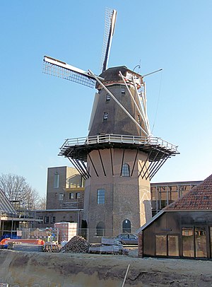
Concordia, Ede
Dutch windmill
Distance: Approx. 3001 meters
Latitude and longitude: 52.04690833,5.66580833
Concordia is a smock mill in Ede, the Netherlands, which is maintained in working order. The mill is listed as Rijksmonument number 14469.

Doesburgermolen
Dutch windmill
Distance: Approx. 3377 meters
Latitude and longitude: 52.06205556,5.64880556
The Doesburgermolen is a post mill in the hamlet of Doesburgerbuurt in the community of Ede, Netherlands It is considered to be the oldest post mill in the Netherlands; in its present form it was probably built around 1630. It underwent a major restoration around 1970. The mill is operated by volunteers and is still used for grinding grain.

De Keetmolen, Ede
Dutch windmill
Distance: Approx. 3066 meters
Latitude and longitude: 52.02974,5.67043
De Keetmolen (The Shack Mill) is a windmill in Ede, Netherlands. According to the inscription under the sails and the sign at the entrance, the mill was built in 1750. This is incorrect; according to municipal records, the building permit issued in 1856 stated that the mill should be built within two years.
Edese Zwem- & Poloclub Polar Bears
Dutch water polo club
Distance: Approx. 902 meters
Latitude and longitude: 52.0358,5.6396
Edese Zwem- & Poloclub Polar Bears, or simply Polar Bears Ede, is a swimming and water polo club based in the city of Ede, Netherlands.
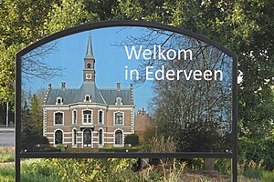
Ederveen
Village in Gelderland, Netherlands
Distance: Approx. 4599 meters
Latitude and longitude: 52.06666667,5.58333333
Ederveen is a village in the municipality of Ede in the province of Gelderland, the Netherlands.
Weather in this IP's area
scattered clouds
22 Celsius
21 Celsius
20 Celsius
23 Celsius
1007 hPa
53 %
1007 hPa
1005 hPa
10000 meters
5.14 m/s
180 degree
40 %
07:01:15
20:09:17