185.119.238.236 - IP Lookup: Free IP Address Lookup, Postal Code Lookup, IP Location Lookup, IP ASN, Public IP
Country:
 Spain
SpainRegion:
City:
Location:
Time Zone:
Postal Code:
ISP:
ASN:
language:
User-Agent:
Proxy IP:
Blacklist:
IP information under different IP Channel
ip-api
Country
Region
City
ASN
Time Zone
ISP
Blacklist
Proxy
Latitude
Longitude
Postal
Route
db-ip
Country
Region
City
ASN
Time Zone
ISP
Blacklist
Proxy
Latitude
Longitude
Postal
Route
IPinfo
Country
Region
City
ASN
Time Zone
ISP
Blacklist
Proxy
Latitude
Longitude
Postal
Route
IP2Location
185.119.238.236Country
esRegion
castilla-la mancha
City
toledo
Time Zone
Europe/Madrid
ISP
Language
User-Agent
Latitude
Longitude
Postal
ipdata
Country
Region
City
ASN
Time Zone
ISP
Blacklist
Proxy
Latitude
Longitude
Postal
Route
Popular places and events near this IP address

Roman Catholic Archdiocese of Toledo
Roman Catholic archdiocese in Spain
Distance: Approx. 75 meters
Latitude and longitude: 39.8575,-4.0231
The Archdiocese of Toledo (Latin: Archidioecesis Metropolitae Toletana) is a Latin Church archdiocese of the Catholic Church located in Spain. They are also the Primates of Spain. It was, according to tradition established in the 1st century by James the Great and was elevated to an archdiocese in 313 after the Edict of Milan.

Siege of the Alcázar
Nationalist victory in Toledo (1936) at the opening stages of the Spanish Civil War
Distance: Approx. 180 meters
Latitude and longitude: 39.8582,-4.0206
The siege of the Alcázar was a highly symbolic Nationalist victory in Toledo in the opening stages of the Spanish Civil War. The Alcázar of Toledo was held by a variety of military forces in favour of the Nationalist uprising. Militias of the parties in the Popular Front began their siege on July 21, 1936.

Alcázar of Toledo
Fortress in Toledo, Spain
Distance: Approx. 177 meters
Latitude and longitude: 39.858084,-4.020631
The Alcázar of Toledo (Spanish: Alcázar de Toledo, IPA: [alˈkaθaɾ ðe toˈleðo]) is a stone fortification located in the highest part of Toledo, Spain. It is a large quadrangular building measuring 60 meters on a side, framed by four large towers 60 meters high, each crowned by the typical Madrid spire. Most of the building was rebuilt between 1939 and 1957 after the siege of the Alcázar during the Spanish Civil War.

Mosque of las Tornerías
Former mosque in Toledo, Spain
Distance: Approx. 45 meters
Latitude and longitude: 39.8585,-4.0228
The Mosque of las Tornerías (Spanish: Mezquita de las Tornerías; Arabic: al-Mustimim) is a former mosque in Toledo, in the Castile-La Mancha of Spain. The former Moorish-style mosque was built in the middle of the 11th century on the foundations of Roman architecture, located in the old Muslim neighborhood Arrabal de Francos. Currently it houses the "Center Foundation of Promotion of the Crafts", that can be visited and hosts temporary exhibitions.
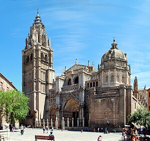
Toledo Cathedral
Seat of Archdiocese of Toledo, Spain
Distance: Approx. 152 meters
Latitude and longitude: 39.85708333,-4.02388889
The Primatial Cathedral of Saint Mary of Toledo (Spanish: Catedral Primada Santa María de Toledo), otherwise known as Toledo Cathedral, is a Catholic church in Toledo, Spain. It is the seat of the Metropolitan Archdiocese of Toledo. The cathedral of Toledo is one of the three 13th-century High Gothic cathedrals in Spain and is considered, in the opinion of some authorities, to be the magnum opus of the Gothic style in Spain.

Archbishop's Palace of Toledo
Distance: Approx. 208 meters
Latitude and longitude: 39.8573,-4.0249
The Palacio Arzobispal de Toledo or Archbishop's Palace of Toledo is a palace located in front of the Cathedral and next to the City Hall in the city of Toledo, region of Castile-La Mancha, Spain. It was built on land donated to the church by Jose Manuel Thotocopuli, son of El Greco. The palace was constructed over centuries.
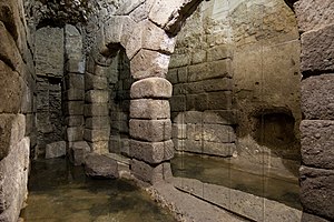
Cave of Hercules
Subterranean vaulted space in Toledo, Spain
Distance: Approx. 156 meters
Latitude and longitude: 39.8586,-4.0244
The Cave of Hercules (Spanish: Cueva de Hércules) is a subterranean vaulted space dating back to Roman times located in the alley of San Ginés (Spanish: Callejón San Ginés) in the city of Toledo, Spain. The cave is under a building located where the Church of San Ginés, Toledo stood until 1841.

Teatro Rojas
Distance: Approx. 34 meters
Latitude and longitude: 39.8578,-4.0226
The Teatro Rojas is a theater in the city of Toledo, Castile-La Mancha, Spain, inaugurated in 1879 on the site of the old corral de comedias, Mesón de la Fruta. Its construction involved several architects, and it is named after the local playwright Francisco de Rojas.

Former Casino of Toledo
Distance: Approx. 108 meters
Latitude and longitude: 39.8587,-4.0217
The building of the former Casino of Toledo (Spain), whose real name corresponds to the one of Center of Artists and Industrialists, belongs to the trend of Eclecticism that develops In Europe in the 19th century. The architect, Felipe Trigo, mixed elements of the Renaissance, in the configuration and planning of the facade, and Mudéjar, in the use of the brick. The building, whose plant is a quadrilateral, has four floors and a tower; the latter form chamfered corner and houses the main entrance.

Iglesia de las Santas Justa y Rufina, Toledo
Distance: Approx. 103 meters
Latitude and longitude: 39.8589,-4.0233
The Iglesia de las Santas Justa y Rufina is a medieval church in Toledo, Castile-La Mancha, Spain. It is one of a group of so-called Mozarabic parish churches in Toledo, whose existence has been documented since 1156. However, certain material remains reveal the existence in this place of an Islamic construction, which would undoubtedly have to be identified with a mosque.

Museum of the Army (Toledo)
Military museum in Toledo, Spain
Distance: Approx. 200 meters
Latitude and longitude: 39.8587,-4.0205
The Museum of the Army (Spanish: Museo del Ejército) is a military museum in Toledo, Spain, devoted to the history of the Spanish Army. It is one of the National Museums of Spain and it is attached to the Ministry of Defence. The collection was previously housed in Madrid, and the museum opened on its present site in 2010.

Plaza de Zocodover, Toledo
Public square in Toledo
Distance: Approx. 196 meters
Latitude and longitude: 39.85952222,-4.02135278
The Plaza de Zocodover is a square in the city of Toledo, in the autonomous community of Castile-La Mancha, Spain. It was the central hub of the city during most of its history, acting as its main square. Part of it was designed by Juan de Herrera during the reign of Philip II. Horses, donkeys, foals, mares, mules and other animals were sold in the square when Toledo was a Spanish-Muslim city.
Weather in this IP's area
overcast clouds
7 Celsius
6 Celsius
7 Celsius
7 Celsius
1019 hPa
90 %
1019 hPa
948 hPa
10000 meters
2.67 m/s
6.05 m/s
250 degree
100 %