Country:
 France
Region:
City:
Latitude and Longitude:
Time Zone:
Postal Code:
IP information under different IP Channel
ip-api
Country
Region
City
ASN
Time Zone
ISP
Blacklist
Proxy
Latitude
Longitude
Postal
Route
IPinfo
Country
Region
City
ASN
Time Zone
ISP
Blacklist
Proxy
Latitude
Longitude
Postal
Route
MaxMind
Country
Region
City
ASN
Time Zone
ISP
Blacklist
Proxy
Latitude
Longitude
Postal
Route
Luminati
Country
FRRegion
ara
City
grenoble
ASN
Time Zone
Europe/Paris
ISP
Nomotech SAS
Latitude
Longitude
Postal
db-ip
Country
Region
City
ASN
Time Zone
ISP
Blacklist
Proxy
Latitude
Longitude
Postal
Route
ipdata
Country
Region
City
ASN
Time Zone
ISP
Blacklist
Proxy
Latitude
Longitude
Postal
Route
Popular places and events near this IP address
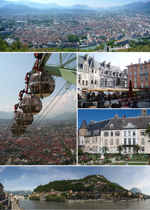
Grenoble
Prefecture and commune in Auvergne-Rhône-Alpes, France
Distance: Approx. 582 meters
Latitude and longitude: 45.171546,5.722387
Grenoble ( grə-NOH-bəl; French: [ɡʁənɔbl] ; Arpitan: Grenoblo or Grainóvol; Occitan: Graçanòbol) is the prefecture and largest city of the Isère department in the Auvergne-Rhône-Alpes region of southeastern France. It was the capital of the Dauphiné historical province and lies where the river Drac flows into the Isère at the foot of the French Alps. The population of the commune of Grenoble was 158,198 as of 2019, while the population of the Grenoble metropolitan area (French: aire d'attraction de Grenoble or agglomération grenobloise) was 714,799 which makes it the largest metropolis in the Alps, ahead of Innsbruck and Bolzano.

Arrondissement of Grenoble
Arrondissement in Auvergne-Rhône-Alpes, France
Distance: Approx. 412 meters
Latitude and longitude: 45.18027778,5.72111111
The arrondissement of Grenoble is an arrondissement of France in the Isère department in the Auvergne-Rhône-Alpes region. It has 263 communes. Its population is 738,149 (2016), and its area is 4,398.7 km2 (1,698.3 sq mi).

Stade Lesdiguières
Distance: Approx. 1455 meters
Latitude and longitude: 45.16611111,5.70944444
Stade Lesdiguières is a multi-purpose stadium in Grenoble, France. The stadium holds 12,000 spectators (8,500 seated). It is the home of the FC Grenoble rugby union club.
Grenoble-Alpes Métropole
Métropole in Auvergne-Rhône-Alpes, France
Distance: Approx. 1492 meters
Latitude and longitude: 45.19,5.72
Grenoble-Alpes Métropole is the métropole, an intercommunal structure, centred on the city of Grenoble. It is located in the Isère department, in the Auvergne-Rhône-Alpes region, eastern France. It was created in January 2015, replacing the previous Communauté d'agglomération de Grenoble.

École supérieure d'Art de Grenoble
School of Fine Arts in France
Distance: Approx. 1221 meters
Latitude and longitude: 45.18666667,5.72666667
École supérieure d'Art de Grenoble is a school of Fine Arts in Grenoble, France.
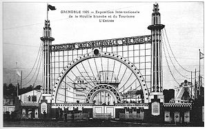
International Exhibition of Hydropower and Tourism
Distance: Approx. 1470 meters
Latitude and longitude: 45.18472,5.73528
The International Exhibition of Hydropower and Tourism (French: Exposition internationale de la houille blanche et du tourisme) was an exhibition which ran from May 21 to October 25, 1925, in the city of Grenoble in France, in order to promote the city as the capital of "white coal" (houille blanche), as hydropower was then known. This exhibition gave credit to the people of Grenoble in general, and the industrialist Aristide Bergès in particular, for harnessing the driving force of water rushing down from the mountains. This was also an opportunity for Grenoble to celebrate the new industries of tomorrow.

Bibliothèque municipale de Grenoble
Distance: Approx. 1275 meters
Latitude and longitude: 45.18527778,5.73111111
The Bibliothèque municipale de Grenoble is a library in Grenoble, France. It was founded in 1772, following the succession of Bishop, Jean de Caulet. The current building located Boulevard Maréchal Lyautey was opened in January 1960 for the University and since 1970, for all audiences.
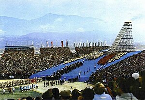
Olympic Stadium (Grenoble)
Distance: Approx. 1511 meters
Latitude and longitude: 45.16583333,5.73222222
Olympic Stadium, also known as Opening Stadium, was a temporary stadium in Grenoble, France. Built to only host the opening ceremonies for the 1968 Winter Olympics, the stadium was immediately disassembled following the games. The stadium held 60,000 spectators.

Conservatoire de Grenoble
Distance: Approx. 1173 meters
Latitude and longitude: 45.1733,5.7347
The Conservatoire de Grenoble, in French Conservatoire à rayonnement régional de Grenoble is a Chartered artistic institution controlled by the Ministry of Culture and Communication, represented by the Regional Directorate of cultural Affairs (DRAC). The conservatory is located at 6, Chemin de Gordes 38100 Grenoble, France. The institute offers three specialties, music, dance and drama.
Lycée Vaucanson (Grenoble)
Senior high school in Grenoble, France
Distance: Approx. 1163 meters
Latitude and longitude: 45.1711,5.7079
Lycée Vaucanson is a senior high school/sixth-form college in Grenoble, France. It originated from the Petit Séminaire du Rondeau, established in 1815, and the Ecole Supérieur, established in 1836. The institution took the name Ecole Professionnelle Vaucanson in 1876 in honor of the French inventor Jacques de Vaucanson.
Canton of Grenoble-4
Distance: Approx. 381 meters
Latitude and longitude: 45.18,5.72
The canton of Grenoble-4 is an administrative division of the Isère department, eastern France. Its borders were modified at the French canton reorganisation which came into effect in March 2015. Its seat is in Grenoble.
École nationale supérieure de génie industriel
French engineering College
Distance: Approx. 1492 meters
Latitude and longitude: 45.19,5.72
École nationale supérieure de génie industriel (ENSGI) a French engineering College created in 1990. In addition to its main industrial engineering training, the school hosts a training course for engineers in technological management conducted in partnership with Grenoble School of Management. Located in Grenoble, the ENSGI is a public higher education institution.
Weather in this IP's area
overcast clouds
15 Celsius
15 Celsius
13 Celsius
16 Celsius
1012 hPa
96 %
1012 hPa
987 hPa
10000 meters
0.45 m/s
1.34 m/s
208 degree
100 %
07:57:05
18:47:00