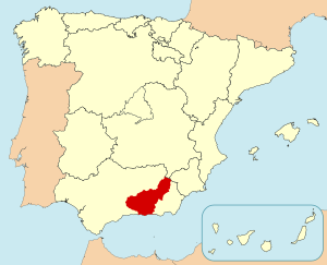
Country:
 Spain
SpainRegion:
City:
Latitude and Longitude:
Time Zone:
Postal Code:
IP information under different IP Channel
ip-api
Country
Region
City
ASN
Time Zone
ISP
Blacklist
Proxy
Latitude
Longitude
Postal
Route
IPinfo
Country
Region
City
ASN
Time Zone
ISP
Blacklist
Proxy
Latitude
Longitude
Postal
Route
MaxMind
Country
Region
City
ASN
Time Zone
ISP
Blacklist
Proxy
Latitude
Longitude
Postal
Route
Luminati
Country
ESRegion
an
City
granada
ASN
Time Zone
Europe/Madrid
ISP
Iberwix Telecom S.l.
Latitude
Longitude
Postal
db-ip
Country
Region
City
ASN
Time Zone
ISP
Blacklist
Proxy
Latitude
Longitude
Postal
Route
ipdata
Country
Region
City
ASN
Time Zone
ISP
Blacklist
Proxy
Latitude
Longitude
Postal
Route
Popular places and events near this IP address

Granada
Municipality in Andalusia, Spain
Distance: Approx. 1712 meters
Latitude and longitude: 37.17805556,-3.60083333
Granada ( grə-NAH-də; Spanish: [ɡɾaˈnaða] , locally [ɡɾaˈna]) is the capital city of the province of Granada, in the autonomous community of Andalusia, Spain. Granada is located at the foot of the Sierra Nevada mountains, at the confluence of four rivers, the Darro, the Genil, the Monachil and the Beiro. Ascribed to the Vega de Granada comarca, the city sits at an average elevation of 738 m (2,421 ft) above sea level, yet is only one hour by car from the Mediterranean coast, the Costa Tropical.

Vega de Granada
Comarca in Andalusia, Spain
Distance: Approx. 493 meters
Latitude and longitude: 37.1875,-3.61083333
The Vega de Granada is a comarca (county, but with no administrative role) in the province of Granada, southeastern Spain. The name refers to the plain near the city of Granada. According to the 2007 census (INE), the comarca had a population of 500,121 inhabitants, which is over half the overall population of the province.

Monasterio de San Jerónimo, Granada
Distance: Approx. 1492 meters
Latitude and longitude: 37.17916667,-3.60388889
The Royal Monastery of St. Jerome (Spanish: Real Monasterio de San Jerónimo de Granada) is a Roman Catholic Hieronymite monastery in Granada, Spain. Architecturally, it is in the Renaissance style.
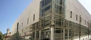
Granada Public Library
Library in Spain
Distance: Approx. 1533 meters
Latitude and longitude: 37.178282,-3.606195
The Granada Public Library is a public library located in Granada, Spain.
Andalusian School of Public Health
Public institution
Distance: Approx. 1384 meters
Latitude and longitude: 37.19017,-3.59403
The Andalusian School of Public Health (Spanish language acronym: EASP) is a public institution which provides training, consultancy and research services for the healthcare sector. It is located in Granada (Spain), on the University campus. It is a state-owned enterprise, promoted by the Andalusian government.

Gate of Elvira
Historic site in Granada, Spain
Distance: Approx. 1344 meters
Latitude and longitude: 37.18222222,-3.60027778
The Gate of Elvira (Spanish: Puerta de Elvira) is an arch located in Granada, Spain. It was declared Bien de Interés Cultural in 1896. It is located at the beginning of Calle Elvira (Elvira Street), on the edge of the Albaicín neighbourhood.
Granada (wine)
Spanish Denominación de Origen Protegida for wines in the province of Granada, Andalusia, Spain
Distance: Approx. 1232 meters
Latitude and longitude: 37.18333333,-3.60055556
Granada is a Spanish Denominación de Origen Protegida (DOP) for wines in the province of Granada, Andalusia, Spain, extending over 168 different municipalities. There is also sub-zone known as "Contraviesa-Alpujarras", covering another 13 municipalities in the Alpujarras mountains. Granada achieved Vino de Calidad status in 2009, and Denominación de Origen status in 2018.

San Juan de Dios Hospital (Granada)
Hospital in Granada, Spain
Distance: Approx. 1402 meters
Latitude and longitude: 37.180315,-3.603014
San Juan de Dios Hospital is an institution in the Spanish city of Granada, situated next to the Basílica de San Juan de Dios It was founded by John of God (Juan de Dios in Spanish), a soldier turned healthcare worker. The site is now in the city centre, but when the hospital was founded it was outside the medieval walled city. The saint's followers formed the Brothers Hospitallers of Saint John of God, who ran this hospital and maintained from its origin the dedication to healthcare for the most disadvantaged people.
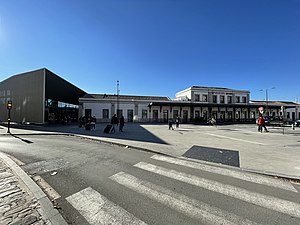
Granada railway station
Main railway station of Granada
Distance: Approx. 905 meters
Latitude and longitude: 37.1837,-3.6086
Granada railway station is the main railway station of the Spanish city of Granada, Andalusia. The building dates back to the 1874, but the facilities have been modernised over the years, most notably to accommodate AVE high-speed trains.

Dar al-Horra
Distance: Approx. 1638 meters
Latitude and longitude: 37.1815,-3.59630556
Dar al-Horra (Arabic: دار الحرة; Spanish: Palacio de Dar al-Horra) is a former 15th-century Nasrid palace located in the Albaicín quarter of Granada, Spain. Since the early 16th century it was used as part of the Monastery of Santa Isabel la Real. It is now a historic monument.

Aljibe del Rey
Cistern (aljibe) in Granada, Spain
Distance: Approx. 1691 meters
Latitude and longitude: 37.181656,-3.595314
The Aljibe del Rey (the King's Cistern) in the Albaicín district in Granada, Spain is a cistern dating from the 10/11th centuries. Built by the Nasrid rulers to provide water to their palace complex, al-Qaṣaba al-Qadīma, it is the largest cistern in the district. The aljibe is now managed by the AguaGranada Foundation and the attached carmen (house) contains an interpretation centre.

Church of San Miguel Bajo
Church in Granada, Spain
Distance: Approx. 1691 meters
Latitude and longitude: 37.181656,-3.595314
The Church of San Miguel Bajo (Spanish: Iglesia de La Aurora y San Miguel Bajo) is a church and historic monument in Granada, Spain. The church is located in the historic Albaicín neighbourhood, at Placeta de San Miguel Bajo. It was built in the 16th century on the site of the neighbourhood's former main mosque and incorporates an element of its remains.
Weather in this IP's area
clear sky
15 Celsius
15 Celsius
13 Celsius
15 Celsius
1023 hPa
68 %
1023 hPa
943 hPa
10000 meters
2.06 m/s
360 degree
08:26:06
19:32:16