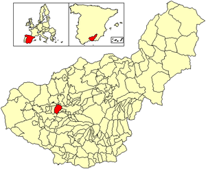
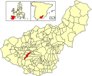
Country:
 Spain
SpainRegion:
City:
Latitude and Longitude:
Time Zone:
Postal Code:
IP information under different IP Channel
ip-api
Country
Region
City
ASN
Time Zone
ISP
Blacklist
Proxy
Latitude
Longitude
Postal
Route
IPinfo
Country
Region
City
ASN
Time Zone
ISP
Blacklist
Proxy
Latitude
Longitude
Postal
Route
MaxMind
Country
Region
City
ASN
Time Zone
ISP
Blacklist
Proxy
Latitude
Longitude
Postal
Route
Luminati
Country
ESRegion
an
City
hijar
ASN
Time Zone
Europe/Madrid
ISP
Iberwix Telecom S.l.
Latitude
Longitude
Postal
db-ip
Country
Region
City
ASN
Time Zone
ISP
Blacklist
Proxy
Latitude
Longitude
Postal
Route
ipdata
Country
Region
City
ASN
Time Zone
ISP
Blacklist
Proxy
Latitude
Longitude
Postal
Route
Popular places and events near this IP address
Santa Fe, Granada
Municipality in Andalusia, Spain
Distance: Approx. 6225 meters
Latitude and longitude: 37.18916667,-3.71777778
Santa Fe is a Spanish municipality in the province of Granada, situated in the Vega de Granada, irrigated by the river Genil. The town was originally built by the Catholic armies besieging Granada (c. 1490) after a fire destroyed much of their encampment.

Park Federico García Lorca
Park in Spain
Distance: Approx. 6813 meters
Latitude and longitude: 37.1706,-3.6094
The Park Federico García Lorca is a park situated in Arabial St., Granada, Spain. It is named after the Spanish poet Federico García Lorca. It is designed with avenues and palm trees.

Armilla, Granada
Municipality in Andalusia, Spain
Distance: Approx. 5496 meters
Latitude and longitude: 37.15,-3.61666667
Armilla is a municipality of Spain located in the province of Granada, in the autonomous community of Andalusia. It lies on the Vega de Granada, 4 km from the provincial capital's city centre. Armilla limits with the municipalities of Granada, Ogíjares, Alhendín and Churriana de la Vega.
Alhendín
Place in Granada, Spain
Distance: Approx. 3851 meters
Latitude and longitude: 37.11666667,-3.65
Alhendín is a city located in the province of Granada, Spain. According to the 2005 census (INE), the city had a population of 5,200 inhabitants.

Churriana de la Vega
Place in Granada, Spain
Distance: Approx. 2601 meters
Latitude and longitude: 37.15,-3.65
Churriana de la Vega is a municipality located in the province of Granada, Spain. According to the 2017 census (INE), the city has a population of 14,556 inhabitants. It sits on the Genil River and is crossed by several smaller streams, providing the farmers around it with water and rich soil.
Las Gabias
City in Andalusia, Spain
Distance: Approx. 2017 meters
Latitude and longitude: 37.135,-3.69833333
Las Gabias (commonly referred to as Gabia) is a Spanish city and municipality located in the central southern part of the Vega of Granada, in the province of Granada, in the autonomous community of Andalusia, approximately 8 km from the provincial capital of Granada. It borders the municipalities of Vegas del Genil, Cúllar Vega, Churriana de la Vega, Alhendín, La Malahá, Chimeneas and Santa Fe. Las Gabias includes the localities of "Gabia Grande", the municipal capital, and "Gabia Chica" that were a unified with the region in 1973, in addition to the annexation of Híjar, Los Llanos, Pedro Verde and San Javier.

La Malahá
City in Granada, Spain
Distance: Approx. 5899 meters
Latitude and longitude: 37.1,-3.71666667
La Malahá is a municipality located in the province of Granada, Spain. According to the 2005 census (INE), the city has a population of 1,679 inhabitants. La Malaha is located at the foot of the mining hill of Montevives.

Vegas del Genil
Place in Andalusia, Spain
Distance: Approx. 2666 meters
Latitude and longitude: 37.16666667,-3.68333333
Vegas del Genil is a municipality in the province of Granada, Spain. As of 2009, it had a population of 7537 inhabitants.

Parque de las Ciencias (Granada)
Science museum in Andalusia, Spain
Distance: Approx. 6734 meters
Latitude and longitude: 37.162576,-3.606149
Parque de las Ciencias is a science center and museum located in the city of Granada, Spain. It is a member of the European Network of Science Centers and Museums (ECSITE). The facility encompasses 70,000 square meters and offers a variety of experiences.

Huerta de San Vicente
Art museum in Andalusia, Spain
Distance: Approx. 6822 meters
Latitude and longitude: 37.17065,-3.60931
The Casa-Museo Federico García Lorca, better known as Huerta de San Vicente, was the García Lorca family's historical summer home, from 1926 to 1936. The house and orchards are now at the heart of Granada's Park Federico García Lorca, which was inaugurated in 1995.

Monachil (river)
River in Spain
Distance: Approx. 5815 meters
Latitude and longitude: 37.16142,-3.61662
The Monachil River is a river in the province of Granada, Spain. It is a tributary of the Genil. The river receives its name from the municipality Monachil, which the river passes through.
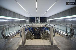
Line 1 (Granada Metro)
Rapid transit line of the Granada Metro
Distance: Approx. 7117 meters
Latitude and longitude: 37.16446944,-3.60240278
Line 1 of the Granada metro is a light rail line running from Albolote in the north to Armilla in the south, via Maracena and the center of Granada city. Today it has 26 stations and spans 15.920 km from end to end. In 2019 it received a total of 11.7 million passengers, which represents an increase of 15% compared to the previous year.
Weather in this IP's area
clear sky
22 Celsius
22 Celsius
22 Celsius
22 Celsius
1013 hPa
50 %
1013 hPa
936 hPa
10000 meters
2.06 m/s
07:58:42
20:19:41