185.116.62.103 - IP Lookup: Free IP Address Lookup, Postal Code Lookup, IP Location Lookup, IP ASN, Public IP
Country:
 Italy
ItalyRegion:
City:
Location:
Time Zone:
Postal Code:
ISP:
ASN:
language:
User-Agent:
Proxy IP:
Blacklist:
IP information under different IP Channel
ip-api
Country
Region
City
ASN
Time Zone
ISP
Blacklist
Proxy
Latitude
Longitude
Postal
Route
db-ip
Country
Region
City
ASN
Time Zone
ISP
Blacklist
Proxy
Latitude
Longitude
Postal
Route
IPinfo
Country
Region
City
ASN
Time Zone
ISP
Blacklist
Proxy
Latitude
Longitude
Postal
Route
IP2Location
185.116.62.103Country
itRegion
campania
City
zungoli
Time Zone
Europe/Rome
ISP
Language
User-Agent
Latitude
Longitude
Postal
ipdata
Country
Region
City
ASN
Time Zone
ISP
Blacklist
Proxy
Latitude
Longitude
Postal
Route
Popular places and events near this IP address
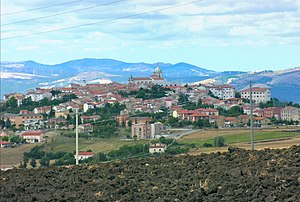
Monteleone di Puglia
Comune in Apulia, Italy
Distance: Approx. 7005 meters
Latitude and longitude: 41.16666667,15.26666667
Monteleone di Puglia (Irpinian: Munteleòne) is a hill town and comune of the province of Foggia in the Apulia region of south-eastern Italy. Its territory borders the municipalities of Accadia, Anzano di Puglia, Ariano Irpino (AV), Panni, San Sossio Baronia (AV), Sant'Agata di Puglia, Savignano Irpino (AV), Zungoli (AV).

Castel Baronia
Town in Avellino, Campania, Italy
Distance: Approx. 8555 meters
Latitude and longitude: 41.05,15.18333333
Castel Baronia is a town (comune) in the province of Avellino, Campania, Italy. Castel Baronia has a population of 1,233 inhabitants (Castellesi) and a surface of 15.3 square kilometers thus showing a population density of 80.59 inhabitants per square kilometer. It rises 639 metres above the sea level.

Flumeri
Comune in Campania, Italy
Distance: Approx. 6932 meters
Latitude and longitude: 41.07888889,15.14861111
Flumeri (Irpino: Flùmmërë) is a town and comune in the province of Avellino, Campania, southern Italy. Located in the Apennines upon a knoll within the Ufita Valley, the town is part of the Roman Catholic Diocese of Ariano Irpino-Lacedonia. Its territory borders with the municipalities of Ariano Irpino, Castel Baronia, Frigento, Grottaminarda, San Nicola Baronia, San Sossio Baronia, Sturno, Villanova del Battista and Zungoli.

San Nicola Baronia
Comune in Campania, Italy
Distance: Approx. 8555 meters
Latitude and longitude: 41.05,15.18333333
San Nicola Baronia is a town and comune in the province of Avellino, Campania, southern Italy. Located in the Apennines between the Ufita Valley and Daunian Mountains, the town is part of the Roman Catholic Diocese of Ariano Irpino-Lacedonia. Its territory borders the municipalities of Carife, Castel Baronia, Flumeri, San Sossio Baronia, and Trevico.

Scampitella
Comune in Campania, Italy
Distance: Approx. 7248 meters
Latitude and longitude: 41.1,15.28333333
Scampitella (Irpino: Scampetèdde) is a town and comune in the province of Avellino, Campania, Italy. Located upon the Apennines watershed between the Ufita Valley and Daunian Mountains, the town is part of the Roman Catholic Diocese of Ariano Irpino-Lacedonia. Its territory borders with the municipalities of Anzano di Puglia (in Apulia), Bisaccia, Lacedonia, Sant'Agata di Puglia (in Apulia), Trevico, Vallata, and Vallesaccarda.
Trevico
Comune in Campania, Italy
Distance: Approx. 8898 meters
Latitude and longitude: 41.04861111,15.23361111
Trevico is a town and comune in the province of Avellino, Campania, southern Italy. Located in the Apennines upon a steep hill at 3,576 feet (1,090 m) altitude, Trevico is the highest inhabited place in Campania. Its main produce are hams, chestnuts and potatoes, each of them is awarded PAT quality mark.

Villanova del Battista
Comune in Campania, Italy
Distance: Approx. 3251 meters
Latitude and longitude: 41.11666667,15.16666667
Villanova del Battista is a town and comune in the province of Avellino, Campania, southern Italy. Located in Irpinia historical district between the Ufita Valley and Daunian Mountains, the town is part of the Roman Catholic Diocese of Ariano Irpino-Lacedonia. Its territory borders the municipalities of Ariano Irpino, Flumeri, and Zungoli.

Anzano di Puglia
Comune in Apulia, Italy
Distance: Approx. 7079 meters
Latitude and longitude: 41.12277778,15.28805556
Anzano di Puglia is a small town and comune in the province of Foggia and region of Apulia in southeast Italy. It rises 760 metres (2,490 ft) above sea level. The town lies along the Apennines, astride the Daunian Mountains at the intersection of two ancient Roman roads, namely Via Herculea and Via Aurelia Aeclanensis, which leads to Herdonias.

1732 Irpinia earthquake
Earthquake in Southern Italy
Distance: Approx. 6762 meters
Latitude and longitude: 41.08,15.15
The 1732 Irpinia earthquake was a seismic event with a magnitude of 6.6 that affected Irpinia and part of Sannio. It occurred on 29 November 1732 at 8:40 AM local time (UTC+1). The epicenter was located in the Campanian Apennines, in the area of the Ufita Valley, which is part of the modern-day Province of Avellino.
Weather in this IP's area
light rain
6 Celsius
6 Celsius
6 Celsius
6 Celsius
1017 hPa
97 %
1017 hPa
941 hPa
6225 meters
1.06 m/s
1.66 m/s
316 degree
100 %