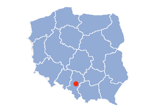
Country:
 Poland
Region:
City:
Latitude and Longitude:
Time Zone:
Postal Code:
IP information under different IP Channel
ip-api
Country
Region
City
ASN
Time Zone
ISP
Blacklist
Proxy
Latitude
Longitude
Postal
Route
IPinfo
Country
Region
City
ASN
Time Zone
ISP
Blacklist
Proxy
Latitude
Longitude
Postal
Route
MaxMind
Country
Region
City
ASN
Time Zone
ISP
Blacklist
Proxy
Latitude
Longitude
Postal
Route
Luminati
Country
PLASN
Time Zone
Europe/Warsaw
ISP
COIG S.A
Latitude
Longitude
Postal
db-ip
Country
Region
City
ASN
Time Zone
ISP
Blacklist
Proxy
Latitude
Longitude
Postal
Route
ipdata
Country
Region
City
ASN
Time Zone
ISP
Blacklist
Proxy
Latitude
Longitude
Postal
Route
Popular places and events near this IP address

Silesian Voivodeship (1920–1939)
Former voivodeship of Poland
Distance: Approx. 189 meters
Latitude and longitude: 50.25,19
The Silesian Voivodeship (Polish: województwo śląskie; German: Woiwodschaft Schlesien) was an autonomous province (voivodeship) of the Second Polish Republic. The bulk of its territory had formerly belonged to the German/Prussian Province of Silesia and became part of the newly reborn Poland as a result of the 1921 Upper Silesia plebiscite, the Geneva Conventions, three Upper Silesian Uprisings, and the eventual partition of Upper Silesia between Poland, Germany and Czechoslovakia. The remainder had been the easternmost portion of Austrian Silesia (see Cieszyn Silesia) which was partitioned between Poland and Czechoslovakia following the collapse of Austria-Hungary, the Polish–Czechoslovak War and the Spa Conference of 1920.

Wujek Coal Mine
Distance: Approx. 938 meters
Latitude and longitude: 50.244775,18.98793611
Wujek Coal Mine (Polish: Kopalnia Wujek, full name in Polish: Kopalnia Węgla Kamiennego „Wujek”; German: Oheim) is a coal mine in Katowice, Poland. It is widely known in Poland as the place of the massacre of striking miners in 1981 (most often referred to by the euphemism 'Pacification'), as well as being the site of a deadly mining accident in 2009. Mining operations began in the vicinity as early as the 16th century.

Upper Silesian Coal Basin
Distance: Approx. 189 meters
Latitude and longitude: 50.25,19
The Upper Silesian Coal Basin (USCB; Polish: Górnośląskie Zagłębie Węglowe, GZW, Czech: Hornoslezská uhelná pánev) is a coal basin in Silesia, in Poland and the Czech Republic. The Basin also contains a number of other minable resources, such as methane, cadmium, lead, silver and zinc. Coal depth is approximately 1,000 meters, and contains about 70 billion tons, with good extraction potential.

Kościuszko Park
Park in Katowice, Poland
Distance: Approx. 429 meters
Latitude and longitude: 50.2456,19.0042
The Kościuszko Park, which has existed since 1925, is one of the most famous and frequented parks in Katowice, Poland. It is situated at the street of the same name. Its foundation dates back to 1888 when a municipal park was founded on the 6 ha area of suburban grove.
Brynów
Distance: Approx. 825 meters
Latitude and longitude: 50.24150278,18.99528056
Brynów is a district in Katowice, Poland. It is located in the central part of Katowice, south-west of the immediate center, and is divided into two subdistricts: Brynów - Osiedle Zgrzebnioka is the eastern subdistrict with 7,200 inhabitants (in 2002) Brynów - Załęska Hałda is the western subdistrict with 16,800 inhabitants (in 2002) Brynów (German: Brynow) borders the following districts of Katowice: Załęże, Osiedle Paderewskiego - Muchowiec, Śródmieście, Ligota - Panewniki, Piotrowice - Ochojec. Among the landmarks of Brynów are: Kopalnia Wujek, a coal mine known as the place the government of People's Republic of Poland brutally suppressed workers demonstration in December, 1981.
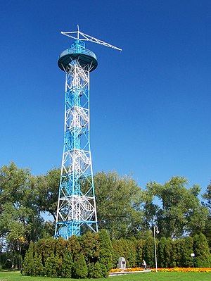
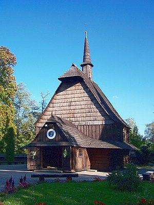
Parachute Tower in Katowice
Distance: Approx. 574 meters
Latitude and longitude: 50.24618889,19.00725
Parachute Tower in Katowice (Polish: Wieża spadochronowa w Katowicach) is a 35-metre tall lattice parachute tower built in 1937 for training parachute jumps. It was used in the first days of World War II by Germany's 73rd Infantry Division as an observation tower. The tower is the only existing parachute tower in Poland.
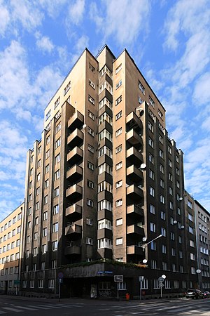
Drapacz Chmur
High-rise building in Katowice, Poland
Distance: Approx. 1174 meters
Latitude and longitude: 50.25416667,19.01361111
Drapacz Chmur (English: Skyscraper) is a historical building in Katowice, Silesia, Poland. It was the second skyscraper built in post-World War I Poland. Finished in 1934 after five years of construction, it made pioneering Polish use of steel frame construction.
Upper Silesian Industrial Region
Large industrial region in Poland
Distance: Approx. 189 meters
Latitude and longitude: 50.25,19
The Upper Silesian Industrial Region (Polish: Górnośląski Okręg Przemysłowy, pronounced [gurnɔˈɕlɔ̃skʲi ˌɔkrɛŋk pʂɛmɨˈswɔvɨ], Polish abbreviation: GOP [gɔp]; German: Oberschlesisches Industriegebiet) is a large industrial region in Poland. It lies mainly in the Silesian Voivodeship, centered on Katowice. It is situated in the northern part of Upper Silesian Coal Basin, a home of altogether 5 million people (Katowice-Ostrava metropolitan area).
Church of St. Michael the Archangel, Katowice
Distance: Approx. 882 meters
Latitude and longitude: 50.24086111,19.00416667
Church of St. Michael Archangel (Polish: Kościół św. Michała Archanioła w Katowicach) is one of the oldest buildings in Katowice.
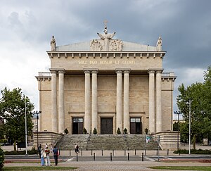
Cathedral of Christ the King, Katowice
Distance: Approx. 1376 meters
Latitude and longitude: 50.25138889,19.01861111
Archikatedra Chrystusa Króla w Katowicach (English: Archcathedral of Christ the King in Katowice) is a classicist and modernist archcathedral in Katowice-Śródmieście, Katowice, Poland. Constructed between 1927 and 1955, the Archcathedral of Christ the King is the largest archcathedral and cathedral in Poland, 120,000 metres cubed large. Construction began in the inter-war period and was funded by the autonomous Silesian Parliament (located within the Second Polish Republic).

Pacification of Wujek
Distance: Approx. 938 meters
Latitude and longitude: 50.244775,18.987936
The Pacification of Wujek was a strike-breaking action by the Polish police and army at the Wujek Coal Mine in Katowice, Poland, culminating in the massacre of nine striking miners on December 16, 1981. It was part of a large-scale action aimed to break the Solidarity free trade union after the introduction of martial law in Poland in 1981. Although the strike was suppressed, in a longer term, it turned out to be a milestone towards the collapse of the authoritarian system in Poland and, ultimately, to the collapse of the Eastern Bloc.
Roman Catholic Archdiocese of Katowice
Roman Catholic archdiocese in Poland
Distance: Approx. 1375 meters
Latitude and longitude: 50.25055556,19.01888889
The Metropolitan Archdiocese of Katowice (Latin: Archidioecesis Metropolitae Katovicensis) is the Latin Metropolitan archdiocese of the Catholic Church in Poland. It is an ecclesiastical province in Western Poland.
Weather in this IP's area
scattered clouds
16 Celsius
15 Celsius
15 Celsius
16 Celsius
1024 hPa
85 %
1024 hPa
990 hPa
10000 meters
4.42 m/s
10.94 m/s
78 degree
27 %
06:26:09
18:49:23