185.115.41.227 - IP Lookup: Free IP Address Lookup, Postal Code Lookup, IP Location Lookup, IP ASN, Public IP
Country:
Region:
City:
Location:
Time Zone:
Postal Code:
IP information under different IP Channel
ip-api
Country
Region
City
ASN
Time Zone
ISP
Blacklist
Proxy
Latitude
Longitude
Postal
Route
Luminati
Country
ASN
Time Zone
Europe/Istanbul
ISP
Netiyi Telekomunikasyon Internet. Bilg. Hiz. Tic. San. Ltd. Sti.
Latitude
Longitude
Postal
IPinfo
Country
Region
City
ASN
Time Zone
ISP
Blacklist
Proxy
Latitude
Longitude
Postal
Route
IP2Location
185.115.41.227Country
Region
amasya
City
amasya
Time Zone
Europe/Istanbul
ISP
Language
User-Agent
Latitude
Longitude
Postal
db-ip
Country
Region
City
ASN
Time Zone
ISP
Blacklist
Proxy
Latitude
Longitude
Postal
Route
ipdata
Country
Region
City
ASN
Time Zone
ISP
Blacklist
Proxy
Latitude
Longitude
Postal
Route
Popular places and events near this IP address

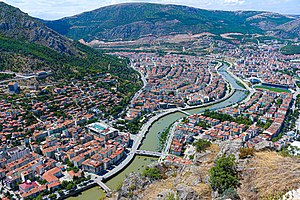
Amasya
City in the Black Sea region of Turkey
Distance: Approx. 367 meters
Latitude and longitude: 40.65,35.83305556
Amasya (Turkish pronunciation: [aˈmasja]) is a city in northern Turkey, in the Black Sea Region. It was called Amaseia or Amasia in antiquity. It is the seat of Amasya Province and Amasya District.

Kingdom of Pontus
281 BC–62 AD kingdom in northern Anatolia
Distance: Approx. 368 meters
Latitude and longitude: 40.65,35.83333333
Pontus (Ancient Greek: Πόντος Pontos) was a Hellenistic kingdom centered in the historical region of Pontus in modern-day Turkey, and ruled by the Mithridatic dynasty of Persian origin, which may have been directly related to Darius the Great of the Achaemenid dynasty. The kingdom was proclaimed by Mithridates I in 281 BC and lasted until its conquest by the Roman Republic in 63 BC. The Kingdom of Pontus reached its largest extent under Mithridates VI the Great, who conquered Colchis, Cappadocia, Bithynia, the Greek colonies of the Tauric Chersonesos, and for a brief time the Roman province of Asia. After a long struggle with Rome in the Mithridatic Wars, Pontus was defeated.
Ermiş, Amasya
Village in Amasya, Turkey
Distance: Approx. 3603 meters
Latitude and longitude: 40.63333333,35.86666667
Ermiş (formerly: Vermiş) is a village in the Amasya District, Amasya Province, Turkey. Its population is 371 (2021).
Bayezid II Mosque, Amasya
Mosque in Amasya, Turkey
Distance: Approx. 633 meters
Latitude and longitude: 40.65,35.827
The Bayezid II Mosque (Turkish: Amasya İkinci Beyazıt Külliyesi) is a historical 15th century Mosque in Amasya, Turkey. The mosque was built in 1486 by order of the Ottoman sultan Bayezid II, it is the largest Külliye of the city.

Burmali Minare Mosque
Mosque in Amasya, Turkey
Distance: Approx. 361 meters
Latitude and longitude: 40.6501,35.8324
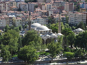
The Burmali Minare Mosque (Turkish: Burmalı Minare Camii; "Burmali Minare" means Spiral Minaret in Turkish) is a historical 13th century Mosque in Amasya, Turkey. The mosque was built between 1237 and 1247 by the Seljuks.
Büyük Aga Medrese
Madrasa in Amasya, Turkey
Distance: Approx. 611 meters
Latitude and longitude: 40.6586,35.835
Büyük Ağa Medresesi or Kapı Ağa Medresesi is a historical 15th century medrese in Amasya, Turkey.
Amasya Museum
Archaeology museum, Ethnographic museum in Amasya, Turkey
Distance: Approx. 828 meters
Latitude and longitude: 40.64944444,35.82472222
Amasya Museum, also known as Archaeological Museum of Amasya (Turkish: Amasya Müzesi or Amasya Arkeoloji Müzesi), is a national museum in Amasya, northern Turkey, exhibiting archaeological artifacts found in and around the city as well as ethnographic items related to the region's history of cultural life. Established in 1958, the museum owns nearly twenty-four thousand items for exhibition belonging to eleven historic civilizations.

Farhad and Shirin Monument
Monument in Amasya, Turkey
Distance: Approx. 2927 meters
Latitude and longitude: 40.6325,35.8119
Farhad and Shirin Monument (Turkish: Ferhat ile Şirin Heykeli) is a monument atop a rocky hill in Amasya, northern Turkey dedicated to the story about the tragic romance between Farhad and Shirin. The monument, erected by December 2012, features the bronze statues of Ferhat with a crowbar in his hand and Şirin about to jump down from the hilltop to commit suicide. The statues are 5 m (16 ft) tall.
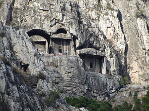
Tombs of the kings of Pontus
Tombs in Turkey
Distance: Approx. 238 meters
Latitude and longitude: 40.65333333,35.83027778
The Tombs of the kings of Pontus (Turkish: Kral Kaya Mezarları), located in Amasya, northern Turkey, are rock-carved tombs of different sizes, forming the royal necropolis of the Pontic kings. The site was added to the tentative list in the cultural category of UNESCO World Heritage Site on April 13, 2014. The royal necropolis is located on the southern hillside of the 272 m (892 ft)-high Mount Harşena north of the city Amasya and the river Yeşilırmak.

Amasya railway station
Railway station in Amasya, Turkey
Distance: Approx. 1472 meters
Latitude and longitude: 40.6541,35.8157
Amasya station on the Turkish rail network was built in 1927, near the Yeşilırmak River in the town of Amasya. It is on the Samsun-Kalın railway, which connects the Black Sea city of Samsun to the central Anatolian city of Sivas. Passenger train services are the daily Samsun-Amasya Regional and the thrice weekly Sivas-Samsun Regional.

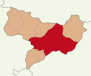
Amasya District
District of Amasya Province, Turkey
Distance: Approx. 368 meters
Latitude and longitude: 40.65,35.83333333
Amasya District (also: Merkez, meaning "central") is a district of Amasya Province of Turkey. Its seat is the city Amasya. Its area is 1,889 km2, and its population is 147,380 (2021).

Mount Harşena
Mountain peak in Turkey
Distance: Approx. 403 meters
Latitude and longitude: 40.655,35.82888889
Mount Harşena (Turkish: Harşena Dağı), is a mountain located in Amasya, the capital of the Amasya Province of Turkey. It has a height of 272 m (892 ft). Mount Harşena was added to the tentative list in the cultural category of UNESCO World Heritage Site on 13 April 2015 alongside the tombs of the kings of Pontus.
Weather in this IP's area
clear sky
10 Celsius
10 Celsius
10 Celsius
10 Celsius
1022 hPa
60 %
1022 hPa
925 hPa
10000 meters
1.18 m/s
0.99 m/s
103 degree


