185.114.108.21 - IP Lookup: Free IP Address Lookup, Postal Code Lookup, IP Location Lookup, IP ASN, Public IP
Country:
Region:
City:
Location:
Time Zone:
Postal Code:
IP information under different IP Channel
ip-api
Country
Region
City
ASN
Time Zone
ISP
Blacklist
Proxy
Latitude
Longitude
Postal
Route
Luminati
Country
ASN
Time Zone
Europe/Rome
ISP
WIIT AG
Latitude
Longitude
Postal
IPinfo
Country
Region
City
ASN
Time Zone
ISP
Blacklist
Proxy
Latitude
Longitude
Postal
Route
IP2Location
185.114.108.21Country
Region
piemonte
City
arona
Time Zone
Europe/Rome
ISP
Language
User-Agent
Latitude
Longitude
Postal
db-ip
Country
Region
City
ASN
Time Zone
ISP
Blacklist
Proxy
Latitude
Longitude
Postal
Route
ipdata
Country
Region
City
ASN
Time Zone
ISP
Blacklist
Proxy
Latitude
Longitude
Postal
Route
Popular places and events near this IP address

Arona, Piedmont
Comune in Piedmont, Italy
Distance: Approx. 1134 meters
Latitude and longitude: 45.75,8.55
Arona (Italian pronunciation: [aˈroːna]; Piedmontese: Aron-a [aˈrʊŋa]; Western Lombard: Aruna [aˈruna]) is a town and comune on Lake Maggiore, in the province of Novara (northern Italy). Its main economic activity is tourism, especially from Milan, France and Germany.

Dormelletto
Comune in Piedmont, Italy
Distance: Approx. 2941 meters
Latitude and longitude: 45.73333333,8.56666667
Dormelletto is a comune (municipality) in the Province of Novara in the Italian region of Piedmont, located about 100 kilometres (62 mi) northeast of Turin and about 30 kilometres (19 mi) north of Novara. As of 31 December 2018, it had a population of 2,600 and an area of 7.0 square kilometres (2.7 sq mi). Dormelletto borders the following municipalities: Angera, Arona, Castelletto sopra Ticino, Comignago, and Sesto Calende.

Ranco, Lombardy
Comune in Lombardy, Italy
Distance: Approx. 4635 meters
Latitude and longitude: 45.8,8.56666667
Ranco is a comune (municipality) on the shore of Lago Maggiore in the Province of Varese in the Italian region Lombardy, located about 60 kilometres (37 mi) northwest of Milan and about 20 kilometres (12 mi) west of Varese. As of 31 December 2004, it had a population of 1,188 and an area of 6.3 square kilometres (2.4 sq mi). The village has a Guide Michelin acclaimed restaurant (Il sole di Ranco) and a Transport Museum.

Taino, Lombardy
Comune in Lombardy, Italy
Distance: Approx. 4706 meters
Latitude and longitude: 45.76666667,8.61666667
Taino (Italian pronunciation: [taˈiːno]) is a comune (municipality) in the Province of Varese in the Italian region Lombardy, located about 50 km northwest of Milan and about 20 km southwest of Varese. As of 31 December 2004, it had a population of 3,353 and an area of 7.7 km2. The municipality of Taino contains the frazione (subdivision) Cheglio (pronounced [ˈkeʎʎo]).
Isolino Partegora
Distance: Approx. 1953 meters
Latitude and longitude: 45.76888889,8.57777778
Isolino Partegora (known locally as Isulin) is an islet situated at the centre of the gulf of Angera on Lago Maggiore, the only island on the lake to fall within the Italian region Lombardy. Most of the shoreline consists of marshy cane thickets, although there is a sandy beach at the southern edge of the island. The islet is about 96 by 36 m in size, with an area of roughly 3500 square metres.
Sancarlone
Statue of Charles Borromeo near Arona, Italy
Distance: Approx. 1657 meters
Latitude and longitude: 45.77027778,8.54333333
The San Carlone or Sancarlone or the Colossus of San Carlo Borromeo is a massive copper statue by Giovanni Battista Crespi, erected between 1614 and 1698, near Arona, Italy. It represents Charles Borromeo, a Catholic saint and former archbishop of Milan. According to sculptor Frédéric Auguste Bartholdi "The statue of St.
Arona railway station
Railway station in Italy
Distance: Approx. 442 meters
Latitude and longitude: 45.75527778,8.55944444
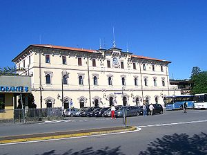
Arona railway station (Italian: Stazione di Arona) serves the town and comune of Arona, in the Piedmont region of northwestern Italy. The station forms part of the Lombard railway service, with local and direct connections with Milan.

Rocca Borromeo di Angera
Building in Angera, Italy
Distance: Approx. 2030 meters
Latitude and longitude: 45.77416667,8.57138889
The Rocca Borromeo di Angera, or Rocca d'Angera, also called Borromeo Castle, is a rocca on a hilltop above the town of Angera in the Province of Varese on the southern shores of Lago Maggiore. It has medieval origins and initially belonged to the Milanese archbishop. It passed then to the Visconti of Milan and later to the Borromeos, who are still the owners.

Villa Farragiana a Meina
Building in Meina, Italy
Distance: Approx. 2864 meters
Latitude and longitude: 45.78207,8.54108
The Villa Farragiana a Meina is a 19th-century Neoclassical-style rural palace located on the shores of Lago Maggiore, between the towns of Meina and Arona in the Province of Novara, region of Piedmont, Italy. This villa differs from the Villa Faraggiana at Albissola Marina in the Province of Savona.
Sacro Monte di Arona
Distance: Approx. 1662 meters
Latitude and longitude: 45.77027,8.54323
The Sacro Monte di Arona, devoted to Charles Borromeo, is part of the Sacri Monti built in the 16th and 17th centuries. It is located in the territory of the town of Arona, province of Novara, region of Piedmont, Italy.

Lagoni di Mercurago Natural Park
Distance: Approx. 2690 meters
Latitude and longitude: 45.735,8.552
The Lagoni di Mercurago Nature Park, established in 1980, is a natural reserve in Piedmont, located in Mercurago, a hamlet near Arona, consisting of many lakes with swamp vegetation.

Dal Pozzo Castle
Castle in Italy
Distance: Approx. 2163 meters
Latitude and longitude: 45.75055556,8.53194444
The Dal Pozzo Castle is a castle of medieval origin located in Oleggio Castello, Province of Novara, Piedmont, northern Italy. In the 19th century, it underwent profound transformations providing it the current neo-Gothic Tudor aspect. Today it is the seat of a hotel.
Weather in this IP's area
clear sky
10 Celsius
8 Celsius
10 Celsius
10 Celsius
1014 hPa
22 %
1014 hPa
970 hPa
10000 meters
1.03 m/s


