Country:
Region:
City:
Latitude and Longitude:
Time Zone:
Postal Code:
IP information under different IP Channel
ip-api
Country
Region
City
ASN
Time Zone
ISP
Blacklist
Proxy
Latitude
Longitude
Postal
Route
Luminati
Country
Region
eng
City
peterborough
ASN
Time Zone
Europe/London
ISP
Talk Straight Ltd.
Latitude
Longitude
Postal
IPinfo
Country
Region
City
ASN
Time Zone
ISP
Blacklist
Proxy
Latitude
Longitude
Postal
Route
db-ip
Country
Region
City
ASN
Time Zone
ISP
Blacklist
Proxy
Latitude
Longitude
Postal
Route
ipdata
Country
Region
City
ASN
Time Zone
ISP
Blacklist
Proxy
Latitude
Longitude
Postal
Route
Popular places and events near this IP address

Thorpe Hall (Peterborough)
Historic site in Longthorpe
Distance: Approx. 1715 meters
Latitude and longitude: 52.57263889,-0.27430556
Thorpe Hall at Longthorpe in the city of Peterborough, Cambridgeshire, is a Grade I listed building, built by Peter Mills between 1653 and 1656, for the Lord Chief Justice, Oliver St John. The house is unusual in being one of the very few mansions built during the Commonwealth period. After a period as a hospital, it is currently used as a Sue Ryder hospice.
Longthorpe
Human settlement in England
Distance: Approx. 1466 meters
Latitude and longitude: 52.567,-0.283
Longthorpe is an area of the city of Peterborough, in the ceremonial county of Cambridgeshire, England. Located two miles (3.2 km) west from the city centre, the area covers 1,390 acres (560 hectares). For electoral purposes it forms part of Peterborough West ward.
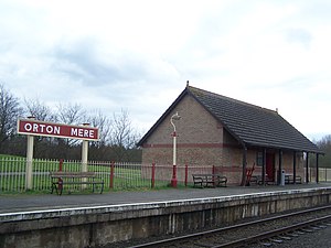
Orton Mere railway station
Distance: Approx. 938 meters
Latitude and longitude: 52.559741,-0.280981
Orton Mere is a station on the Nene Valley Railway and is situated between Ferry Meadows and Peterborough Nene Valley, adjacent to the River Nene. Orton Mere provides access to the eastern end of the Nene Park. At Orton Mere, the Nene Valley Railway passes under the Orton Parkway, part of the complex road system built when Peterborough was allocated New Town status.

Peterborough Nene Valley railway station
Distance: Approx. 1732 meters
Latitude and longitude: 52.567705,-0.247766
Peterborough Nene Valley is a station on the Nene Valley Railway and is the current eastern terminus of the line. Situated adjacent to Railworld, the station can be found west of the East Coast Main Line, close to the Junction of London Road and Oundle Road. The station was built in 1986 as part of the Nene Valley Railway's Peterborough extension.

Woodston, Peterborough
Area of Peterborough, England
Distance: Approx. 908 meters
Latitude and longitude: 52.562,-0.256
Woodston is a largely residential and industrial area of the city of Peterborough, in the ceremonial county of Cambridgeshire, England. For electoral purposes, it forms part of Fletton ward in North West Cambridgeshire constituency. Oundle Road runs through most of Woodston into the Ortons.
St Olga Ukrainian Catholic Church
Church in Cambridgeshire, England
Distance: Approx. 1056 meters
Latitude and longitude: 52.5624,-0.25386
St Olga Ukrainian Catholic Church, Woodston, Peterborough, England was built in 1964, and named for Olga of Kyiv. There is a Ukrainian Mission based in this church. The parish priest is Fr Roman Badiak.

Woodston Ponds
Distance: Approx. 1160 meters
Latitude and longitude: 52.568,-0.264
Woodston Ponds is an 8.9 hectare Local Nature Reserve between the River Nene and the Nene Valley Railway in Peterborough in Cambridgeshire. It is managed by the Wildlife Trust for Bedfordshire, Cambridgeshire and Northamptonshire. The site was formerly settling ponds to remove washings from sugar beet.

Fletton railway station
Distance: Approx. 1630 meters
Latitude and longitude: 52.5541,-0.2442
Fletton railway station was a railway station in Fletton, Cambridgeshire just south of Peterborough. It was once home to an extensive goods yard.
Orton Community Sixth Form
Distance: Approx. 1311 meters
Latitude and longitude: 52.5525,-0.2848
Orton Community Sixth Form is a consortium sixth form for Bushfield Community College and Orton Longueville School.

Railworld Wildlife Haven
Railway museum in Peterborough, England
Distance: Approx. 1732 meters
Latitude and longitude: 52.56791667,-0.24805556
Railworld Wildlife Haven is a charity in Peterborough which has a nature haven, a model railway and other exhibits. It is located on a landscaped former coal storage yard which once served Peterborough Power Station. It was founded by Rev.

The Boardwalks
Nature preserve in Peterborough, Cambridgeshire
Distance: Approx. 1346 meters
Latitude and longitude: 52.569,-0.26
The Boardwalks is a 7.8 hectare Local Nature Reserve in Peterborough in Cambridgeshire. It is owned and managed by Peterborough City Council. The site runs along the north bank of the River Nene.
Peterborough City Rowing Club
British rowing club
Distance: Approx. 1382 meters
Latitude and longitude: 52.570066,-0.270664
Peterborough City Rowing Club is a rowing club based at Thorpe Meadows, Peterborough, Cambridgeshire.
Weather in this IP's area
broken clouds
6 Celsius
5 Celsius
5 Celsius
8 Celsius
1012 hPa
93 %
1012 hPa
1010 hPa
10000 meters
2.06 m/s
330 degree
75 %
07:27:15
16:05:13
