Country:
 Switzerland
Region:
City:
Latitude and Longitude:
Time Zone:
Postal Code:
IP information under different IP Channel
ip-api
Country
Region
City
ASN
Time Zone
ISP
Blacklist
Proxy
Latitude
Longitude
Postal
Route
IPinfo
Country
Region
City
ASN
Time Zone
ISP
Blacklist
Proxy
Latitude
Longitude
Postal
Route
MaxMind
Country
Region
City
ASN
Time Zone
ISP
Blacklist
Proxy
Latitude
Longitude
Postal
Route
Luminati
Country
CHRegion
zh
City
zurich
ASN
Time Zone
Europe/Zurich
ISP
Genossenschaft GGA Maur
Latitude
Longitude
Postal
db-ip
Country
Region
City
ASN
Time Zone
ISP
Blacklist
Proxy
Latitude
Longitude
Postal
Route
ipdata
Country
Region
City
ASN
Time Zone
ISP
Blacklist
Proxy
Latitude
Longitude
Postal
Route
Popular places and events near this IP address
Schweizer Radio DRS
Former Swiss German-language radio broadcaster
Distance: Approx. 715 meters
Latitude and longitude: 47.40111111,8.53555556
Schweizer Radio: Radio der deutschen und rätoromanischen Schweiz (SR DRS; "Swiss Radio: Radio of the German and Romansh Switzerland") was a company of SRG SSR which operated the public German-language radio stations of Switzerland from 1931 until 2012. On 1 January 2011, Schweizer Fernsehen (SF) and Schweizer Radio DRS began the process of merging the two entities into Schweizer Radio und Fernsehen (SRF). On 16 December 2012, the merger was complete, with SF and SR DRS adopting the Schweizer Radio und Fernsehen (SRF) name.

Wipkingen
Distance: Approx. 1014 meters
Latitude and longitude: 47.39266944,8.52342778
Wipkingen is a quarter in the district 10 in Zürich. It was formerly a municipality of its own, having been incorporated into Zürich in 1893. The quarter has a population of 15,446 distributed on an area of 2.11 km².

Escher Wyss
Area in Zurich, Switzerland
Distance: Approx. 1229 meters
Latitude and longitude: 47.39083333,8.5225
Escher Wyss is a quarter in the district 5 of Zürich, centered on the Escher-Wyss-Platz square. Escher Wyss was formerly a part of Aussersihl municipality, which was incorporated into Zürich in 1893. The quarter has a population of 2,727 distributed on an area of 1.27 km2 (1⁄2 sq.

Käferberg
Summits of a wooded mountain
Distance: Approx. 608 meters
Latitude and longitude: 47.40533,8.52021
Käferberg (el. 571 metres or 1,873 feet) and Waidberg (el. 601 metres or 1,972 feet) are the summits of a wooded range of hills overlooking the inner city of Zürich, Zürichsee, Albis chain and Uetliberg, as well as the Limmat Valley and the Zürcher Unterland in Switzerland.

Kunsthalle Zürich
Distance: Approx. 1373 meters
Latitude and longitude: 47.38927778,8.52520278
The Kunsthalle Zürich is a kunsthalle (a contemporary art exhibition centre) in Zürich, Switzerland. Founded in 1985, it is located on Limmatstrasse, near the city centre. A number of temporary exhibitions are organized each year.
Louis-Häfliger-Park
Distance: Approx. 1348 meters
Latitude and longitude: 47.4125,8.53388889
The Louis-Häfliger-Park in Oerlikon, Zurich, covers 5,000 m2 (53,820 sq ft) and is embedded between the Regina-Kägi-Hof co-operative settlement, the existing production buildings for Oerlikon-Contraves AG, and new service buildings. It is a neighbourhood park allowing people who live or work here to relax and meet. The park is named after Louis Häfliger (1904–1993), "Saviour of Mauthausen".

Gustav-Ammann-Park
Public park in Oerlikon, Zurich
Distance: Approx. 1258 meters
Latitude and longitude: 47.41138889,8.53444444
The Gustav-Ammann-Park is a public park in Oerlikon, Zurich on the former premises of Oerlikon-Bührle and covers 32,291 ft2. In 1996, the privately owned park became a preserve. One year later, the formerly nameless facility was handed over to the population as Gustav-Ammann-Park.

Zürich Wipkingen railway station
Railway station in the Wipkingen quarter of the Swiss city of Zurich
Distance: Approx. 1092 meters
Latitude and longitude: 47.392,8.5291
Zürich Wipkingen railway station (‹See Tfd›German: Bahnhof Zürich Wipkingen) is a railway station in the Wipkingen quarter of the Swiss city of Zürich. It is situated on the Zürich–Winterthur railway line, which was built by the Swiss Northeastern Railway (Schweizerische Nordostbahn). The route towards Zürich HB leads over the Wipkingen viaduct (Wipkinger Viadukt).

Irchelpark
Park in Zürich, Switzerland
Distance: Approx. 1389 meters
Latitude and longitude: 47.39836944,8.54390833
Irchelpark is the biggest public park in the city of Zürich in Switzerland, and claims to be the most spacious park in Switzerland.
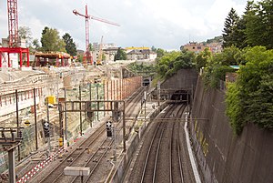
Käferberg Tunnel
Railway tunnel in Zürich, Switzerland
Distance: Approx. 614 meters
Latitude and longitude: 47.4032,8.5339
The Käferberg Tunnel (‹See Tfd›German: Käferbergtunnel) is a railway tunnel in the Swiss city of Zürich. The tunnel runs under the Käferberg hill from the western approaches to Zürich Hauptbahnhof to a portal to the south of Oerlikon station. It is 2,119 metres (6,952 ft) long and carries twin standard gauge (1,435 mm or 4 ft 8+1⁄2 in) tracks electrified at 15 kV AC 16 2/3 Hz using overhead catenary.

Kantonsschule Zürich Nord
Distance: Approx. 1008 meters
Latitude and longitude: 47.4083,8.5351
Kantonsschule Zürich Nord (KZN) is a Swiss cantonal gymnasium (Langzeit-, Kurzzeit, und Fachmittelschule) in Oerlikon, northern Zürich, Switzerland. The school, which first opened in 2012, was formed by the merger of Kantonsschule Zürich Birch and Kantonsschule Oerlikon (see German WP).

Swissmill Tower
Tall grain silo in Zürich, Switzerland
Distance: Approx. 1335 meters
Latitude and longitude: 47.389628,8.527086
The Swissmill Tower, also known as Kornhaus, is the tallest operating grain elevator in the world. Standing at 118 metres (387 ft), it is the second-tallest building in the Swiss city of Zürich.
Weather in this IP's area
broken clouds
10 Celsius
10 Celsius
9 Celsius
11 Celsius
1010 hPa
89 %
1010 hPa
949 hPa
10000 meters
1.54 m/s
75 %
07:33:16
18:53:44