Country:
Region:
City:
Latitude and Longitude:
Time Zone:
Postal Code:
IP information under different IP Channel
ip-api
Country
Region
City
ASN
Time Zone
ISP
Blacklist
Proxy
Latitude
Longitude
Postal
Route
Luminati
Country
Region
z
City
hasolelim
ASN
Time Zone
Asia/Jerusalem
ISP
ITC NG ltd
Latitude
Longitude
Postal
IPinfo
Country
Region
City
ASN
Time Zone
ISP
Blacklist
Proxy
Latitude
Longitude
Postal
Route
db-ip
Country
Region
City
ASN
Time Zone
ISP
Blacklist
Proxy
Latitude
Longitude
Postal
Route
ipdata
Country
Region
City
ASN
Time Zone
ISP
Blacklist
Proxy
Latitude
Longitude
Postal
Route
Popular places and events near this IP address

Bethlehem of Galilee
Cooperative community in northern Israel
Distance: Approx. 4161 meters
Latitude and longitude: 32.73666667,35.19138889
Bethlehem of Galilee (Hebrew: בֵּית לֶחֶם הַגְּלִילִית, Beit Lehem HaGlilit; lit. "the Galilean Bethlehem") or Bethlehem-in-the-Galilee is a moshav in northern Israel. Located in the Galilee near Kiryat Tivon, around 10 kilometres north-west of Nazareth and 30 kilometres east of Haifa, it falls under the jurisdiction of the Jezreel Valley Regional Council.

National Water Carrier of Israel
Israeli cross country water supply network
Distance: Approx. 3587 meters
Latitude and longitude: 32.774575,35.253925
The National Water Carrier of Israel (Hebrew: המוביל הארצי, HaMovil HaArtzi) is the largest water project in Israel, completed in 1964. Its main purpose is to transfer water from the Sea of Galilee in the north of the country to the highly populated center and the arid south and to enable efficient use of water and regulation of the water supply in the country. It is about 130 kilometers (81 mi) long.

Sepphoris
Former village and archaeological site located in the Galilee region of Israel
Distance: Approx. 4171 meters
Latitude and longitude: 32.74555556,35.27861111
Sepphoris ( sif-OR-iss; Ancient Greek: Σέπφωρις, romanized: Sépphōris), known in Hebrew as Tzipori (צִפּוֹרִי Ṣīppōrī) and in Arabic as Saffuriya (صفورية Ṣaffūriya) is an archaeological site and former Palestinian village located in the central Galilee region of Israel, 6 kilometres (3.7 mi) north-northwest of Nazareth. It lies 286 meters (938 ft) above sea level and overlooks the Beit Netofa Valley. The site holds a rich and diverse historical and architectural legacy that includes remains from the Hellenistic, Roman, Byzantine, early Islamic, Crusader, Mamluk and Ottoman periods.

Zarzir
Town in Israel
Distance: Approx. 2370 meters
Latitude and longitude: 32.72722222,35.22472222
Zarzir (Arabic: زرزير, Hebrew: זַרְזִיר), also known as Beit Zarzir, is an Arab local council located 10 kilometres (6.2 mi) west of the city of Nazareth in the Northern District of Israel. In 2022 it had a population of 8,565, consisting of five Bedouin tribes, Mazarib, Grifat, Haib, Jawamis, and Eyadat.

Bir al-Maksur
Local council in Israel
Distance: Approx. 3586 meters
Latitude and longitude: 32.77722222,35.22083333
Bir al-Maksur or Beer el-Maksura (Arabic: بئر المكسور; Hebrew: בִּיר אל-מַכְּסוּר) is an Arab Bedouin local council in the Northern District of Israel located 15 kilometres (9.3 mi) north-west of Nazareth. In 2022 its population was 10,175. The villagers belong to the Arab el-Hujeirat Bedouin tribe, settled there in the 1950s.
HaSolelim
Place in Northern, Israel
Distance: Approx. 502 meters
Latitude and longitude: 32.75027778,35.23777778
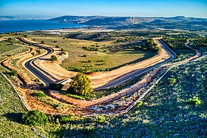
HaSolelim (Hebrew: הַסּוֹלְלִים, lit. 'The Road Builders') is a kibbutz in northern Israel. Located near Kiryat Tiv'on, Nazareth and Shefa-'Amr, it falls under the jurisdiction of Jezreel Valley Regional Council. In 2022 it had a population of 983.

Alon HaGalil
Community settlement in northern Israel
Distance: Approx. 1704 meters
Latitude and longitude: 32.75722222,35.22055556
Alon HaGalil (Hebrew: אַלּוֹן הַגָּלִיל, lit. 'Oak of the Galilee') is a community settlement in northern Israel. Located in the Lower Galilee, it falls under the jurisdiction of Jezreel Valley Regional Council. In 2022 it had a population of 1,135.

Givat Ela
Community settlement in northern Israel
Distance: Approx. 2957 meters
Latitude and longitude: 32.72166667,35.24361111
Givat Ela (Hebrew: גִּבְעַת אֵלָה, lit. 'Ela Hill') is a community settlement in northern Israel. Located near Ilut and Zarzir, it falls under the jurisdiction of Jezreel Valley Regional Council. In 2022 it had a population of 1,896.

Shimshit
Place in Northern, Israel
Distance: Approx. 1923 meters
Latitude and longitude: 32.73333333,35.24666667
Shimshit (Hebrew: שִׁמְשִׁית) is a secular community settlement in northern Israel. Located to the north-west of Nazareth, it falls under the jurisdiction of Jezreel Valley Regional Council. In 2022 it had a population of 2,441.
Ilut Stadium
Distance: Approx. 4151 meters
Latitude and longitude: 32.72090278,35.26576944
The Ilut Stadium is a football stadium in Ilut, located near Nazareth in northern Israel. The stadium is the home ground of Maccabi Ahi Nazareth. Bnei Sakhnin, Hapoel Acre and Hapoel Nazareth Illit have all played at the ground whilst their stadiums were being upgraded.

Yiftahel
Distance: Approx. 1107 meters
Latitude and longitude: 32.755375,35.227725
Yiftahel (Hebrew: יפתחאל) is an archaeological site located in the Lower Galilee in northern Israel. Various salvage excavations took place here between 1992 and 2008. The best known periods of occupation are the Early Bronze Age I and Pre-Pottery Neolithic B. In the Early Bronze Age village ca.

Tzippori
Place in Northern, Israel
Distance: Approx. 4171 meters
Latitude and longitude: 32.74555556,35.27861111
Tzippori (Hebrew: ציפורי) is a moshav in northern Israel, in the Lower Galilee. The moshav is within the jurisdiction of the Jezreel Valley Regional Council. The moshav was founded 3 km southeast of the ancient settlement of Sepphoris, after which it was named.
Weather in this IP's area
scattered clouds
25 Celsius
25 Celsius
25 Celsius
26 Celsius
1017 hPa
50 %
1017 hPa
996 hPa
10000 meters
5.67 m/s
5.93 m/s
95 degree
33 %
06:03:04
16:42:39