Country:
 France
Region:
City:
Latitude and Longitude:
Time Zone:
Postal Code:
IP information under different IP Channel
ip-api
Country
Region
City
ASN
Time Zone
ISP
Blacklist
Proxy
Latitude
Longitude
Postal
Route
IPinfo
Country
Region
City
ASN
Time Zone
ISP
Blacklist
Proxy
Latitude
Longitude
Postal
Route
MaxMind
Country
Region
City
ASN
Time Zone
ISP
Blacklist
Proxy
Latitude
Longitude
Postal
Route
Luminati
Country
FRASN
Time Zone
Europe/Paris
ISP
ADISTA SAS
Latitude
Longitude
Postal
db-ip
Country
Region
City
ASN
Time Zone
ISP
Blacklist
Proxy
Latitude
Longitude
Postal
Route
ipdata
Country
Region
City
ASN
Time Zone
ISP
Blacklist
Proxy
Latitude
Longitude
Postal
Route
Popular places and events near this IP address
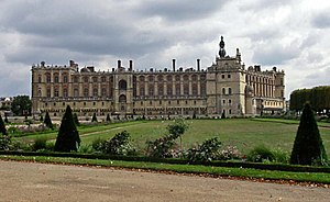
Saint-Germain-en-Laye
French commune
Distance: Approx. 2109 meters
Latitude and longitude: 48.8989,2.0938
Saint-Germain-en-Laye (French: [sɛ̃ ʒɛʁmɛ̃ ɑ̃ lɛ] ) is a commune in the Yvelines department in the Île-de-France in north-central France. It is located in the western suburbs of Paris, 19.1 km (11.9 mi) from the centre of Paris. Inhabitants are called Saint-Germanois or Saint-Germinois.

Mareil-Marly
Commune in Île-de-France, France
Distance: Approx. 2112 meters
Latitude and longitude: 48.8825,2.0775
Mareil-Marly (French pronunciation: [maʁɛj maʁli]) is a commune in the Yvelines department in the Île-de-France region in north-central France.

Fourqueux
Part of Saint-Germain-en-Laye in Île-de-France, France
Distance: Approx. 1349 meters
Latitude and longitude: 48.8875,2.0661
Fourqueux (French pronunciation: [fuʁkø] ) is a former commune in the Yvelines department in the Île-de-France in north-central France. On 1 January 2019, it was merged into the commune Saint-Germain-en-Laye. It is a small suburb 20 km west of Paris.

Arrondissement of Saint-Germain-en-Laye
Arrondissement in Île-de-France, France
Distance: Approx. 1367 meters
Latitude and longitude: 48.90194444,2.08333333
The arrondissement of Saint-Germain-en-Laye is an arrondissement of France in the Yvelines department in the Île-de-France region. It has 44 communes. Its population is 524,951 (2019), and its area is 350.9 km2 (135.5 sq mi).

Saint-Germain-en-Laye station
Distance: Approx. 2203 meters
Latitude and longitude: 48.898,2.095
Saint-Germain-en-Laye is the main railway station serving Saint-Germain-en-Laye, France. The station opened on 14 August 1847 with the opening of the ligne de Saint Germain (from Paris to Saint-Germain), an atmospheric railway. Twelve years later, conventional locomotives replaced the atmospheric powered engines.

Saint-Germain-en-Laye–Grande-Ceinture station
Distance: Approx. 704 meters
Latitude and longitude: 48.90305556,2.07305556
Saint-Germain-en-Laye–Grande-Ceinture is railway station in Saint-Germain-en-Laye, France. Its creation was decided on 11 March 1875 and opened in 1877. The station was built as a passenger stop on the Grande Ceinture but the line soon lost its passenger traffic only to become a goods station.
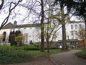
Musée départemental Maurice Denis "The Priory"
Distance: Approx. 1797 meters
Latitude and longitude: 48.8927,2.0872
The Musée départemental Maurice Denis "The Priory" is a museum dedicated to Nabi art located in Saint-Germain-en-Laye, in the Parisian region (Île-de-France). The museum is dedicated to Maurice Denis, a French symbolist Nabi painter. The museum showcases his work as well as that of many other members of the school.

Chambourcy
Commune in Île-de-France, France
Distance: Approx. 1919 meters
Latitude and longitude: 48.9067,2.0411
Chambourcy (French pronunciation: [ʃɑ̃buʁsi] ) is a commune in the Yvelines department in the Île-de-France region in north-central France. It is located 3 km (1.9 mi) west of Saint-Germain-en-Laye and about 25 km (16 mi) west of Paris. Its inhabitants are called Camboriciens.

Stade Georges Lefèvre
Sports complex in Paris
Distance: Approx. 1885 meters
Latitude and longitude: 48.9126,2.0815
The Stade Georges Lefèvre, officially known as the Stade Municipal Georges Lefèvre, and formerly as the Stade des Loges, is a sports complex in Saint-Germain-en-Laye, near Paris, France. It is located just across the street from the Camp des Loges, the former training ground of French football club Paris Saint-Germain. Between 1904 and 1970, the Stade Georges Lefèvre was the home stadium and training ground of former French football club Stade Saint-Germain.
Canton of Saint-Germain-en-Laye
Distance: Approx. 1830 meters
Latitude and longitude: 48.9,2.09
The canton of Saint-Germain-en-Laye is an administrative division of the Yvelines department, northern France. It was created at the French canton reorganisation which came into effect in March 2015. Its seat is in Saint-Germain-en-Laye.

Musée Claude-Debussy
Biographical museum in Saint-Germain-en-Laye, France
Distance: Approx. 2054 meters
Latitude and longitude: 48.89694444,2.09277778
The Musée Claude-Debussy, or Maison Claude Debussy, is the birthplace of the composer Claude Debussy, in Saint-Germain-en-Laye, a western suburb of Paris, France. It contains a small museum about the composer. The house was built in the 17th century.

Centre hospitalier intercommunal de Poissy-Saint-Germain-en-Laye
Hospital in Île-de-France, France
Distance: Approx. 1436 meters
Latitude and longitude: 48.8981179,2.0844941
The Centre hospitalier intercommunal de Poissy-Saint-Germain-en-Laye is a celebrated teaching hospital in Poissy and Saint Germain en Laye. Part of the Assistance Publique – Hôpitaux de Paris and a teaching hospital of Versailles Saint-Quentin-en-Yvelines University. It has been created in 1997.
Weather in this IP's area
broken clouds
19 Celsius
18 Celsius
18 Celsius
20 Celsius
1009 hPa
72 %
1009 hPa
999 hPa
10000 meters
4.63 m/s
220 degree
75 %
07:18:54
20:20:07