185.105.211.65 - IP Lookup: Free IP Address Lookup, Postal Code Lookup, IP Location Lookup, IP ASN, Public IP
Country:
Region:
City:
Location:
Time Zone:
Postal Code:
IP information under different IP Channel
ip-api
Country
Region
City
ASN
Time Zone
ISP
Blacklist
Proxy
Latitude
Longitude
Postal
Route
Luminati
Country
ASN
Time Zone
Europe/Rome
ISP
P.C. Service Srl
Latitude
Longitude
Postal
IPinfo
Country
Region
City
ASN
Time Zone
ISP
Blacklist
Proxy
Latitude
Longitude
Postal
Route
IP2Location
185.105.211.65Country
Region
umbria
City
perugia
Time Zone
Europe/Rome
ISP
Language
User-Agent
Latitude
Longitude
Postal
db-ip
Country
Region
City
ASN
Time Zone
ISP
Blacklist
Proxy
Latitude
Longitude
Postal
Route
ipdata
Country
Region
City
ASN
Time Zone
ISP
Blacklist
Proxy
Latitude
Longitude
Postal
Route
Popular places and events near this IP address

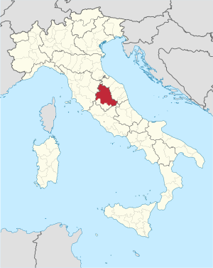
Umbria
Region of Italy
Distance: Approx. 41 meters
Latitude and longitude: 43.1121,12.3888
Umbria ( UM-bree-ə; Italian: [ˈumbrja]) is a region of central Italy. It includes Lake Trasimeno and Marmore Falls, and is crossed by the Tiber. It is the only landlocked region on the Apennine Peninsula.

Perugia
Comune in Umbria, Italy
Distance: Approx. 36 meters
Latitude and longitude: 43.11222222,12.38888889
Perugia ( pə-ROO-jə, US also -jee-ə, pay-; Italian: [peˈruːdʒa] ; Latin: Perusia) is the capital city of Umbria in central Italy, crossed by the River Tiber. The city is located about 164 km (102 mi) north of Rome and 148 km (92 mi) southeast of Florence. It covers a high hilltop and part of the valleys around the area.

Second Triumvirate
Roman political organisation (43–32 BC)
Distance: Approx. 36 meters
Latitude and longitude: 43.11222222,12.38888889
The Second Triumvirate was an extraordinary commission and magistracy created at the end of the Roman republic for Mark Antony, Lepidus, and Octavian to give them practically absolute power. It was formally constituted by law on 27 November 43 BC with a term of five years; it was renewed in 37 BC for another five years before expiring in 32 BC. Constituted by the lex Titia, the triumvirs were given broad powers to make or repeal legislation, issue judicial punishments without due process or right of appeal, and appoint all other magistrates. The triumvirs also split the Roman world into three sets of provinces.

Province of Perugia
Province of Italy
Distance: Approx. 41 meters
Latitude and longitude: 43.1121,12.3888
The province of Perugia (Italian: provincia di Perugia) is the larger of the two provinces in the Umbria region of Italy, comprising two-thirds of both the area and population of the region. Its capital is the city of Perugia. The province covered all of Umbria until 1927, when the province of Terni was carved out of its southern third.

Tiberina Republic
Distance: Approx. 36 meters
Latitude and longitude: 43.11222222,12.38888889
The so-called Tiberina Republic (Italian: Repubblica Tiberina) was a revolutionary municipality proclaimed on 4 February 1798, when republicans took power in the city of Perugia. It was an occupation zone that took its name from the river Tiber. A month later, the government of all the Papal States was changed into a republic: the Roman Republic, which Perugia belonged to.

Perugia Cathedral
Catholic cathedral in Perugia, Umbria, Italy
Distance: Approx. 66 meters
Latitude and longitude: 43.112685,12.389209
Perugia Cathedral (Italian: Duomo di Perugia), officially the Metropolitan Cathedral of St. Lawrence (Cattedrale Metropolitana di San Lorenzo), is a Roman Catholic cathedral in Perugia, Umbria, central Italy, dedicated to Saint Lawrence. Formerly the seat of the bishops and archbishops of Perugia, it has been since 1986 the archiepiscopal seat of the Archdiocese of Perugia-Città della Pieve.
Palazzo dei Priori
Building in Perugia, Italy
Distance: Approx. 27 meters
Latitude and longitude: 43.112,12.389
The Palazzo dei Priori or comunale is one of the best examples in Italy of a public palace from the communal era (11th century). It is located in the central Piazza IV Novembre in Perugia, Umbria. It extends along Corso Vannucci up to Via Boncambi.

Roman Catholic Archdiocese of Perugia–Città della Pieve
Roman Catholic archdiocese in Italy
Distance: Approx. 47 meters
Latitude and longitude: 43.1125,12.3891
The Archdiocese of Perugia-Città della Pieve (Latin: Archidioecesis Perusina-Civitatis Plebis) is a Latin archdiocese of the Catholic Church. It was historically the Diocese of Perugia. It became the Archdiocese of Perugia in 1882, but without suffragans.
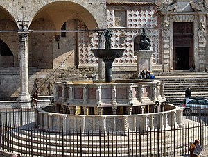
Fontana Maggiore
Fountain in Italy
Distance: Approx. 41 meters
Latitude and longitude: 43.112192,12.38881
The Fontana Maggiore, a masterpiece of medieval sculpture, placed in the centre of Piazza IV Novembre (formerly Piazza Grande), is the monument symbol of the city of Perugia.
Castello di Monterone (Monterone Castle)
Restored 13th-century castle in Perugia, Italy
Distance: Approx. 41 meters
Latitude and longitude: 43.1121,12.3888
Castello di Monterone, known also as Castello Piceller, is a small restored 13th-century castle in Perugia, Italy. It is located in the road that connects Perugia to Assisi, through Ponte San Giovanni. Very close to the Monastery of San Pietro and to the Church of San Bevignate, this street is one of the "royal roads", that led out of the town through the main gates of Perugia, along a road network already used by the Etruscans and Romans.

Etruscan Well
Ancient well in the old town of Perugia
Distance: Approx. 120 meters
Latitude and longitude: 43.11278,12.39045
The Etruscan Well, also known as "Sorbello well" from the name of the noble family which still owns the mansion which includes the structure, is located in the old town of Perugia. Entrance to the well, currently open to the public as a museum, is from no. 18 piazza Danti, through a covered walkway which leads to the underground sections of Palazzo Sorbello.
Piazza IV Novembre
Square in Perugia, Italy
Distance: Approx. 41 meters
Latitude and longitude: 43.1121,12.3888
Piazza IV Novembre is a square in the historic center of Perugia. The asymmetrical square opens up to the convergence of the five road axes that structure the medieval city and for its scenography it has represented in every era the privileged place of urban functions: here the ancient forum was located and there are preserved monuments connected to the system urban planning of the Etruscan-Roman city.
Weather in this IP's area
broken clouds
6 Celsius
2 Celsius
4 Celsius
6 Celsius
1027 hPa
70 %
1027 hPa
971 hPa
10000 meters
5.36 m/s
9.83 m/s
315 degree
75 %

