Country:
 Austria
Region:
City:
Latitude and Longitude:
Time Zone:
Postal Code:
IP information under different IP Channel
ip-api
Country
Region
City
ASN
Time Zone
ISP
Blacklist
Proxy
Latitude
Longitude
Postal
Route
IPinfo
Country
Region
City
ASN
Time Zone
ISP
Blacklist
Proxy
Latitude
Longitude
Postal
Route
MaxMind
Country
Region
City
ASN
Time Zone
ISP
Blacklist
Proxy
Latitude
Longitude
Postal
Route
Luminati
Country
ATASN
Time Zone
Europe/Vienna
ISP
MMC GmbH
Latitude
Longitude
Postal
db-ip
Country
Region
City
ASN
Time Zone
ISP
Blacklist
Proxy
Latitude
Longitude
Postal
Route
ipdata
Country
Region
City
ASN
Time Zone
ISP
Blacklist
Proxy
Latitude
Longitude
Postal
Route
Popular places and events near this IP address

International Institute for Applied Systems Analysis
International research organization in Austria
Distance: Approx. 4256 meters
Latitude and longitude: 48.068272,16.358171
The International Institute for Applied Systems Analysis (IIASA) is an independent International research institute located in Laxenburg, near Vienna in Austria, founded as an East-West scientific cooperation initiative during the Cold War. Through its research programs and initiatives, the institute conducts policy-oriented interdisciplinary research into issues too large or complex to be solved by a single country or academic discipline. These include climate change, energy security, population aging, and sustainable development.

Laxenburg
Place in Lower Austria, Austria
Distance: Approx. 3682 meters
Latitude and longitude: 48.06666667,16.35
Laxenburg (Central Bavarian: Laxnbuag) is a market town in the district of Mödling, in the Austrian state of Lower Austria. Located about 20 km (12 mi) south of the Austrian capital Vienna, it is chiefly known for the Laxenburg castles, which, beside Schönbrunn, served as the most important summer retreat of the Habsburg monarchs.

Laxenburg castles
Distance: Approx. 4023 meters
Latitude and longitude: 48.065,16.358
Laxenburg castles are imperial palaces and castles outside Vienna, in the town of Laxenburg owned in equal parts by Vienna and Lower Austria. The castles became a Habsburg possession in 1333 and formerly served as a summer retreat, along with Schönbrunn palace, for the imperial Habsburg dynasty. Blauer Hof Palace was the birthplace of some members of the royal family, including Crown Prince Rudolf.
Traiskirchen
Municipality in Lower Austria, Austria
Distance: Approx. 3208 meters
Latitude and longitude: 48.01666667,16.3
Traiskirchen is a city and Municipality in the district of Baden in Lower Austria in Austria. It is 20 km south of Vienna, in the Thermenlinie region, known for its wine and heurigers. Traiskirchen is home to the Traiskirchen Lions basketball team.

Biedermannsdorf
Place in Lower Austria, Austria
Distance: Approx. 4617 meters
Latitude and longitude: 48.08333333,16.33333333
Biedermannsdorf (German pronunciation: [ˈbiːdɐmansˌdɔʁf] ; Central Bavarian: Biedamaunsduaf) is a town in the district of Mödling in the Austrian state of Lower Austria.
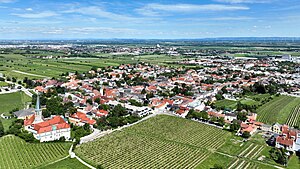
Gumpoldskirchen
Place in Lower Austria, Austria
Distance: Approx. 2388 meters
Latitude and longitude: 48.05,16.28333333
Gumpoldskirchen (Central Bavarian: Gumpoidskiachn) is a town in the district of Mödling in the Austrian state of Lower Austria. Gumpoldskirchen borders on the municipalities Mödling, Guntramsdorf, Gaaden, Pfaffstätten and Traiskirchen. The municipal area extends from the flats in the Vienna Basin to forest areas of the Anninger in the Vienna Woods.

Guntramsdorf
Place in Lower Austria, Austria
Distance: Approx. 705 meters
Latitude and longitude: 48.05,16.31666667
Guntramsdorf is a town in the district of Mödling in the Austrian state of Lower Austria. As part of the "Industrieviertel", the industrial region in the southeast of Lower Austria, it is well connected to the country capital Vienna. The local rail service Badner Bahn connects Guntramsdorf with the central district of Vienna in the north and popular spa resort destination Baden bei Wien in the south.

Wiener Neudorf
Place in Lower Austria, Austria
Distance: Approx. 4394 meters
Latitude and longitude: 48.08333333,16.31666667
Wiener Neudorf (Central Bavarian: Weana Neiduaf) is an Austrian town in the eastern part of the Mödling district, south of Vösendorf and Maria Enzersdorf, west of Biedermannsdorf, and north of Guntramsdorf.

Wiener Neustadt Canal
Distance: Approx. 4385 meters
Latitude and longitude: 48.07527778,16.34972222
The Wiener Neustadt Canal was Austria's only shipping canal, originally meant to reach from Vienna to Trieste's harbor to the Adriatic Sea. It became operational in 1803, and eventually covered 60 kilometres with 50 locks and a change in altitude of 103 metres between Vienna and Wiener Neustadt, where it terminated. Its eight bridges (built in the classical style) constitute Austria's oldest bridge ensemble.

Novomatic
Austrian gambling company
Distance: Approx. 1694 meters
Latitude and longitude: 48.0364,16.2943
Novomatic is an international gambling company based in Austria, founded by Johann Graf in 1980. Novomatic operates about 2,000 casinos and other gaming facilities in about 50 countries, many of them under the Admiral Casino brand. It also offers online gambling, and produces slot machines and other technology for the gaming industry.
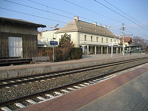
Gumpoldskirchen railway station
Railway station in Lower Austria
Distance: Approx. 2163 meters
Latitude and longitude: 48.04138889,16.28527778
Gumpoldskirchen is a railway station in the town of Gumpoldskirchen in Lower Austria.

Guntramsdorf-Thallern railway station
Railway station in Lower Austria
Distance: Approx. 1528 meters
Latitude and longitude: 48.05222222,16.29777778
Guntramsdorf-Thallern is a railway station serving the town of Guntramsdorf in Lower Austria.
Weather in this IP's area
heavy intensity rain
11 Celsius
11 Celsius
10 Celsius
12 Celsius
1017 hPa
92 %
1017 hPa
994 hPa
10000 meters
2.47 m/s
6.44 m/s
297 degree
100 %
06:33:32
19:05:42