Country:
 Austria
Region:
City:
Latitude and Longitude:
Time Zone:
Postal Code:
IP information under different IP Channel
ip-api
Country
Region
City
ASN
Time Zone
ISP
Blacklist
Proxy
Latitude
Longitude
Postal
Route
IPinfo
Country
Region
City
ASN
Time Zone
ISP
Blacklist
Proxy
Latitude
Longitude
Postal
Route
MaxMind
Country
Region
City
ASN
Time Zone
ISP
Blacklist
Proxy
Latitude
Longitude
Postal
Route
Luminati
Country
ATASN
Time Zone
Europe/Vienna
ISP
MMC GmbH
Latitude
Longitude
Postal
db-ip
Country
Region
City
ASN
Time Zone
ISP
Blacklist
Proxy
Latitude
Longitude
Postal
Route
ipdata
Country
Region
City
ASN
Time Zone
ISP
Blacklist
Proxy
Latitude
Longitude
Postal
Route
Popular places and events near this IP address
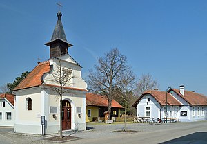
Mauerbach
Place in Lower Austria, Austria
Distance: Approx. 6883 meters
Latitude and longitude: 48.24166667,16.17638889
Mauerbach is a town on the western boundary of Vienna, Austria.

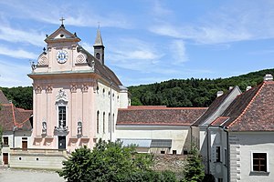
Mauerbach Charterhouse
Former monastery in Lower Austria, Austria
Distance: Approx. 5744 meters
Latitude and longitude: 48.25083333,16.16722222
Mauerbach Charterhouse (German: Kartause Mauerbach), in Mauerbach on the outskirts of Vienna, Austria, is a former Carthusian monastery, or charterhouse. Founded in 1314 and rebuilt in the 17th and 18th centuries, the Baroque monastic complex is one of the most important structures of its kind in Austria. Since 1984 the former charterhouse has been undergoing restoration by the Austrian Federal Monuments Office ("Österreichischer Bundesdenkmalamt" or BDA), which has its workshops there.

Judenau-Baumgarten
Place in Lower Austria, Austria
Distance: Approx. 5653 meters
Latitude and longitude: 48.28333333,16.02583333
Judenau-Baumgarten is a market town in the district of Tulln in the Austrian state of Lower Austria.

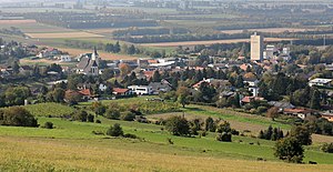
Königstetten
Place in Lower Austria, Austria
Distance: Approx. 1226 meters
Latitude and longitude: 48.28333333,16.11666667
Königstetten is a municipality in the district of Tulln in the Austrian state of Lower Austria.
Muckendorf-Wipfing
Place in Lower Austria, Austria
Distance: Approx. 6771 meters
Latitude and longitude: 48.32972222,16.15111111
Muckendorf-Wipfing is a municipality in the district of Tulln in the Austrian state of Lower Austria. On the south bank of the Danube, it is around 20 km northwest of Vienna.
Tulbing
Place in Lower Austria, Austria
Distance: Approx. 1489 meters
Latitude and longitude: 48.2875,16.11666667
Tulbing is a municipality in the district of Tulln in the Austrian state of Lower Austria. Tulbing is known for its rural landscape.

Gablitz
Place in Lower Austria, Austria
Distance: Approx. 6740 meters
Latitude and longitude: 48.22583333,16.14666667
Gablitz is a municipality in the district of St. Pölten-Land in the Austrian state of Lower Austria. It belonged to Wien-Umgebung which was dissolved in 2016.
Brumowski Air Base
Airport in Tulln / Vienna, Austria
Distance: Approx. 4803 meters
Latitude and longitude: 48.32111111,16.11194444
Fliegerhorst Leopold Figl – Flugplatz General Pabisch (Figl Air Base) is an Austrian Air Force (German: Österreichische Luftstreitkräfte) base located approximately 5 km (3 mi) east-southeast of Tulln; about 30 km (19 mi) northwest of Vienna. Figl Air Base is the headquarters of the Luftunterstützungsgeschwader (Air Support Wing). As of mid 2024 the Air Support Wing consists of a medium transport helicopter squadron Sikorsky S-70A-42 Black Hawk, a multi-purpose transport helicopter squadron Bell OH-58B Kiowa, a training and multi-purpose helicopter squadron AgustaWestland AW-169B Lion as well as a fixed-wing squadron Pilatus PC-6 B2H2 Turbo Porter, an air reconnaissance squadron and the ground organization required for flight operations.

Aubad
Artificial lake in Tulln an der Donau, Lower Austria
Distance: Approx. 6339 meters
Latitude and longitude: 48.333,16.077
The Aubad is a 50,000-square-metre (12-acre) man-made lake in Tulln on the Danube, Austria. It is the centerpiece of a recreational park (Erholungspark) that includes facilities for swimming, as well as a 10-hectare (25-acre) area for sport and leisure activities—such as soccer, volleyball, baseball and basketball—and 15 hectares (37 acres) of woodland. The lake and park are popular summertime resorts for both townspeople and tourists.

Comagena
Fortified Roman camp on the Danube, Austria
Distance: Approx. 6899 meters
Latitude and longitude: 48.3328,16.0569
Comagena was a fortified Roman camp on the Danube, on the site of the modern town of Tulln on the Danube in Lower Austria, Austria. Built as a defensive work along the Norican frontier, it originally housed an ala of up to 500 cavalry troops (ala I Commagenorum). From its exposed situation, it was able to guard a militarily significant ford over the Danube and control the valley lowlands for a good distance upstream and down.

Egon-Schiele-Museum
Museum in Tulln, Austria
Distance: Approx. 7061 meters
Latitude and longitude: 48.333,16.053
The Egon-Schiele-Museum is a museum in Tulln, Lower Austria dedicated to the Austrian painter Egon Schiele, who was born in Tulln.

Tulln-Langenlebarn Airfield Circuit
Airfield circuit, Tulln an der Donau, Austria
Distance: Approx. 4803 meters
Latitude and longitude: 48.32111111,16.11194444
Tulln-Langenlebarn Airfield Circuit was a 2.864 km (1.780 mi) former airfield circuit located on the Brumowski Air Base in Tulln an der Donau, was 33 km (21 mi) northwest of Vienna. The circuit was opened in October 1966 for national sports car race, then it also hosted races of European Formula Two Championship until September 1971. The circuit was closed due to the venue change of Formula Two race in 1972 to Österreichring.
Weather in this IP's area
scattered clouds
15 Celsius
14 Celsius
14 Celsius
17 Celsius
1017 hPa
65 %
1017 hPa
991 hPa
10000 meters
7.72 m/s
100 degree
40 %
07:19:50
18:01:12