Country:
Region:
City:
Latitude and Longitude:
Time Zone:
Postal Code:
IP information under different IP Channel
ip-api
Country
Region
City
ASN
Time Zone
ISP
Blacklist
Proxy
Latitude
Longitude
Postal
Route
Luminati
Country
Region
eng
City
coventry
ASN
Time Zone
Europe/London
ISP
UK Dedicated Servers Limited
Latitude
Longitude
Postal
IPinfo
Country
Region
City
ASN
Time Zone
ISP
Blacklist
Proxy
Latitude
Longitude
Postal
Route
db-ip
Country
Region
City
ASN
Time Zone
ISP
Blacklist
Proxy
Latitude
Longitude
Postal
Route
ipdata
Country
Region
City
ASN
Time Zone
ISP
Blacklist
Proxy
Latitude
Longitude
Postal
Route
Popular places and events near this IP address
Herbert Media
Distance: Approx. 157 meters
Latitude and longitude: 52.4072,-1.5063
Herbert Media is the in-house media service at the Herbert Art Gallery and Museum in Coventry, England. It manages recording studios, video editing rooms and training rooms, and produces much of the audio and visual sequences for the museum's exhibitions and permanent displays. Herbert Media was formerly known as the Depot Studios.

Herbert Art Gallery and Museum
Museum and art gallery in Coventry, England
Distance: Approx. 166 meters
Latitude and longitude: 52.407159,-1.506098
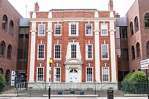
Herbert Art Gallery & Museum (also known as the Herbert) is a museum, art gallery, records archive, learning centre, media studio and creative arts facility on Jordan Well, Coventry, England.
Coventry Castle
Former castle in England
Distance: Approx. 117 meters
Latitude and longitude: 52.407442,-1.507933
Coventry Castle (grid reference SP336788) was a motte and bailey castle in the city of Coventry, England. It was demolished in the late 12th century and St Mary's Guildhall was built on part of the site.

Golden Cross, Coventry
Building in Coventry, West Midlands
Distance: Approx. 158 meters
Latitude and longitude: 52.4078,-1.5086
The Golden Cross is one of the oldest pubs in Coventry, West Midlands, and one of the longest-established alcohol-serving venues in England.

St Mary's Guildhall
Historic building in Coventry, England
Distance: Approx. 147 meters
Latitude and longitude: 52.4077,-1.5078
St Mary's Hall is a municipal building in Bayley Lane in Coventry, West Midlands, England. It is a Grade I listed building.

Ford's Hospital
Hospital in England
Distance: Approx. 156 meters
Latitude and longitude: 52.4064,-1.5105
Ford's Hospital, Coventry, traditionally known as Grey Friars Hospital, is a grade I listed 16th century half-timbered almshouse in Greyfriars Lane, Coventry. It was founded by the merchant William Ford (or perhaps 'Fourd') in 1509 to provide accommodation for six elderly people: five men and one woman. Despite the earlier name of "Grey Friars", it bears no relationship to the Franciscan Order but was so named because of its location on Greyfriars Lane.
38–39 Bayley Lane
Remains of building in Coventry, England
Distance: Approx. 155 meters
Latitude and longitude: 52.40779,-1.50812
38–39 Bayley Lane is a former building, whose present-day site is accessible from the Herbert Art Gallery and Museum in Coventry, England. All that remains is the medieval undercroft, a fourteenth-century cellar that initially belonged to a wealthy merchant, who was a clothier. The undercroft is built with sandstone with a stone-ribbed vault for added security and strength.

Drapers' Hall, Coventry
Distance: Approx. 156 meters
Latitude and longitude: 52.40764,-1.50713
Drapers' Hall is a historic building (Grade II* listed) in the Cathedral Quarter of Coventry built in 1832 by the Drapers' Company, a large trading guild in Coventry. The present building is believed to the third guildhall on the site.

Kirby House, Coventry
Distance: Approx. 49 meters
Latitude and longitude: 52.40615,-1.5088
16 Little Park Street (also known as Kirby House) is a Georgian townhouse (Grade II* listed) in central Coventry, West Midlands, England. It is one of two remaining Georgian buildings on the street and three in the city centre (the other two being 7 Little Park Street and 11 Priory Row). The name Kirby House comes from Thomas Hulston Kirby, a solicitor and clerk to the county's magistrates, who bought it in 1874.

Council House, Coventry
Municipal building in Coventry, West Midlands, England
Distance: Approx. 91 meters
Latitude and longitude: 52.4072,-1.5079
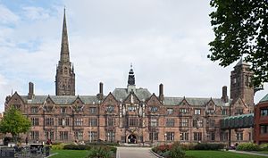
The Council House, Coventry in Coventry, England, is a Tudor Revival style city hall building which is the home of Coventry City Council and the seat of local government. It was built in the early 20th century. It is a Grade II-listed building.

22 Bayley Lane
Distance: Approx. 155 meters
Latitude and longitude: 52.40779,-1.50804
22 Bayley Lane (also known as The Cottage) is a grade II* listed building and only remaining mediaeval timber framed building in the Cathedral Quarter area of Coventry, where there were at one time a great many.
Coventry Combined Court Centre
Judicial building in Coventry, England
Distance: Approx. 157 meters
Latitude and longitude: 52.4057,-1.5062
The Coventry Combined Court Centre is a Crown Court venue, which deals with criminal cases, as well as a County Court venue, which deals with civil cases, in Much Park Street, Coventry, England.
Weather in this IP's area
drizzle
8 Celsius
8 Celsius
6 Celsius
9 Celsius
1026 hPa
95 %
1026 hPa
1015 hPa
7000 meters
1.03 m/s
100 %
07:19:03
16:21:02


