Country:
 Croatia
Region:
City:
Latitude and Longitude:
Time Zone:
Postal Code:
IP information under different IP Channel
ip-api
Country
Region
City
ASN
Time Zone
ISP
Blacklist
Proxy
Latitude
Longitude
Postal
Route
IPinfo
Country
Region
City
ASN
Time Zone
ISP
Blacklist
Proxy
Latitude
Longitude
Postal
Route
MaxMind
Country
Region
City
ASN
Time Zone
ISP
Blacklist
Proxy
Latitude
Longitude
Postal
Route
Luminati
Country
HRASN
Time Zone
Europe/Zagreb
ISP
CRATIS d.o.o.
Latitude
Longitude
Postal
db-ip
Country
Region
City
ASN
Time Zone
ISP
Blacklist
Proxy
Latitude
Longitude
Postal
Route
ipdata
Country
Region
City
ASN
Time Zone
ISP
Blacklist
Proxy
Latitude
Longitude
Postal
Route
Popular places and events near this IP address

Varaždin
City in Varaždin County, Croatia
Distance: Approx. 2013 meters
Latitude and longitude: 46.30805556,16.33777778
Varaždin (pronounced [ˈʋâraʒdiːn] or [ʋaˈrǎʒdin]; Hungarian: Varasd, also known by alternative names) is a city in Northern Croatia, 81 km (50 mi) north of Zagreb. The total population is 46,946, with 38,839 in the city settlement itself (2011). The city is best known for its baroque buildings, music, textile, food and IT industry.

Varaždin County (former)
Historic county of the Kingdom of Croatia-Slavonia
Distance: Approx. 2815 meters
Latitude and longitude: 46.3,16.33333333
Varaždin County (Croatian: Varaždinska županija; Hungarian: Varasd vármegye) was an administrative subdivision (županija) of the Kingdom of Croatia-Slavonia. Croatia-Slavonia was an autonomous kingdom within the Lands of the Crown of Saint Stephen (Transleithania), the Hungarian part of the dual Austro-Hungarian Empire. Its territory is now in northern Croatia.

Roman Catholic Diocese of Varaždin
Roman Catholic diocese in Croatia
Distance: Approx. 1966 meters
Latitude and longitude: 46.3078,16.3387
The Diocese of Varaždin (Latin: Dioecesis Varasdinensis) is a Latin ecclesiastical territory or diocese of the Catholic Church in northern Croatia. The diocese is centred in the city of Varaždin. It is a new diocese, having only been erected on July 5, 1997, from the Archdiocese of Zagreb.

Stadion Varteks
Football stadium in Croatia
Distance: Approx. 2904 meters
Latitude and longitude: 46.2933,16.3443
Stadion Varteks is a football stadium in Varaždin, Croatia. It is the home ground of the Croatian Football League club NK Varaždin and the lower division club NK Varteks. The stadium was built in 1931 as the home ground for a different NK Varaždin team, which overlapped with the current tenant with a similar name until its disbandment in 2015.
Trnovec Bartolovečki
Municipality in Varaždin County, Croatia
Distance: Approx. 3829 meters
Latitude and longitude: 46.29472222,16.39888889
Trnovec Bartolovečki is a municipality in Varaždin County, Croatia. The total population of the municipality in the 2011 census was 6,884, in the following villages (settlements): Bartolovec, population 749 Šemovec, population 916 Štefanec, population 412 Trnovec, population 4,185 Zamlaka, population 445 Žabnik, population 177 In the same census, over 99% the people living in the municipality were Croats. The village of Trnovec is located around 6 kilometres from the centre of Varaždin, the county seat of Varaždin County.
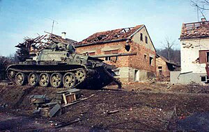
Battle of the Barracks
Part of the Croatian War of Independence
Distance: Approx. 2660 meters
Latitude and longitude: 46.309,16.328
The Battle of the Barracks (Croatian: Bitka za vojarne) was a series of engagements that occurred in mid-to-late 1991 between the Croatian National Guard (ZNG, later renamed the Croatian Army) and the Croatian police on one side and the Yugoslav People's Army (JNA) on the other. The battle took place around numerous JNA posts in Croatia, starting when Croatian forces blockaded the JNA barracks, weapons storage depots and other facilities. It formally began on 14 September; its objective was to neutralise the JNA positions in ZNG-held territory and to secure arms and ammunition supplies for the poorly equipped ZNG. The Battle of the Barracks was an escalation of the conflict between Croatian authorities and the Croatian Serbs who openly revolted in August 1990 and the JNA's efforts to preserve the Yugoslav federation.

Varaždin Arena
Distance: Approx. 35 meters
Latitude and longitude: 46.3169843,16.3610673
The Varaždin Arena is a multi-use indoor arena in Varaždin, Croatia. It is used mostly for team handball, volleyball and basketball games. The stadium has a capacity of 5,000 and was officially opened on 6 December 2008.
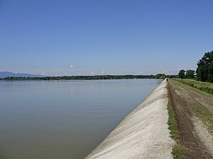
Lake Varaždin
Reservoir in Varaždin County, Croatia
Distance: Approx. 3022 meters
Latitude and longitude: 46.31666667,16.4
Lake Varaždin (Croatian: Varaždinsko jezero) is a reservoir on the Drava in northern Croatia. It is administratively divided between Međimurje County and Varaždin County, bordered by the municipalities of Varaždin, Trnovec Bartolovečki and Čakovec. The Drava flows into the reservoir near the city of Varaždin, while the dam is located near the village of Šemovec.

Church of St. George, Varaždin
Church in Varaždin, Croatia
Distance: Approx. 1814 meters
Latitude and longitude: 46.31013889,16.33916667
The Church of St. George in Varaždin is Serbian Orthodox church in Croatia. The church is dedicated to Saint George.
Kućan Marof
Village in Varaždin County, Croatia
Distance: Approx. 3059 meters
Latitude and longitude: 46.29055556,16.3725
Kućan Marof is a village in northern Croatia, located southeast of Varaždin. The population of the village in the 2011 census was 1,309.
Siege of Varaždin Barracks
Croatian National Guard siege during the Croatian War of Independence
Distance: Approx. 1923 meters
Latitude and longitude: 46.304618,16.342974
The siege of Varaždin Barracks, also referred to locally as Varaždin's days of war (Croatian: Varaždinski dani rata), was the blockade and capture of the Yugoslav People's Army (JNA) barracks and other facilities in and around the city of Varaždin during the Croatian War of Independence. The blockade began on 14 September 1991, quickly escalated into fighting, and ended on 22 September with the surrender of the JNA garrison. It was part of the Battle of the Barracks—an effort by Croatian armed forces to isolate JNA units based at barracks in Croatia, or capture the barracks to provide arms for Croatia's nascent army.
Cathedral of the Assumption of the Virgin Mary, Varaždin
Church in Varaždin, Croatia
Distance: Approx. 1970 meters
Latitude and longitude: 46.3075,16.3389
The Cathedral of the Assumption of the Virgin Mary (Croatian: Katedrala Uznesenja Blažene Djevice Marije na nebo) also called Varaždin Cathedral It is a Catholic church located in Varaždin, Croatia. The church is from 1997, the cathedral of the Diocese of Varaždin. Varazdin Cathedral was built in Baroque style between 1642 and 1646 by the Jesuit order.
Weather in this IP's area
broken clouds
22 Celsius
21 Celsius
19 Celsius
22 Celsius
1022 hPa
63 %
1022 hPa
1002 hPa
10000 meters
3.43 m/s
5.13 m/s
73 degree
57 %
06:39:11
18:56:43