Country:
 Turkey
Region:
City:
Latitude and Longitude:
Time Zone:
Postal Code:
IP information under different IP Channel
ip-api
Country
Region
City
ASN
Time Zone
ISP
Blacklist
Proxy
Latitude
Longitude
Postal
Route
IPinfo
Country
Region
City
ASN
Time Zone
ISP
Blacklist
Proxy
Latitude
Longitude
Postal
Route
MaxMind
Country
Region
City
ASN
Time Zone
ISP
Blacklist
Proxy
Latitude
Longitude
Postal
Route
Luminati
Country
TRASN
Time Zone
Europe/Istanbul
ISP
Onur Bilisim Ve Yazilim Hizmetleri
Latitude
Longitude
Postal
db-ip
Country
Region
City
ASN
Time Zone
ISP
Blacklist
Proxy
Latitude
Longitude
Postal
Route
ipdata
Country
Region
City
ASN
Time Zone
ISP
Blacklist
Proxy
Latitude
Longitude
Postal
Route
Popular places and events near this IP address

Etimesgut
District and municipality in Ankara, Turkey
Distance: Approx. 3887 meters
Latitude and longitude: 39.94583333,32.66944444
Etimesgut, formerly Ahimesut, is a municipality and metropolitan district of Ankara Province, Turkey. Its area is 273 km2, and its population is 614,891 (2022). It mainly consists of large public housing projects, 25 km (16 mi) from Ankara city centre.
Eryaman, Etimesgut
Neighbourhood in Etimesgut, Ankara, Turkey
Distance: Approx. 3888 meters
Latitude and longitude: 39.96666667,32.61666667
Eryaman is a neighbourhood in the municipality and district of Etimesgut, Ankara Province, Turkey. Its population is 30,275 (2022). It is located 28 km west of the city centre of Ankara.

Etimesgut Air Base
Airport in Ankara, Turkey
Distance: Approx. 4191 meters
Latitude and longitude: 39.94983056,32.68862222
Etimesgut Air Base (IATA: ANK, ICAO: LTAD) (Turkish: Etimesgut Hava Üssü) is an airbase of the Turkish Air Force located 15 km (9.3 mi) west of Ankara, Turkey. It is owned by Turkish Air Force and jointly operated by the air force and the Turkish Aeronautical Association (Turkish: Türk Hava Kurumu) (THK). International Defense Industry, Aerospace and Maritime Fair (IDEF) and civil aviation airshows are being held at this airport.
Ankara 75th Anniversary Race Course
Distance: Approx. 2298 meters
Latitude and longitude: 39.96942,32.68218
Ankara 75th Anniversary Race Course (Turkish: Ankara 75. Yıl Hipodromu) is a horse racing track located at Batıkent neighborhood in Yenimahalle district of Ankara, Turkey. It is founded in 1998, which was the 75th anniversary of Turkish Republic's foundation.

Etimesgut YHT Maintenance Facility
Distance: Approx. 3433 meters
Latitude and longitude: 39.959132,32.629037
The Etimesgut High-speed rail maintenance facility (Turkish: Etimesgut Yüksek Hızlı Tren ana bakım deposu), officially known as the Main High-speed rail Maintenance Facility (Turkish: YHT Ana Bakım Deposu), is a passenger rail yard used exclusively for YHT high-speed train-sets in Ankara, Turkey. Located in the Etiler neighborhood in northwestern Etimesgut, it is the second largest rail yard in Turkey spanning over 64 hectares (160 acres). The yard contains a large high-speed rail maintenance shop together with a high-speed rail focused training facility for employees.
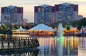
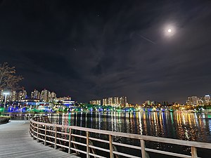
Göksu Park
Park that is located Eryaman, Ankara
Distance: Approx. 1476 meters
Latitude and longitude: 39.99024167,32.64823333
Göksu Park is a public park in Ankara, Turkey. Göksu Park is in Eryaman, a neighbourhood in the district of Etimesgut in Ankara. The park area is 50.8 ha (126 acres).

Eryaman Stadium
Football stadium in Eryaman district of Ankara, Turkey
Distance: Approx. 3840 meters
Latitude and longitude: 39.98027778,32.61388889
The Eryaman Stadium (Turkish: Eryaman Stadyumu) is a stadium in the Eryaman neighbourhood of Etimesgut, Ankara, Turkey. The construction began in 2016 and was completed in 2019. Gençlerbirliği and Ankaragücü use the stadium for home games.

Eryaman YHT railway station
Distance: Approx. 3629 meters
Latitude and longitude: 39.9556,32.6304
Eryaman YHT railway station (Turkish: Eryaman YHT garı), previously known as Ankara West YHT railway station (Turkish: Ankara Batı YHT garı), is a railway station in Ankara, Turkey. Once Başkentray commuter rail service begins in April, the station will become a transfer point between YHT high-speed trains and local commuter trains, replacing Sincan station. Eryaman station also replaced Emirler station, located about 175 m (574 ft) east of the station, which was demolished in July 2016.

Özgüneş railway station
Distance: Approx. 3234 meters
Latitude and longitude: 39.9518,32.6488
Özgüneş railway station (Turkish: Özgüneş istasyonu) is a railway station in Ankara, Turkey, currently being rebuilt. The station was a stop on the Ankara suburban from 1972 to 2016 when it was closed and demolished shortly after, in order to rebuild and expand the railway. Construction of the new station began in 2017 and is expected to open on 12 April 2018.
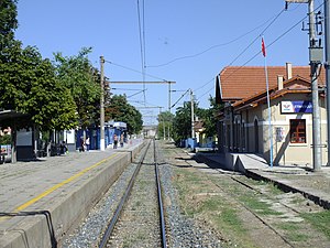
Etimesgut railway station
Distance: Approx. 3434 meters
Latitude and longitude: 39.9491,32.6628
Etimesgut railway station (Turkish: Etimesgut istasyonu) is a railway station in Etimesgut, Ankara, currently under renovation. The station was a stop on the Ankara suburban from 1972 to 2016, when the station was closed for renovation. Once the rebuilt station is opened, commuter rail service will resume.

Mesa (Ankara Metro)
Distance: Approx. 3888 meters
Latitude and longitude: 39.971667,32.703222
Mesa, is an underground rapid transit station of the Ankara Metro. Currently, only one line is in operation at this station. The station was opened on 12 February 2014, the same day that the M3 line opened.
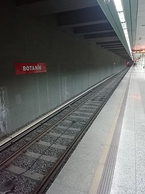
Botanik (Ankara Metro)
Distance: Approx. 3060 meters
Latitude and longitude: 39.980889,32.69475
Botanik, is an underground rapid transit station of the Ankara Metro. Currently, only one line is in operation at this station. The station was opened on 12 February 2014, the same day that the M3 line opened.
Weather in this IP's area
scattered clouds
25 Celsius
24 Celsius
24 Celsius
26 Celsius
1010 hPa
30 %
1010 hPa
919 hPa
10000 meters
5.14 m/s
250 degree
40 %
06:54:37
18:17:41