Country:
 Germany
Region:
City:
Latitude and Longitude:
Time Zone:
Postal Code:
IP information under different IP Channel
ip-api
Country
Region
City
ASN
Time Zone
ISP
Blacklist
Proxy
Latitude
Longitude
Postal
Route
IPinfo
Country
Region
City
ASN
Time Zone
ISP
Blacklist
Proxy
Latitude
Longitude
Postal
Route
MaxMind
Country
Region
City
ASN
Time Zone
ISP
Blacklist
Proxy
Latitude
Longitude
Postal
Route
Luminati
Country
DERegion
mv
City
neubrandenburg
ASN
Time Zone
Europe/Berlin
ISP
neu-medianet GmbH
Latitude
Longitude
Postal
db-ip
Country
Region
City
ASN
Time Zone
ISP
Blacklist
Proxy
Latitude
Longitude
Postal
Route
ipdata
Country
Region
City
ASN
Time Zone
ISP
Blacklist
Proxy
Latitude
Longitude
Postal
Route
Popular places and events near this IP address
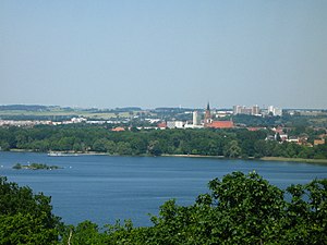
Neubrandenburg
City in Mecklenburg-Vorpommern, Germany
Distance: Approx. 1401 meters
Latitude and longitude: 53.55694444,13.26111111
Neubrandenburg (lit. New Brandenburg, IPA: [nɔʏˈbʁandn̩bʊʁk]) is a city in the southeast of Mecklenburg-Vorpommern, Germany. It is located on the shore of a lake called Tollensesee and forms the urban centre of the Mecklenburg Lakeland.

Camp Fünfeichen
World War II German prisoner-of-war camp
Distance: Approx. 3886 meters
Latitude and longitude: 53.5219,13.2918
Camp Fünfeichen (German: Lager Fünfeichen) was a World War II German prisoner-of-war camp located in Fünfeichen, a former estate within the city limits of Neubrandenburg, Mecklenburg, northern Germany. Built as Stalag II-A Neubrandenburg in 1939, it was extended by the officer camp Oflag II-E in 1940 (renamed Oflag-67, 1944). After the Soviet takeover in 1945 until 1949 it was used as special camp, NKVD-camp Nr.

Kulturfinger
Distance: Approx. 1481 meters
Latitude and longitude: 53.55805556,13.26027778
The Kulturfinger is the nickname of a steel-framed tower built during the days of the communist German Democratic Republic that is the tallest building in Neubrandenburg, Germany. It is part of the Haus der Kultur und Bildung (German for House of Culture and Education) or HKB, the city's cultural institution. The 56-m, 16-story mixed-use socialist realist building was designed by Neubrandenburg chief architect Iris Grund, who had studied under East Germany's prominent architect Hermann Henselmann.

Zirzow
Municipality in Mecklenburg-Vorpommern, Germany
Distance: Approx. 6025 meters
Latitude and longitude: 53.58333333,13.18333333
Zirzow is a municipality in the district Mecklenburgische Seenplatte, in Mecklenburg-Vorpommern, Germany.
Woggersin
Municipality in Mecklenburg-Vorpommern, Germany
Distance: Approx. 4668 meters
Latitude and longitude: 53.58333333,13.21666667
Woggersin is a municipality in the district of Mecklenburgische Seenplatte, in Mecklenburg-Vorpommern, Germany.

Trollenhagen
Municipality in Mecklenburg-Vorpommern, Germany
Distance: Approx. 4681 meters
Latitude and longitude: 53.58333333,13.28333333
Trollenhagen is a municipality in the district Mecklenburgische Seenplatte, in Mecklenburg-Vorpommern, in north-eastern Germany. Formerly the home of an East German Air Force base.
Neverin (Amt)
Distance: Approx. 4638 meters
Latitude and longitude: 53.583,13.283
Neverin is an Amt in the Mecklenburgische Seenplatte district, in Mecklenburg-Vorpommern, Germany. The seat of the Amt is in Neverin.
Tollensesee
Distance: Approx. 5038 meters
Latitude and longitude: 53.50722222,13.21138889
Tollensesee is a zungenbecken lake in Mecklenburg-Vorpommern, Germany. It belongs to the Mecklenburg Lake District. At an elevation of 14.8 m, its surface area is 17.4 km².

Linde (Tollense)
River in Germany
Distance: Approx. 1137 meters
Latitude and longitude: 53.55638889,13.2525
Linde is a river of Mecklenburg-Vorpommern, Germany. It is a right tributary of the Tollense.

Neubrandenburg station
Railway station in Germany
Distance: Approx. 1938 meters
Latitude and longitude: 53.56222222,13.26166667
Neubrandenburg (German: Bahnhof Neubrandenburg) is a railway station in the city of Neubrandenburg, Mecklenburg-Vorpommern, Germany. The station lies on the Stralsund-Neubrandenburg railway and Bützow–Szczecin railway and the train services are operated by Deutsche Bahn and Ostseeland Verkehr.
14th Panzergrenadier Division (Bundeswehr)
Military unit
Distance: Approx. 1933 meters
Latitude and longitude: 53.542373,13.278265
The 14th Panzergrenadier Division (14. Panzergrenadierdivision) was a German mechanized infantry formation. It was part of the Multinational Corps Northeast, a NATO corps that includes German, Polish, and Danish troops.

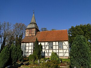
Marienkirche, Neubrandenburg
Distance: Approx. 1242 meters
Latitude and longitude: 53.55555556,13.26027778
Marienkirche (St. Mary's Church), a hall church in the North German red brick Gothic style, completed in 1298, was the main church of the city of Neubrandenburg. It has been transformed into a concert hall, designed by Pekka Salminen, which opened in 2001.
Weather in this IP's area
overcast clouds
13 Celsius
12 Celsius
13 Celsius
13 Celsius
1016 hPa
78 %
1016 hPa
1014 hPa
10000 meters
3.75 m/s
7.58 m/s
124 degree
100 %
07:39:58
18:03:54