Country:
Region:
City:
Latitude and Longitude:
Time Zone:
Postal Code:
IP information under different IP Channel
ip-api
Country
Region
City
ASN
Time Zone
ISP
Blacklist
Proxy
Latitude
Longitude
Postal
Route
Luminati
Country
ASN
Time Zone
Europe/Dublin
ISP
Internet Protocol Telecom Ltd
Latitude
Longitude
Postal
IPinfo
Country
Region
City
ASN
Time Zone
ISP
Blacklist
Proxy
Latitude
Longitude
Postal
Route
db-ip
Country
Region
City
ASN
Time Zone
ISP
Blacklist
Proxy
Latitude
Longitude
Postal
Route
ipdata
Country
Region
City
ASN
Time Zone
ISP
Blacklist
Proxy
Latitude
Longitude
Postal
Route
Popular places and events near this IP address

Macroom
Town in County Cork, Ireland
Distance: Approx. 717 meters
Latitude and longitude: 51.9047,-8.9597
Macroom (; Irish: Maigh Chromtha) is a market town in County Cork, Ireland, located in the valley of the River Sullane, halfway between Cork city and Killarney. Its population has grown and receded over the centuries as it went through periods of war, famine and workhouses, forced emigration and intermittent prosperity. The 2011 census gave an urban population of 3,879 people, while the 2016 census recorded 3,765 people.
Battle of Macroom
Battle during Cromwell's conquest of Ireland in 1650
Distance: Approx. 910 meters
Latitude and longitude: 51.904354,-8.956947
The Battle of Macroom was a skirmish fought on 10 May 1650, near Macroom, County Cork, in southern Ireland, during the Cromwellian conquest of Ireland. An English Parliamentarian force under Roger Boyle, (Lord Broghill), defeated an Irish Confederate force under David Roche.

Carrigaphooca Castle
14th century ruined tower house in County Cork, Ireland
Distance: Approx. 4039 meters
Latitude and longitude: 51.9086,-9.0284
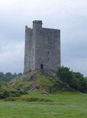
Carrigaphooca Castle (Irish: Caisleán Charraig a' Phúca meaning "castle on the rock of the fairy"; the word púca translates as ghost or fairy) is a ruined five storey rectangular tower house situated on a steep-sided rock overlooking the River Sullane. It is located 6 km west of Macroom, County Cork, Ireland, in an area once known as Gleann na n-Dearg ("valley of the reds"). The tower dominates the landscape of Lissacresig (Fairyland) in Clondrohid, and Lower Shanballyshane, in Kilnamartyra.

Clondrohid
Village in County Cork, Ireland
Distance: Approx. 4396 meters
Latitude and longitude: 51.92916667,-9.02222222
Clondrohid (Irish: Cluain Droichead, meaning 'meadow of the bridge') is a village and civil parish in County Cork, Ireland, four miles (6 km) north of Macroom. As of the 2022 census, the population of the village was recorded as 180, down slightly from 188 people as of the 2011 census.
Macroom GAA
Gaelic sports club in County Cork, Ireland
Distance: Approx. 508 meters
Latitude and longitude: 51.90314722,-8.97451111
Macroom GAA is a Gaelic football and hurling club based in the town and surrounding parish of Macroom in Cork, Ireland. The club is affiliated with Cork GAA county board and the Muskerry GAA divisional board. The club has been one of the most successful Gaelic football clubs in Cork having won the Cork Senior Football Championship ten times and having contributed numerous players to Cork GAA football teams.

Macroom Castle
Castle in Macroom, County Cork, Ireland
Distance: Approx. 333 meters
Latitude and longitude: 51.90583333,-8.965
Macroom Castle, in the centre of the town of Macroom, was once residence and fortress of the Lords of Muskerry. The castle has changed owners many times, has been besieged, burned, and rebuilt. The MacCarthys of Muskerry owned it with some interruptions from about 1353 when Muskerry was given to Dermot MacCarthy, 1st Lord of Muskerry, until 1691 when Donogh MacCarthy, 4th Earl of Clancarty lost it definitively.

Carrigadrohid Lake
Reservoir on the River Lee, Ireland
Distance: Approx. 6476 meters
Latitude and longitude: 51.897162,-8.876642
Carrigadrohid Lake (Irish: Loch Charraig an Droichid) is a lake on the River Lee in County Cork, in the province of Munster, in the south of Ireland. Situated upstream (westward) of Carrigadrohid village, the lake is actually a reservoir, created for the Carrigadrohid hydroelectric power station, which was erected in the 1950s. The lake also serves as a fishery for bream, rudd, roach, northern pike and perch.
Lissacresig Ringfort
Ringfort in County Cork, Ireland
Distance: Approx. 6236 meters
Latitude and longitude: 51.924359,-9.055811
Lissacresig is a ringfort (rath) and National Monument (#571) located in County Cork, Ireland.
Carrigaphooca Stone Circle
Stone circle in County Cork, Ireland
Distance: Approx. 3813 meters
Latitude and longitude: 51.90959,-9.02499
Carrigaphooca Stone Circle is a stone circle and National Monument located in County Cork, Ireland. It is situated 4.4 km (2.7 mi) west of Macroom, immediately east of Carrigaphooca Castle, north of the N22, and near the confluence of the River Sullane and River Foherish. The name means "stone of the púca" (ghost or fairy).
Carrigadrohid hydroelectric power station
Dam in County Cork, Ireland
Distance: Approx. 7346 meters
Latitude and longitude: 51.897175,-8.86382
Carrigadrohid hydroelectric power station is a hydroelectric plant located on the River Lee in County Cork, Ireland. It is owned and operated by the ESB Group. The dam is 130 m (427 ft) long and has a single 8 MW (11,000 hp) Kaplan turbine which produces an average of 22 GWh (79 TJ) each year.

Macroom Mountain Dew Festival
Music festival in Ireland
Distance: Approx. 532 meters
Latitude and longitude: 51.90517,-8.96229
Macroom Mountain Dew Festival was a music festival in Ireland, which was held between 1976 and 1982. Taking place in the grounds of a 19th-century castle in County Cork, it is considered to have been the first rock festival in Ireland.

Macroom Town Hall
Municipal building in Macroom, County Cork, Ireland
Distance: Approx. 711 meters
Latitude and longitude: 51.9047,-8.9598
Macroom Town Hall (Irish: Halla an Bhaile Maigh Chromtha) is a municipal building in West Square at Macroom, County Cork, Ireland. It is currently used by Cork County Council for the delivery of local services.
Weather in this IP's area
overcast clouds
11 Celsius
11 Celsius
11 Celsius
11 Celsius
1020 hPa
96 %
1020 hPa
1007 hPa
10000 meters
3.91 m/s
9.24 m/s
117 degree
96 %
07:36:25
17:02:27
