Country:
 Great Britain
Region:
City:
Latitude and Longitude:
Time Zone:
Postal Code:
IP information under different IP Channel
ip-api
Country
Region
City
ASN
Time Zone
ISP
Blacklist
Proxy
Latitude
Longitude
Postal
Route
IPinfo
Country
Region
City
ASN
Time Zone
ISP
Blacklist
Proxy
Latitude
Longitude
Postal
Route
MaxMind
Country
Region
City
ASN
Time Zone
ISP
Blacklist
Proxy
Latitude
Longitude
Postal
Route
Luminati
Country
GBASN
Time Zone
Europe/London
ISP
Node4 Hosting Limited
Latitude
Longitude
Postal
db-ip
Country
Region
City
ASN
Time Zone
ISP
Blacklist
Proxy
Latitude
Longitude
Postal
Route
ipdata
Country
Region
City
ASN
Time Zone
ISP
Blacklist
Proxy
Latitude
Longitude
Postal
Route
Popular places and events near this IP address
St Augustine's High School, Edinburgh
Secondary school in Edinburgh, Scotland
Distance: Approx. 540 meters
Latitude and longitude: 55.93305556,-3.28861111
St. Augustine's High School, established in 1969, is a Roman Catholic secondary school serving the west of Edinburgh, Scotland, with approximately 840 pupils.
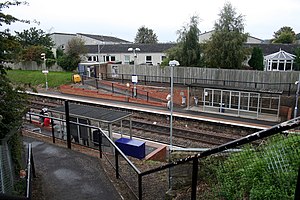
South Gyle railway station
Railway station in Edinburgh, Scotland
Distance: Approx. 887 meters
Latitude and longitude: 55.9366,-3.2998
South Gyle railway station is a railway station serving South Gyle in the City of Edinburgh, Scotland. The station was opened on 9 May 1985 by ScotRail alongside new housing in the area, and is located on the Fife Circle Line, 4+1⁄2 miles (7.2 km) west of Edinburgh Waverley. It has two platforms.

South Gyle
District of Edinburgh, Scotland
Distance: Approx. 656 meters
Latitude and longitude: 55.93481944,-3.29780833
South Gyle (pronounced ) is an area of Edinburgh, Scotland, lying on the western edge of the city and to the south and west of an area of former marshland once known as the Gogarloch, on the edge of Corstorphine. Most of the buildings in the area are of recent origin, dating from the later 1980s, 1990s, and early 21st century, with the exception of some farm workers' cottages and an early 1970s council estate abutting South Gyle railway station. South Gyle can be neatly divided into two main zones – a residential one, incorporating Gogarloch and the neighbouring area centred on South Gyle Mains; and a commercial/business one which incorporates the Gyle Shopping Centre, Edinburgh Park, Gyle Park (an actual park, but with some shopping centres near it), and South Gyle Crescent.

Bankhead, Edinburgh
Human settlement in Scotland
Distance: Approx. 503 meters
Latitude and longitude: 55.92527778,-3.29777778
Bankhead is a non-residential area of western Edinburgh, Scotland. It borders the Edinburgh City Bypass (A720) and Hermiston Gait (M8 motorway terminus) to the west, the Calders neighbourhood to the south – accessed via a pedestrian underpass, Sighthill to the east, and South Gyle/Edinburgh Park to the north. It is mostly occupied by a large industrial park.
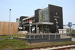
Edinburgh Park station
Railway station in Edinburgh, Scotland
Distance: Approx. 869 meters
Latitude and longitude: 55.9276,-3.3077
Edinburgh Park railway station is a railway station in the west of Edinburgh, Scotland, serving the Edinburgh Park business park and the Hermiston Gait shopping centre. The new station building was designed by IDP Architects, and it opened on 4 December 2003. It is the first intermediate station between Haymarket and Linlithgow since 1951.
Broomhouse, Edinburgh
Human settlement in Scotland
Distance: Approx. 833 meters
Latitude and longitude: 55.92833333,-3.28084722
Broomhouse is a district of Edinburgh, Scotland. Although on the lands of Old Saughton, its name is adopted from an estate which lay to the north of the Edinburgh and Glasgow Railway. The earliest recorded versions of the name (c.1600) were variations on Brum(e)hous.
Stevenson College, Edinburgh
Distance: Approx. 437 meters
Latitude and longitude: 55.92611111,-3.29
Stevenson College Edinburgh, was a further education college in Edinburgh, Scotland. It was founded in 1970, and was named after famous Scottish engineer, Robert Stevenson. In 2012 it merged with Telford College and Jewel & Esk College to form part of the newly established Edinburgh College.
Sighthill Stadium
Sports venue in City of Edinburgh, Scotland, UK
Distance: Approx. 668 meters
Latitude and longitude: 55.9258,-3.2854
Sighthill Stadium was a proposed stadium to be located in the Sighthill district of Edinburgh, Scotland. It would have been a multi-use stadium hosting a number of sports, principally athletics and rugby. Edinburgh Rugby were considered key potential tenants.
Forrester High School
Mixed secondary school in Edinburgh, Scotland
Distance: Approx. 470 meters
Latitude and longitude: 55.9317,-3.2879
Forrester High School is a secondary school in the west of Edinburgh, Scotland. St Augustine's High School, an RC secondary, moved onto a shared campus with Forrester High School in January 2010. Previously the schools had been next to each other.
Forrester, Edinburgh
Residential area in Edinburgh, Scotland, UK
Distance: Approx. 650 meters
Latitude and longitude: 55.93205,-3.28491
Forrester is a primarily residential area of Corstorphine, Edinburgh which has its own high school and rugby club. The closest railway stations are at South Gyle and Edinburgh Park, but it is itself wedged between the two railway lines. It is not to be confused with "Forrester Road", which is on the other side of Corstorphine on the slopes of Corstophine Hill.

St Joseph's Church, Edinburgh
Church in Broomhouse, Edinburgh
Distance: Approx. 817 meters
Latitude and longitude: 55.92912,-3.28101
St Joseph's Church, Sighthill, (also known as St Joseph's Broomhouse), is a Roman Catholic church situated in Broomhouse, in the west of Edinburgh, Scotland. The parish boundary extends to Broomhouse, Parkhead, Saughton, Sighthill, Gorgie and further.

National Collection of Aerial Photography
Archive in Edinburgh, Scotland
Distance: Approx. 700 meters
Latitude and longitude: 55.92361111,-3.29888889
The National Collection of Aerial Photography is a photographic archive in Edinburgh, Scotland, containing over 30 million aerial photographs of worldwide historic events and places. From 2008–2015 it was part of the Royal Commission on the Ancient and Historical Monuments of Scotland and since then it has been a sub-brand of Historic Environment Scotland. Many of the aerial reconnaissance photographs were taken during the Second World War and the Cold War, and were declassified and released by the Ministry of Defence.
Weather in this IP's area
clear sky
12 Celsius
12 Celsius
11 Celsius
13 Celsius
1012 hPa
82 %
1012 hPa
1006 hPa
10000 meters
6.26 m/s
12.52 m/s
205 degree
07:24:31
18:38:14