184.53.33.123 - IP Lookup: Free IP Address Lookup, Postal Code Lookup, IP Location Lookup, IP ASN, Public IP
Country:
Region:
City:
Location:
Time Zone:
Postal Code:
IP information under different IP Channel
ip-api
Country
Region
City
ASN
Time Zone
ISP
Blacklist
Proxy
Latitude
Longitude
Postal
Route
Luminati
Country
Region
ky
ASN
Time Zone
America/New_York
ISP
HNS-DIRECPC
Latitude
Longitude
Postal
IPinfo
Country
Region
City
ASN
Time Zone
ISP
Blacklist
Proxy
Latitude
Longitude
Postal
Route
IP2Location
184.53.33.123Country
Region
indiana
City
indianapolis
Time Zone
America/Indiana/Indianapolis
ISP
Language
User-Agent
Latitude
Longitude
Postal
db-ip
Country
Region
City
ASN
Time Zone
ISP
Blacklist
Proxy
Latitude
Longitude
Postal
Route
ipdata
Country
Region
City
ASN
Time Zone
ISP
Blacklist
Proxy
Latitude
Longitude
Postal
Route
Popular places and events near this IP address

Indianapolis
Capital and most populous city of Indiana, United States
Distance: Approx. 74 meters
Latitude and longitude: 39.76861111,-86.15805556
Indianapolis ( IN-dee-ə-NAP-ə-lis), colloquially known as Indy, is the capital and most populous city of the U.S. state of Indiana and the seat of Marion County. Indianapolis is situated in the state's central till plain region along the west fork of the White River. The city's official slogan, "Crossroads of America", reflects its historic importance as a transportation hub and its relative proximity to other major North American markets.

Indiana State School Music Association
Distance: Approx. 78 meters
Latitude and longitude: 39.7684,-86.1581
The Indiana State School Music Association, Inc. is a scholastic music association, with a mission to provide educationally evaluated music performance activities for the students and teachers of the state of Indiana, to assist in the development of performance-oriented assessment of state and national musical academic standards, and to offer educational support to fulfill this mission. The Northern Indiana School Band, Orchestra, and Vocal Association was integrated into the ISSMA in 1980.

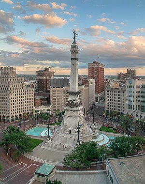
Soldiers' and Sailors' Monument (Indianapolis)
Monument and historic site in Indianapolis, Indiana, U.S.
Distance: Approx. 76 meters
Latitude and longitude: 39.76833333,-86.15805556
The Indiana State Soldiers and Sailors Monument is a 284 ft 6 in (86.72 m) tall neoclassical monument built on Monument Circle, a circular, brick-paved street that intersects Meridian and Market streets in the center of downtown Indianapolis, Indiana. In the years since its public dedication on May 15, 1902, the monument has become an iconic symbol of Indianapolis, the state capital of Indiana. It was added to the National Register of Historic Places on February 13, 1973, and was included in an expansion of the Indiana World War Memorial Plaza National Historic Landmark District in December 2016.

Area codes 317 and 463
Area codes that serve Indianapolis and most of its suburbs
Distance: Approx. 76 meters
Latitude and longitude: 39.768333,-86.158056
Area codes 317 and 463 are telephone area codes in the North American Numbering Plan (NANP) for Indianapolis and nine surrounding counties in central Indiana. The numbering plan area (NPA) comprises all or parts of Marion, Boone, Hancock, Hamilton, Hendricks, Johnson, Madison, Morgan, and Shelby counties. 317 is the original area code of the NPA, created in 1947, while 463 is an overlay code for the same area that was added in 2016, making ten-digit dialing mandatory for all calls in the region.

Christ Church Cathedral (Indianapolis)
Historic church in Indiana, United States
Distance: Approx. 79 meters
Latitude and longitude: 39.76916667,-86.1575
Christ Church Cathedral is the cathedral for the Episcopal Diocese of Indianapolis. Christ Church parish was formally organized in 1837. The present-day church building was erected in 1857 on Monument Circle at the center of downtown Indianapolis to replace the parish's first church built on the same site.

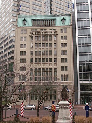
Fletcher Trust Building
High-rise hotel in Indianapolis, Indiana, U.S.
Distance: Approx. 61 meters
Latitude and longitude: 39.76868056,-86.15652778
Fletcher Trust Building, officially known as the Hilton Garden Inn Indianapolis Downtown, is a hotel high-rise in Indianapolis, Indiana. The building rises 16 floors and 218 feet (66 m) in height, and is currently the 22nd-tallest building in the city. The structure was completed in 1915.
EdChoice
Distance: Approx. 56 meters
Latitude and longitude: 39.769,-86.1571
EdChoice, formerly the Friedman Foundation for Educational Choice, is an American education reform organization headquartered in Indianapolis, Indiana. It was founded in 1996 by economist spouses Milton and Rose D. Friedman. The organization's mission is to advance "school choice for all children" nationwide.

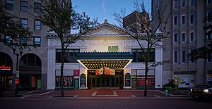
Hilbert Circle Theatre
Historic theater in Indianapolis, Indiana, U.S.
Distance: Approx. 50 meters
Latitude and longitude: 39.76805556,-86.15722222
The Hilbert Circle Theatre, originally called the Circle Theatre, is in Indianapolis, Indiana, on Monument Circle in the Washington Street-Monument Circle Historic District. It was originally built in 1916 as a "deluxe movie palace" and now is the home of the Indianapolis Symphony Orchestra.: 2–3 The theatre was listed on the National Register of Historic Places in 1980.
The Columbia Club
United States historic place
Distance: Approx. 79 meters
Latitude and longitude: 39.76916667,-86.1575
The Columbia Club is a private club located on Monument Circle in downtown Indianapolis, Indiana, United States. The club was founded in 1889 and the current structure was built in 1925 as the club's third home on the same site.

Washington Street–Monument Circle Historic District
Historic district in Indiana, United States
Distance: Approx. 109 meters
Latitude and longitude: 39.76777778,-86.15805556
Washington Street–Monument Circle Historic District is a national historic district located at Indianapolis, Indiana, United States, covering the first two blocks of East and West Washington and Market streets, the south side of the 100 block of East Ohio Street, Monument Circle, the first block of North and South Meridian Street, the first two blocks of North Pennsylvania Street, the west side of the first two blocks of North Delaware Street, the east side of the first block of North Capitol Avenue, and the first block of North Illinois Street. In total, the district encompasses 40 contributing buildings and 2 contributing structures in the central business district of Indianapolis centered on Monument Circle. It developed between about 1852 and 1946, and includes representative examples of Italianate, Greek Revival, and Art Deco style architecture.

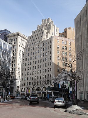
Circle Tower
Art Deco NRHP building in Indianapolis, Indiana
Distance: Approx. 28 meters
Latitude and longitude: 39.76827778,-86.15705556
Circle Tower is a 14-story high rise at 55 Monument Circle in Indianapolis, Indiana, United States. The building is a contributing property of the Washington Street–Monument Circle Historic District, which was listed in the National Register of Historic Places in 1997. The building was designed by Rubush & Hunter and is an example of Art Deco architecture.

Giorgio's Pizza
Italian restaurant in Indianapolis, Indiana, U.S.
Distance: Approx. 28 meters
Latitude and longitude: 39.7684,-86.1569
Giorgio's Pizza is a pizzeria in Indianapolis, in the U.S. state of Indiana. Giorgio and Bettina Migliaccio opened Giorgio's in 1990, near Monument Circle. Elif Ozdemir and George Stergiopoulos are the current co-owners.
Weather in this IP's area
overcast clouds
-2 Celsius
-8 Celsius
-3 Celsius
-1 Celsius
1020 hPa
76 %
1020 hPa
990 hPa
10000 meters
7.2 m/s
290 degree
100 %
