Country:
 USA
USARegion:
City:
Latitude and Longitude:
Time Zone:
Postal Code:
IP information under different IP Channel
ip-api
Country
Region
City
ASN
Time Zone
ISP
Blacklist
Proxy
Latitude
Longitude
Postal
Route
IPinfo
Country
Region
City
ASN
Time Zone
ISP
Blacklist
Proxy
Latitude
Longitude
Postal
Route
MaxMind
Country
Region
City
ASN
Time Zone
ISP
Blacklist
Proxy
Latitude
Longitude
Postal
Route
Luminati
Country
USRegion
ca
City
santarosa
ASN
Time Zone
America/Los_Angeles
ISP
AS-SONICTELECOM
Latitude
Longitude
Postal
db-ip
Country
Region
City
ASN
Time Zone
ISP
Blacklist
Proxy
Latitude
Longitude
Postal
Route
ipdata
Country
Region
City
ASN
Time Zone
ISP
Blacklist
Proxy
Latitude
Longitude
Postal
Route
Popular places and events near this IP address

Piner High School
Public secondary school in Santa Rosa, California , United States
Distance: Approx. 2446 meters
Latitude and longitude: 38.46194444,-122.76638889
Piner High School (PHS) is a Public high school in Santa Rosa, California, United States. It is part of the Santa Rosa High School District, which itself is part of Santa Rosa City Schools.
Cardinal Newman High School (Santa Rosa, California)
Private school in Santa Rosa, California, United States
Distance: Approx. 1855 meters
Latitude and longitude: 38.49416667,-122.74138889
Cardinal Newman High School is an American Catholic high school located in Santa Rosa, California. The school was originally for boys, but shared some facilities with Ursuline High School for girls; it has been coeducational since Ursuline's closure in 2011. Its colors are Cardinal Red and Gold; its mascot is the cardinal.
Empire College
Private college in Santa Rosa, California, US
Distance: Approx. 1971 meters
Latitude and longitude: 38.4679,-122.7291
Empire College is a private for-profit college in Santa Rosa, California. Founded in 1961, The college offers business and law degrees and was formerly accredited by the Accrediting Council for Independent Colleges and Schools (ACICS). However, in 2016 the United States Secretary of Education denied ACICS's accrediting status for failing to meet 21 recognition criteria.
Empire College School of Law
Distance: Approx. 2039 meters
Latitude and longitude: 38.4674,-122.7286
Empire College School of Law, part of Empire College and founded in 1973, is a four-year evening law school program approved by the Committee of Bar Examiners of the State Bar of California. As an evening-only law school, the School of Law is not accredited by the American Bar Association. As a result, graduates are generally only eligible to take the bar and practice law in California.

Fountaingrove Lake
Reservoir in Sonoma County, California
Distance: Approx. 2620 meters
Latitude and longitude: 38.48666667,-122.71944444
Fountaingrove Lake is a reservoir in the city of Santa Rosa, California, United States. Formed by the Fountaingrove Dam, the lake is fed from the east by Piner Creek, which is also the lake's sole outlet. Fountaingrove Dam is an earthen dam built in 1953.
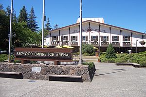
Snoopy's Home Ice
Distance: Approx. 2239 meters
Latitude and longitude: 38.4609,-122.7344
The Redwood Empire Ice Arena (commonly known as Snoopy's Home Ice) is an indoor ice rink in Santa Rosa, California, United States. It was owned and built by Peanuts cartoonist Charles M. Schulz, and it opened on April 28, 1969. It was originally conceived, designed, and operated by his first wife Joyce Schulz.
Ursuline High School (Santa Rosa, California)
Private, all-female school in Santa Rosa, , California, United States
Distance: Approx. 1849 meters
Latitude and longitude: 38.49416667,-122.74166667
Ursuline High School was a private, Roman Catholic, all-girls college-preparatory high school in Santa Rosa, California, in the Diocese of Santa Rosa. It was owned and operated by the Ursuline Sisters of the Roman Union from 1880 to 2011, and was a sister school to Cardinal Newman High School for boys.

Charles M. Schulz Museum and Research Center
American museum
Distance: Approx. 2299 meters
Latitude and longitude: 38.45999444,-122.73504167
The Charles M. Schulz Museum and Research Center is a museum dedicated to the works of Charles M. Schulz, creator of the Peanuts comic strip. The museum opened on August 17, 2002, two years after Schulz died, and is in Santa Rosa, California. The museum is home to many of the original Peanuts strips, as well as other artwork by Schulz.
Moonlight Brewing Company
Distance: Approx. 731 meters
Latitude and longitude: 38.47167222,-122.74656667
The Moonlight Brewing Company is a brewery founded in 1992 by Brian Hunt in Santa Rosa, California, USA. It is best known for its flagship beers, Death & Taxes Black Beer and Reality Czeck-style Pilsner, which are popular in Sonoma County, California. In 2008, it received the Best Brewery award at the 17th annual Santa Rosa Beerfest.

Luther Burbank Center for the Arts
Performing arts venue in Santa Rosa, California
Distance: Approx. 1676 meters
Latitude and longitude: 38.4932,-122.7492
The Luther Burbank Center for the Arts (sometimes called the LBC), and previously known as the Wells Fargo Center for the Arts from March 2005 to March 2016) is a performance venue located just north of Santa Rosa, California, near U.S. 101. The facility is owned and operated by the Luther Burbank Memorial Foundation, a non-profit arts organization established in 1979.

Coddingtown Mall
Shopping mall in Santa Rosa, California
Distance: Approx. 2738 meters
Latitude and longitude: 38.457778,-122.73
Coddingtown Mall is an enclosed shopping mall in Santa Rosa, California, United States. Opened in 1962, the mall is anchored by JCPenney, Macy's, Nordstrom Rack, Target, and Whole Foods Market. It is fully owned and operated by Codding Enterprises.

Santa Rosa North station
Distance: Approx. 2724 meters
Latitude and longitude: 38.4553,-122.7365
Santa Rosa North station (known as Santa Rosa–Guerneville Road during planning) is a Sonoma–Marin Area Rail Transit train station in Santa Rosa. It opened to preview service on July 1, 2017; full commuter service commenced on August 25, 2017. The station is located on Guerneville Road 0.3 miles (0.5 km) west of the Coddingtown Mall.
Weather in this IP's area
clear sky
23 Celsius
23 Celsius
20 Celsius
28 Celsius
1010 hPa
58 %
1010 hPa
1005 hPa
10000 meters
4.63 m/s
170 degree
06:56:36
19:12:37