Country:
 USA
USARegion:
City:
Latitude and Longitude:
Time Zone:
Postal Code:
IP information under different IP Channel
ip-api
Country
Region
City
ASN
Time Zone
ISP
Blacklist
Proxy
Latitude
Longitude
Postal
Route
Luminati
Country
USRegion
ca
City
berkeley
ASN
Time Zone
America/Los_Angeles
ISP
AS-SONICTELECOM
Latitude
Longitude
Postal
IPinfo
Country
Region
City
ASN
Time Zone
ISP
Blacklist
Proxy
Latitude
Longitude
Postal
Route
db-ip
Country
Region
City
ASN
Time Zone
ISP
Blacklist
Proxy
Latitude
Longitude
Postal
Route
ipdata
Country
Region
City
ASN
Time Zone
ISP
Blacklist
Proxy
Latitude
Longitude
Postal
Route
Popular places and events near this IP address

Berkeley High School (California)
Public high school in Berkeley, California, United States
Distance: Approx. 602 meters
Latitude and longitude: 37.86772,-122.27141
Berkeley High School is a public high school in the Berkeley Unified School District, and the only public high school in the city of Berkeley, California, United States . It is located one long block west of Shattuck Avenue and three short blocks south of University Avenue in Downtown Berkeley. The school mascot is the Yellowjacket.
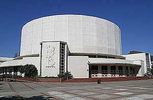
Berkeley Community Theater
Theater in Berkeley, California, U.S.
Distance: Approx. 662 meters
Latitude and longitude: 37.86845,-122.27147
Berkeley Community Theater is a theater located in Berkeley, California, United States, on the campus of Berkeley High School. The theater is administered by the Berkeley Unified School District. It is listed as a Berkeley Landmark (no.
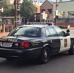
Berkeley Police Department
Police department serving Berkeley, California
Distance: Approx. 742 meters
Latitude and longitude: 37.869925,-122.272975
The Berkeley Police Department (BPD) is the municipal police department for the city of Berkeley, California, United States.
Congregation Beth Israel (Berkeley, California)
Distance: Approx. 315 meters
Latitude and longitude: 37.86609,-122.27791
Congregation Beth Israel (Hebrew: בית ישראל) is a Modern Orthodox synagogue in Berkeley, California, in the United States. Established in 1924 as the Berkeley Hebrew Center, it traces its origins to the First Hebrew Congregation of Berkeley, founded in 1909. It was Berkeley's first synagogue and remains its oldest.

United States Post Office (Berkeley, California)
United States historic post office
Distance: Approx. 766 meters
Latitude and longitude: 37.86888889,-122.27027778
The U.S. Post Office, also known as the Berkeley Main Post Office, is a local branch of the United States Postal Service. The building, located at 2000 Allston Way, Berkeley, California, was built in 1914–15. The building has been described as a "free adaptation of Brunelleschi's Foundling Hospital." Designed in the Second Renaissance Revival style, the front of the building features terra cotta arches supported by plain tuscan columns.
Berkeley balcony collapse
2015 accident in Berkeley, California, US
Distance: Approx. 754 meters
Latitude and longitude: 37.86819444,-122.26958333
On June 16, 2015, shortly after midnight, five Irish J-1 visa students and one Irish-American died and seven others were injured after a balcony on which they were standing collapsed. The group was celebrating a 21st birthday party in Berkeley, California. The balcony was on the 5th floor of an apartment building at 2020 Kittredge Street in Berkeley, then called Library Gardens.
Berkeley Buddhist Monastery
Chan Buddhist monastery in Berkeley, California
Distance: Approx. 370 meters
Latitude and longitude: 37.866551,-122.273831
The Berkeley Buddhist Monastery is a Chan Buddhist monastery in Berkeley, California affiliated with the City of Ten Thousand Buddhas and led by Heng Sure. It is the site of the Institute for World Religions, founded by Hsuan Hua. The Monastery opened in 1994.
The Rainbow Sign
African-American cultural center in Berkeley
Distance: Approx. 556 meters
Latitude and longitude: 37.8599,-122.2719
The Rainbow Sign was an African-American cultural center in Berkeley, California, that operated from 1971 to 1977. Vice President of the United States Kamala Harris frequently attended the center as a child, and described it as influential on her. The Guardian stated that "Rainbow Sign was a little bit of everything to the black community....

Boone's University School
Historic building in Berkeley, California
Distance: Approx. 808 meters
Latitude and longitude: 37.86694444,-122.26777778
Boone's University School is a historic building at 2029 Durant Avenue in Berkeley, California, U.S. It is the last surviving building from the Boone's University School for Boys, which closed in 1915. It is listed on the National Register of Historic Places since November 1, 1982; listed as a California Historical Landmark since November 1, 1982; and listed as a Berkeley Landmark since March 16, 1981. Since 2000, the building has been home to the Persian Center, a cultural and heritage organization for the Iranian diaspora and Iranian Americans.

Berkeley High School Campus Historic District
Historic district in California, US
Distance: Approx. 625 meters
Latitude and longitude: 37.867694,-122.271
Berkeley High School Campus Historic District is a 12.5 acres (5.1 ha) historic district in Berkeley, California, U.S. It is situated on four consolidated city blocks, bordered by Martin Luther King Jr. Way, Allston Way, Milvia Street, and Channing Way; and contains the Berkeley High School campus. It has been listed on the National Register of Historic Places since January 7, 2008; and listed on the California Historical Landmark since January 7, 2008.

Old Berkeley City Hall
Historic building in Berkeley, California
Distance: Approx. 646 meters
Latitude and longitude: 37.8691,-122.2733
Old Berkeley City Hall, also known as the Maudelle Shirek Building, is a historic building in the Civic Center neighborhood of Berkeley, California, U.S.. It was originally located at 2134 Grove Street (now 2134 Martin Luther King Jr. Way).

Corder Building
Historic building in Berkeley, California
Distance: Approx. 794 meters
Latitude and longitude: 37.867092,-122.268047
Corder Building, is a historical English Cottage building in downtown Berkeley, California. The Corder brick building was built in 1900. The building was listed on the National Register of Historic Places on January 11, 1982.
Weather in this IP's area
light rain
16 Celsius
15 Celsius
14 Celsius
17 Celsius
1021 hPa
65 %
1021 hPa
1017 hPa
10000 meters
3.6 m/s
300 degree
75 %
06:47:02
16:59:49