Country:
Region:
City:
Latitude and Longitude:
Time Zone:
Postal Code:
IP information under different IP Channel
ip-api
Country
Region
City
ASN
Time Zone
ISP
Blacklist
Proxy
Latitude
Longitude
Postal
Route
Luminati
Country
Region
wv
City
pineville
ASN
Time Zone
America/New_York
ISP
SHENTEL
Latitude
Longitude
Postal
IPinfo
Country
Region
City
ASN
Time Zone
ISP
Blacklist
Proxy
Latitude
Longitude
Postal
Route
db-ip
Country
Region
City
ASN
Time Zone
ISP
Blacklist
Proxy
Latitude
Longitude
Postal
Route
ipdata
Country
Region
City
ASN
Time Zone
ISP
Blacklist
Proxy
Latitude
Longitude
Postal
Route
Popular places and events near this IP address

Wyoming County, West Virginia
County in West Virginia, United States
Distance: Approx. 3112 meters
Latitude and longitude: 37.61,-81.54
Wyoming County is a county in the U.S. state of West Virginia. As of the 2020 census, the population was 21,382. Its county seat is Pineville.

Pineville, West Virginia
Town in West Virginia, United States
Distance: Approx. 239 meters
Latitude and longitude: 37.58305556,-81.53527778
Pineville is a town in and the county seat of Wyoming County, West Virginia, United States, situated along the Guyandotte River. The population was 648 at the 2020 census.
Windom, West Virginia
Unincorporated community in West Virginia, United States
Distance: Approx. 3411 meters
Latitude and longitude: 37.59861111,-81.57027778
Windom is an unincorporated community in Wyoming County, West Virginia, United States. Windom was originally known as Darby until November 1899. It was named for former United States Secretary of the Treasury, William Windom.

New Richmond, West Virginia
Census-designated place in West Virginia, United States
Distance: Approx. 4512 meters
Latitude and longitude: 37.57,-81.48888889
New Richmond is a census-designated place (CDP) in Wyoming County, West Virginia, United States. As of the 2010 census, its population was 238. The community is the site of Wyoming East High School.
Castle Rock (Pineville, West Virginia)
Distance: Approx. 101 meters
Latitude and longitude: 37.5825,-81.53872222
Castle Rock is a geological feature located in Pineville, West Virginia, USA. Castle Rock stands next to the Pineville Public Library. Named for its resemblance to a castle, it rises about 200 feet above Rockcastle Creek, a branch of the Guyandotte River. Its base is estimated to be 100 feet in diameter.

Wyoming County Courthouse and Jail
United States historic place
Distance: Approx. 168 meters
Latitude and longitude: 37.58361111,-81.53777778
The Wyoming County Courthouse and Jail is a historic courthouse and jail located in Pineville, Wyoming County, West Virginia. It consists of the unusually large neoclassical courthouse, with a massive pediment, and an adjoining stone jail. The courthouse was designed by West Virginia state architect A. F. Wysong and built in 1916 of locally quarried stone.
Glover, West Virginia
Unincorporated community in West Virginia, United States
Distance: Approx. 4642 meters
Latitude and longitude: 37.58666667,-81.59
Glover is an unincorporated community and coal town in Wyoming County, West Virginia, United States.
Mullensville, West Virginia
Unincorporated community in West Virginia, United States
Distance: Approx. 1938 meters
Latitude and longitude: 37.5775,-81.55888889
Mullensville is an unincorporated community in Wyoming County, West Virginia, United States.
Rock View, West Virginia
Unincorporated community in West Virginia, United States
Distance: Approx. 3974 meters
Latitude and longitude: 37.61777778,-81.53916667
Rock View is an unincorporated community in Wyoming County, West Virginia, United States. The community takes its name from a nearby rock formation, Castle Rock.
Wyoming, West Virginia
Unincorporated community in West Virginia, United States
Distance: Approx. 5717 meters
Latitude and longitude: 37.58222222,-81.6025
Wyoming is an unincorporated community in Wyoming County, West Virginia, United States. It gets its name from the counties name. Wyoming sits along the Guyandotte River.

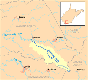
Pinnacle Creek
River in West Virginia, United States
Distance: Approx. 813 meters
Latitude and longitude: 37.5748351,-81.5367722
Pinnacle Creek is a tributary of the Guyandotte River, 26.6 miles (42.8 km) long, in southern West Virginia in the United States. Via the Guyandotte and Ohio rivers, it is part of the watershed of the Mississippi River, draining an area of 57.23 square miles (148.2 km2) in a rural area on the unglaciated portion of the Allegheny Plateau. Pinnacle Creek's entire course and drainage area are in southern Wyoming County.
Rockcastle Creek
River in the United States of America
Distance: Approx. 58 meters
Latitude and longitude: 37.58222222,-81.53833333
Rockcastle Creek is a stream in the U.S. state of West Virginia. Rockcastle Creek takes its name from a nearby rock formation, Castle Rock.
Weather in this IP's area
overcast clouds
13 Celsius
12 Celsius
11 Celsius
15 Celsius
1024 hPa
62 %
1024 hPa
972 hPa
10000 meters
2.5 m/s
6.37 m/s
118 degree
100 %
07:00:09
17:19:59