184.164.31.240 - IP Lookup: Free IP Address Lookup, Postal Code Lookup, IP Location Lookup, IP ASN, Public IP
Country:
 USA
USARegion:
City:
Location:
Time Zone:
Postal Code:
ISP:
ASN:
language:
User-Agent:
Proxy IP:
Blacklist:
IP information under different IP Channel
ip-api
Country
Region
City
ASN
Time Zone
ISP
Blacklist
Proxy
Latitude
Longitude
Postal
Route
db-ip
Country
Region
City
ASN
Time Zone
ISP
Blacklist
Proxy
Latitude
Longitude
Postal
Route
IPinfo
Country
Region
City
ASN
Time Zone
ISP
Blacklist
Proxy
Latitude
Longitude
Postal
Route
IP2Location
184.164.31.240Country
usRegion
illinois
City
freeport
Time Zone
America/Chicago
ISP
Language
User-Agent
Latitude
Longitude
Postal
ipdata
Country
Region
City
ASN
Time Zone
ISP
Blacklist
Proxy
Latitude
Longitude
Postal
Route
Popular places and events near this IP address

Freeport, Illinois
City in Illinois, United States
Distance: Approx. 916 meters
Latitude and longitude: 42.29194444,-89.63027778
Freeport is the county seat and largest city of Stephenson County, Illinois, United States. The population was 23,973 at the 2020 census, and the mayor of Freeport is Jodi Miller, elected in 2017. Freeport is known for hosting the second Lincoln–Douglas debate of 1858, and as "Pretzel City, USA", due to a popular local German bakery that became well known for its prolific pretzel production after it opened in 1869.

Freeport Township, Illinois
Township in Illinois, United States
Distance: Approx. 1323 meters
Latitude and longitude: 42.29027778,-89.63472222
Freeport Township is located in Stephenson County, Illinois. As of the 2010 census, its population was 25,638 and it contained 12,396 housing units. Freeport Township is coterminous with City of Freeport.

Winneshiek Players
Distance: Approx. 420 meters
Latitude and longitude: 42.2995,-89.62461111
The Winneshiek Players is an amateur theater group in Freeport, Illinois. It was founded in 1916 and has offered a season of performances for every year since 1926. The Winneshiek Players claims to be the oldest continuously operating volunteer (amateur) theater group in the United States.

Aquin Catholic Schools
Private school in Freeport, Illinois, United States
Distance: Approx. 1734 meters
Latitude and longitude: 42.28583333,-89.60611111
Aquin Catholic Schools is a group of three private Catholic schools in Freeport, Illinois, United States, in the Roman Catholic Diocese of Rockford.
Yellow Creek (Illinois)
River in Illinois, United States
Distance: Approx. 4322 meters
Latitude and longitude: 42.29,-89.5695
Yellow Creek is a tributary of the Pecatonica River in Stephenson County, in the US state of Illinois. The 50-mile (80 km) stream also flows through a small part of Jo Daviess County. The waters of Yellow Creek were assessed for water quality in 1996, with 28 miles (45 km) being listed as "fair" and 22 miles (35 km) being listed as "good".

Oscar Taylor House
Historic house in Illinois, United States
Distance: Approx. 1482 meters
Latitude and longitude: 42.28444444,-89.61416667
The Oscar Taylor House is a historic house in the city of Freeport, Illinois. The house was built in 1857 and served as a "station" on the Underground Railroad during the American Civil War. It was added to the National Register of Historic Places in 1984.
WFRL
Radio station in Illinois, United States
Distance: Approx. 2813 meters
Latitude and longitude: 42.31251944,-89.59456111
WFRL (1570 AM) is a radio station licensed to Freeport, Illinois. WFRL airs a classic country format and is owned by Big Radio. Its studios and transmitter are at 834 North Tower Road, northeast of Freeport.

Freeport station (Illinois)
Rail station in Freeport, Illinois, US
Distance: Approx. 603 meters
Latitude and longitude: 42.2997,-89.6151
Freeport station is a former train station in Freeport, Illinois. It was in use from 1849 to 1971 and 1974 to 1981.

Soldiers' Monument (Freeport, Illinois)
United States historic place
Distance: Approx. 135 meters
Latitude and longitude: 42.29777778,-89.62194444
The Soldiers' Monument is an American Civil War memorial located at the northern corner of Galena Avenue and Stephenson Street in Freeport, Illinois. General Smith D. Atkins designed the monument, which was erected in 1871. The limestone obelisk monument is 83 feet (25 m) tall; a statue of Victory originally topped the monument, but it was destroyed by a lightning strike in 1960.
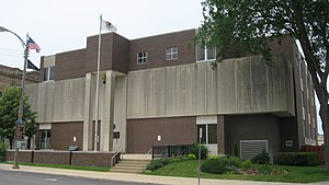
Stephenson County Courthouse
Local government building in the United States
Distance: Approx. 163 meters
Latitude and longitude: 42.29805556,-89.62194444
The Stephenson County Courthouse, located on Courthouse Square in Freeport, is the county courthouse serving Stephenson County, Illinois. The present courthouse was built in 1975, replacing a historic courthouse built on the site in 1870. Elijah E. Myers, who went on to design three state capitols, designed the 1870 courthouse in the Second Empire style; the building, which featured a mansard roof and a projecting entrance pavilion, was Myers' only Second Empire work.

Freeport City Hall
United States historic place
Distance: Approx. 197 meters
Latitude and longitude: 42.2975,-89.62333333
The Freeport City Hall, located at 230 West Stephenson Street, was the historic city hall of Freeport, Illinois.
Willow Lake, Illinois
Census-designated place in Illinois, United States
Distance: Approx. 4203 meters
Latitude and longitude: 42.33305556,-89.635
Willow Lake is a census-designated place (CDP) surrounding a lake of the same name in Stephenson County, Illinois, United States. It is in the center of the county, on the north side of U.S. Route 20 and 3 miles (5 km) north of the center of Freeport, the county seat. Willow Lake was first listed as a CDP prior to the 2020 census.
Weather in this IP's area
overcast clouds
-1 Celsius
-7 Celsius
-2 Celsius
-1 Celsius
1018 hPa
69 %
1018 hPa
985 hPa
10000 meters
6.69 m/s
8.23 m/s
100 degree
100 %