184.164.232.215 - IP Lookup: Free IP Address Lookup, Postal Code Lookup, IP Location Lookup, IP ASN, Public IP
Country:
Region:
City:
Location:
Time Zone:
Postal Code:
IP information under different IP Channel
ip-api
Country
Region
City
ASN
Time Zone
ISP
Blacklist
Proxy
Latitude
Longitude
Postal
Route
Luminati
Country
ASN
Time Zone
America/Chicago
ISP
PEERING-RESEARCH-TESTBED-USC-UFMG-AS47065
Latitude
Longitude
Postal
IPinfo
Country
Region
City
ASN
Time Zone
ISP
Blacklist
Proxy
Latitude
Longitude
Postal
Route
IP2Location
184.164.232.215Country
Region
new york
City
new york city
Time Zone
America/New_York
ISP
Language
User-Agent
Latitude
Longitude
Postal
db-ip
Country
Region
City
ASN
Time Zone
ISP
Blacklist
Proxy
Latitude
Longitude
Postal
Route
ipdata
Country
Region
City
ASN
Time Zone
ISP
Blacklist
Proxy
Latitude
Longitude
Postal
Route
Popular places and events near this IP address

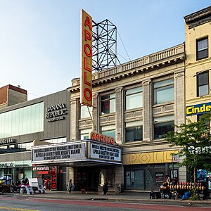
Apollo Theater
Entertainment venue in Manhattan, New York
Distance: Approx. 324 meters
Latitude and longitude: 40.81,-73.95
The Apollo Theater (formerly the Hurtig & Seamon's New Theatre; also Apollo Theatre or 125th Street Apollo Theatre) is a multi-use theater at 253 West 125th Street in the Harlem neighborhood of Upper Manhattan in New York City. It is a popular venue for black American performers and is the home of the TV show Showtime at the Apollo. The theater, which has approximately 1,500 seats across three levels, was designed by George Keister with elements of the neoclassical style.
125th Street (Manhattan)
West-east street in Manhattan, New York
Distance: Approx. 98 meters
Latitude and longitude: 40.8108,-73.9526
125th Street, co-named Martin Luther King Jr., Boulevard is a two-way street that runs east–west in the New York City borough of Manhattan, from First Avenue on the east to Marginal Street, a service road for the Henry Hudson Parkway along the Hudson River in the west. It is often considered to be the "Main Street" of Harlem. Notable buildings along 125th Street include the Apollo Theater, the Adam Clayton Powell Jr.

125th Street station (IND Eighth Avenue Line)
New York City Subway station in Manhattan
Distance: Approx. 99 meters
Latitude and longitude: 40.810756,-73.952665
The 125th Street station is an express station on the IND Eighth Avenue Line of the New York City Subway. Located at the intersection of 125th Street and St. Nicholas Avenue in the Harlem neighborhood of Manhattan, it is served by the A and D trains at all times, by the C train at all times except late nights, and by the B train on weekdays.
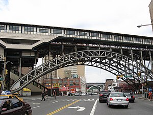
125th Street station (IRT Ninth Avenue Line)
Former Manhattan Railway elevated station (closed 1940)
Distance: Approx. 229 meters
Latitude and longitude: 40.81027778,-73.95111111
The 125th Street station was an express station on the demolished IRT Ninth Avenue Line in Manhattan, New York City. It had three tracks and two island platforms. It opened on September 17, 1879, and closed on June 11, 1940.

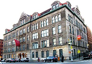
P.S. 157
United States historic place
Distance: Approx. 70 meters
Latitude and longitude: 40.81166667,-73.9525
P.S. 157 is a historic school building located at 327 St. Nicholas Avenue between West 126th and West 127th Streets in the Harlem neighborhood of Manhattan, New York City. It was built from 1896 to 1899 and was designed by C. B. J. Snyder in the Renaissance Revival style.

Columbia Secondary School
Public school in New York City
Distance: Approx. 238 meters
Latitude and longitude: 40.81055556,-73.95583333
The Columbia Secondary School for Math, Science, & Engineering (also known as CSS) is a selective public, sixth- through twelfth-grade school that opened in 2007. A partnership between the New York City Department of Education, the community, and Columbia University, CSS serves students who have an interest in a program focusing on STEM fields. Columbia Secondary School has been cited as one of the most desirable schools in New York City.
Sydenham Hospital
Former hospital in New York City
Distance: Approx. 184 meters
Latitude and longitude: 40.80986111,-73.95361111
Sydenham Hospital was a healthcare facility in Harlem, Manhattan, New York, which operated between 1892 and 1980. It was located at 124th Street and Manhattan Avenue.

St. Joseph of the Holy Family Church (New York City)
Church in Manhattan, New York
Distance: Approx. 75 meters
Latitude and longitude: 40.81166667,-73.95416667
The Church of St. Joseph of the Holy Family is a Black Catholic parish in the Archdiocese of New York, located at 401 West 125th Street at Morningside Avenue in the Harlem neighborhood of Manhattan, New York City. It is the oldest existing church in Harlem and above 44th Street in Manhattan.

West End Theatre (Manhattan)
Distance: Approx. 87 meters
Latitude and longitude: 40.81073,-73.95346
Two theatres in Harlem, New York City, have been named West End Theatre. The first, of 1899, was abandoned after the foundation was built. It was on the northeast corner of 124th Street and Seventh Avenue, which is today known as Adam Clayton Powell Jr.
Braddock Hotel
Hotel in Manhattan, New York
Distance: Approx. 246 meters
Latitude and longitude: 40.81086,-73.95051
Braddock Hotel was a hotel at the corner of 126th Street and 8th Avenue in New York City, near the Apollo Theater. The hotel bar was popular with black jazz musicians, and Dizzy Gillespie, Billy Eckstine, Billie Holiday, Ella Fitzgerald and Dinah Washington performed here. Before he joined the Nation of Islam, Malcolm X (then known as Malcolm Little) often spent time at the hotel's bar.
Faison Firehouse Theater
Distance: Approx. 148 meters
Latitude and longitude: 40.81022222,-73.95377778
The Faison Firehouse Theater is a theater in Harlem, New York founded in 1999 by Tony award winning choreographer George Faison and Tad Schnugg. It is operated by the American Performing Arts Collaborative (APAC), a not-for-profit (501c3) founded in 1997.
Freddy's Fashion Mart attack
1995 criminal attack in Harlem, New York City
Distance: Approx. 291 meters
Latitude and longitude: 40.80969,-73.9508
On December 8, 1995, eight people, including the assailant, were killed when a gunman seized hostages at Freddy's Fashion Mart in Harlem, New York City, and set the building on fire.
Weather in this IP's area
clear sky
-3 Celsius
-8 Celsius
-6 Celsius
-1 Celsius
1032 hPa
73 %
1032 hPa
1030 hPa
10000 meters
3.58 m/s
4.92 m/s
94 degree

