184.14.174.240 - IP Lookup: Free IP Address Lookup, Postal Code Lookup, IP Location Lookup, IP ASN, Public IP
Country:
 USA
USARegion:
City:
Location:
Time Zone:
Postal Code:
ISP:
ASN:
language:
User-Agent:
Proxy IP:
Blacklist:
IP information under different IP Channel
ip-api
Country
Region
City
ASN
Time Zone
ISP
Blacklist
Proxy
Latitude
Longitude
Postal
Route
db-ip
Country
Region
City
ASN
Time Zone
ISP
Blacklist
Proxy
Latitude
Longitude
Postal
Route
IPinfo
Country
Region
City
ASN
Time Zone
ISP
Blacklist
Proxy
Latitude
Longitude
Postal
Route
IP2Location
184.14.174.240Country
usRegion
west virginia
City
charleston
Time Zone
America/New_York
ISP
Language
User-Agent
Latitude
Longitude
Postal
ipdata
Country
Region
City
ASN
Time Zone
ISP
Blacklist
Proxy
Latitude
Longitude
Postal
Route
Popular places and events near this IP address
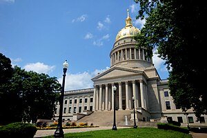
Charleston, West Virginia
Capital and most populous city of West Virginia, US
Distance: Approx. 11 meters
Latitude and longitude: 38.34981944,-81.63262222
Charleston is the capital and most populous city of the U.S. state of West Virginia. It is the seat of Kanawha County and is located at the confluence of the Elk and Kanawha rivers. The population was 48,864 at the 2020 census.

Mattie V. Lee Home
Historic house in West Virginia, United States
Distance: Approx. 254 meters
Latitude and longitude: 38.35166667,-81.63083333
Mattie V. Lee Home is a historic home located at Charleston, West Virginia. It stands on what was once a densely packed commercial block close to the center of a historically African-American neighborhood in Charleston. It was built about 1920 and is a two-story concrete block structure with a prominent raised basement and features a two-tier front porch.

Samuel Starks House
Historic house in West Virginia, United States
Distance: Approx. 189 meters
Latitude and longitude: 38.35055556,-81.63055556
Samuel Starks House is a historic home located at Charleston, West Virginia. It is an American Foursquare style home built in 1908, as home for Samuel W. Starks (1866–1908). Starks was a nationally prominent African American leader in the Knights of Pythias fraternal organization.

Daniel Boone Hotel (Charleston, West Virginia)
United States historic place
Distance: Approx. 179 meters
Latitude and longitude: 38.35138889,-81.63222222
Daniel Boone Hotel is a historic hotel located at Charleston, West Virginia. It is a Classical Revival Style ten story structure with blond brick exterior and tan, modular, stone-looking terra cotta. The building was originally constructed in 1927–1929, expanded in 1936 and again in 1949 to provide a total of 465 rooms, a large ballroom and 3 parlor meeting rooms.

Kearse Theater
United States historic place
Distance: Approx. 283 meters
Latitude and longitude: 38.35111111,-81.63527778
Kearse Theater was a historic theatre building located at Charleston, West Virginia. It was constructed in 1921 and composed of a single floor auditorium with balcony behind a three-story front section which included two storefronts. It was designed for stage shows as well as for movies.

Loewenstein and Sons Hardware Building
United States historic place
Distance: Approx. 211 meters
Latitude and longitude: 38.35055556,-81.63472222
Loewenstein and Sons Hardware Building, also known as the Loewenstein Building or Rite Aid Building, is a historic commercial structure located at Charleston, West Virginia. It was designed by the Columbus, Ohio architectural firm of Yost & Packard. The building is 35,000 square feet (3,300 m2) in a five-story pressed brick structure that features eclectic late Victorian and classical details.

Sterrett Brothers' Dry Goods Store
United States historic place
Distance: Approx. 270 meters
Latitude and longitude: 38.34944444,-81.63555556
Sterrett Brothers' Dry Goods Store is a historic commercial structure located at Charleston, West Virginia. It was built about 1890 in what has become known as the "Victorian Block" of Charleston. The building originally had three floors with a storefront on the first floor.

Plaza Theatre (Charleston, West Virginia)
United States historic place
Distance: Approx. 268 meters
Latitude and longitude: 38.35,-81.63555556
Plaza Theatre, also known as the Capitol Theater or West Virginia State University Capitol Center, is a historic theatre building located at Charleston, West Virginia. It was constructed about 1912 and is a turn-of-the-century theater/commercial/office building located in a transitional business district of downtown Charleston. The three-story brick structure is characterized by eclectic Classical Revival style architecture incorporating a number of elements from classical Greek forms.

Garnet High School
United States historic place
Distance: Approx. 263 meters
Latitude and longitude: 38.35111111,-81.63
Garnet High School, also known as Garnet Career Center and Garnet Adult Education Center, is a historic African-American high school in Charleston, West Virginia. The school was established when "twelve African-American students in Kanawha County passed an entrance examination for high school level course work." It was named after Henry Highland Garnet, a former slave who became the United States' ambassador to Liberia. It is a three-story, brick structure, constructed in 1928-29 from the plans of the prestigious Charleston architectural firm of Warne, Tucker, Silling and Hutchison, and dedicated December 2 to 4, 1929.
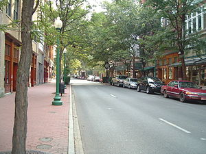
Downtown Charleston Historic District
Historic district in West Virginia, United States
Distance: Approx. 168 meters
Latitude and longitude: 38.35055556,-81.63416667
Downtown Charleston Historic District is a national historic district located at Charleston, West Virginia, USA. The district contains contributing structures in the Late Victorian and Late 19th and 20th Century Revivals architectural styles. St. John's Episcopal Church (1884), the Basilica of the Co-Cathedral of the Sacred Heart (1897), and Woodrums' Building (1916) are contributing properties.

Basilica of the Co-Cathedral of the Sacred Heart
Historic church in West Virginia, United States
Distance: Approx. 277 meters
Latitude and longitude: 38.347325,-81.63285
The Basilica of the Co-Cathedral of the Sacred Heart is a cathedral church and a minor basilica located in Charleston, West Virginia, United States. Along with the Cathedral of St. Joseph in Wheeling it is the seat of the Catholic Diocese of Wheeling-Charleston.

Taylor Books
Independent Bookstore in Charleston, West Virginia, US
Distance: Approx. 137 meters
Latitude and longitude: 38.350986,-81.6329345
Taylor Books is an independent bookstore in Charleston, West Virginia. It specializes in Appalachian culture. It is credited with revitalizing downtown Charleston.
Weather in this IP's area
light snow
-0 Celsius
-3 Celsius
-1 Celsius
0 Celsius
1028 hPa
81 %
1028 hPa
992 hPa
10000 meters
2.06 m/s
20 degree
100 %