Country:
Region:
City:
Latitude and Longitude:
Time Zone:
Postal Code:
IP information under different IP Channel
ip-api
Country
Region
City
ASN
Time Zone
ISP
Blacklist
Proxy
Latitude
Longitude
Postal
Route
Luminati
Country
ASN
Time Zone
Asia/Tokyo
ISP
SAKURA Internet Inc.
Latitude
Longitude
Postal
IPinfo
Country
Region
City
ASN
Time Zone
ISP
Blacklist
Proxy
Latitude
Longitude
Postal
Route
db-ip
Country
Region
City
ASN
Time Zone
ISP
Blacklist
Proxy
Latitude
Longitude
Postal
Route
ipdata
Country
Region
City
ASN
Time Zone
ISP
Blacklist
Proxy
Latitude
Longitude
Postal
Route
Popular places and events near this IP address
Ōsaka Station
Major railway and metro station in Osaka, Japan
Distance: Approx. 282 meters
Latitude and longitude: 34.7025,135.49611111
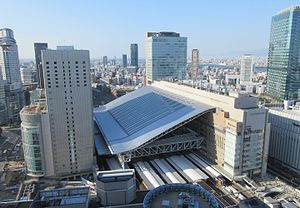
Ōsaka Station (大阪駅, Ōsaka-eki) is a major railway station in the Umeda district of Kita-ku, Osaka, Japan, operated by West Japan Railway Company (JR West). It forms as one of the city's main railway terminals to the north, the other being Shin-Ōsaka. Although it is officially served by only the JR Kobe/Kyoto Lines (Tōkaidō Main Line) and the Osaka Loop Line, Ōsaka is the starting point of JR Takarazuka Line service, and serves as the terminal for trains bound for the San'in region via JR Takarazuka Line and the Hokuriku region via JR Kyoto Line, while offering connections to trains bound for Nara, Wakayama and Kansai International Airport via the Osaka Loop Line.

Umeda
Business District in Osaka Prefecture, Japan
Distance: Approx. 107 meters
Latitude and longitude: 34.7,135.497
Umeda (Japanese: 梅田) is a major commercial, business, shopping and entertainment district in Kita-ku, Osaka, Japan, and the city's main northern railway terminus (Ōsaka Station, Umeda Station). The district's name means "plum field".
HEP (shopping mall)
Shopping mall
Distance: Approx. 450 meters
Latitude and longitude: 34.7040028,135.5004466
HEP is a major shopping mall and entertainment center in the Umeda commercial district of Kita-ku, Osaka, Japan. It is a shopping mall consisting of a HEP Five and HEP Navio. HEP stands for "Hankyu Entertainment Park".

Nishi-Umeda Station
Metro station in Osaka, Japan
Distance: Approx. 236 meters
Latitude and longitude: 34.69960556,135.49566667
Nishi-Umeda Station (西梅田駅, Nishi-Umeda-eki, Y11) is the terminus railway station of the Osaka Metro Yotsubashi Line in Umeda, Kita-ku, Osaka, Japan, close to Herbis OSAKA and Herbis ENT operated by Hanshin Electric Railway Co., Ltd. and the two Hilton Plazas.
Higashi-Umeda Station
Metro station in Osaka, Japan
Distance: Approx. 152 meters
Latitude and longitude: 34.70097778,135.49955556
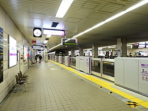
Higashi-Umeda Station (東梅田駅, Higashi-Umeda-eki, T20) is a railway station on the Osaka Metro Tanimachi Line in Umeda, Kita-ku, Osaka, Japan. The station is located along Whity Umeda.

Dōyamachō
District in Osaka, Japan
Distance: Approx. 522 meters
Latitude and longitude: 34.70305556,135.50277778
Dōyamachō (Japanese: 堂山町) is a district in the Umeda area of Osaka, Japan. It is close to the JR Osaka and Umeda Station, many restaurants, bars, izakaya, karaoke, massage parlors, host clubs, hotels, and shops concentrate in the area. Many salarymen, OL (office ladies) and students stop by Dōyamachō to have fun in the evening before they go back home.

Dōjima Rice Exchange
Center of Japan's rice brokers during the Edo period located in Osaka, Japan
Distance: Approx. 593 meters
Latitude and longitude: 34.6952,135.49867
The Dōjima Rice Exchange (堂島米市場, Dōjima kome ichiba, 堂島米会所, Dōjima kome kaisho), located in Osaka, was the center of Japan's system of rice brokers, which developed independently and privately in the Edo period and would be seen as the forerunners to a modern banking system. It was first established in 1697, officially sanctioned, sponsored and organized by the shogunate in 1773, reorganized in 1868, and dissolved entirely in 1939, being absorbed into the Government Rice Agency (日本米穀株式会社)(cf.ja:食糧管理制度). The Japanese economy grew rapidly throughout the 17th century, culminating in the period known as Genroku (1688–1704) during which merchants prospered like never before.
Kitashinchi Station
Railway station in Osaka, Japan
Distance: Approx. 258 meters
Latitude and longitude: 34.69832222,135.49703611
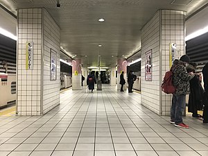
Kitashinchi Station (北新地駅, Kitashinchi-eki) is a railway station on the West Japan Railway (JR West) JR Tōzai Line in Kita-ku, Osaka, Japan. The station is located in the Kitashinchi dining and entertainment district of Osaka, and at 23.95 metres (78.6 ft) below sea level, it is the deepest station in the JR West system. Although officially separated from Osaka Station, the main terminal, passengers can transfer for free from the JR Kobe Line or the Osaka Loop Line at Osaka to the Tōzai Line at Kitashinchi, and vice versa, with some tickets and passes.

Ōebashi Station
Railway station in Osaka, Japan
Distance: Approx. 707 meters
Latitude and longitude: 34.694357,135.499964
Ōebashi Station (大江橋駅, Ōebashi-eki) is a railway station on the Keihan Electric Railway Nakanoshima Line in Kita-ku, Osaka, Japan, and opened on October 19, 2008 (the day of the opening of the Nakanoshima Line).
Taiyū-ji
Distance: Approx. 577 meters
Latitude and longitude: 34.7018,135.5041
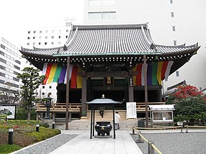
Taiyū-ji (太融寺) is a Buddhist temple in Osaka Prefecture, Japan. It was founded in 821.
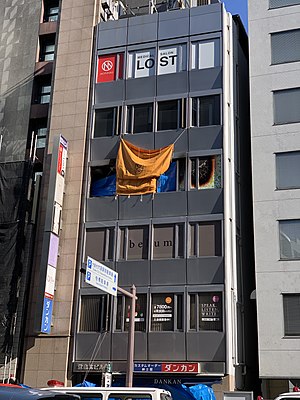
2021 Osaka building fire
Suspected arson attack in Osaka, Japan
Distance: Approx. 376 meters
Latitude and longitude: 34.6977,135.4957
On 17 December 2021, a fire occurred in a psychiatric clinic located on the fourth floor of the Dojima Kita Building in Kita-ku, Osaka, Japan. The fire is suspected to have been started deliberately. 26 people were killed and a 27th was injured.

Consulate General of the United States, Osaka
Diplomatic mission
Distance: Approx. 543 meters
Latitude and longitude: 34.69683333,135.50191667
The Consulate-General of the United States in Osaka-Kobe (Japanese: 駐大阪・神戸米国総領事館), commonly referred to as the U.S. Consulate-General in Osaka, is a consular post of the United States in Osaka City, Osaka Prefecture, Japan. The inclusion of "Kobe" in the name stems from its previous location in Kobe City, Hyogo Prefecture. The consulate has a public relations division known as the Kansai American Center.
Weather in this IP's area
light rain
18 Celsius
18 Celsius
18 Celsius
18 Celsius
1017 hPa
82 %
1017 hPa
1015 hPa
8000 meters
3.09 m/s
40 degree
75 %
06:32:53
16:52:54
