Country:
 Hong Kong (China)
Region:
City:
Latitude and Longitude:
Time Zone:
Postal Code:
IP information under different IP Channel
ip-api
Country
Region
City
ASN
Time Zone
ISP
Blacklist
Proxy
Latitude
Longitude
Postal
Route
IPinfo
Country
Region
City
ASN
Time Zone
ISP
Blacklist
Proxy
Latitude
Longitude
Postal
Route
MaxMind
Country
Region
City
ASN
Time Zone
ISP
Blacklist
Proxy
Latitude
Longitude
Postal
Route
Luminati
Country
HKASN
Time Zone
Asia/Hong_Kong
ISP
YAHOO-1
Latitude
Longitude
Postal
db-ip
Country
Region
City
ASN
Time Zone
ISP
Blacklist
Proxy
Latitude
Longitude
Postal
Route
ipdata
Country
Region
City
ASN
Time Zone
ISP
Blacklist
Proxy
Latitude
Longitude
Postal
Route
Popular places and events near this IP address

Sai Ying Pun station
MTR station on Hong Kong Island
Distance: Approx. 123 meters
Latitude and longitude: 22.2856,114.1427
Sai Ying Pun is a station on the MTR network. The station is located between HKU and Sheung Wan on the Island line. It serves the neighbourhood of Sai Ying Pun and the western part of Mid-Levels in northwestern Hong Kong Island, Hong Kong.

West Point, Hong Kong
Distance: Approx. 168 meters
Latitude and longitude: 22.28698611,114.14045833
West Point (Chinese: 西點 or 西角) was a point of land on Hong Kong Island, Hong Kong, south of Sulphur Channel. Its location is the shore off Pok Fu Lam Road and Queen's Road West in 1845, approximately the junction of Western Street and Des Voeux Road West near Western Police Station. This was the northernmost point on the western half of Hong Kong Island.

Sai Ying Pun
Area of Western District, Hong Kong
Distance: Approx. 108 meters
Latitude and longitude: 22.28591,114.14283
Sai Ying Pun is an area in Sai Wan, on Hong Kong Island, in Hong Kong. It is administratively part of the Central and Western District.

Bonham Road
Main road in Mid-Levels West, Hong Kong
Distance: Approx. 259 meters
Latitude and longitude: 22.2842,114.1424
Bonham Road is a main road in West Mid-Levels, Hong Kong Island in Hong Kong, running mainly East-West. The road connects Pok Fu Lam Road in the west, near the University of Hong Kong, and Caine Road in the east, at the junction with Hospital Road and Seymour Road. It was named after Sir George Bonham, the third Governor of Hong Kong.

Eastern Street (Hong Kong)
Distance: Approx. 244 meters
Latitude and longitude: 22.28487,114.14358
Eastern Street is an early street of Hong Kong, located in the Sai Ying Pun area of Hong Kong Island. Eastern Street North (東邊街北) is an extension of the street leading to the seafront following progressive harbour reclamations.
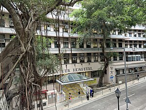
Tsan Yuk Hospital
Hospital in Sai Ying Pun, Hong Kong
Distance: Approx. 264 meters
Latitude and longitude: 22.286212,114.144541
Tsan Yuk Hospital is maternity hospital is located on 30 Hospital Road, Sai Ying Pun on Hong Kong Island, is a public hospital in Hong Kong, It was specialising in obstetrics and gynaecology. It also operates as a teaching and training hospital for the medical and nursing students of Li Ka Shing Faculty of Medicine of the University of Hong Kong. Tsan Yuk Hospital was located at No.

Western Street (Hong Kong)
Distance: Approx. 170 meters
Latitude and longitude: 22.28548,114.14077
Western Street is an uphill one-way street (from north to south) in Sai Ying Pun, Hong Kong. It connects Bonham Road in the south and Connaught Road West in the north. There are 337 units in 17 buildings in the street.

Centre Street (Hong Kong)
Street in Sai Ying Pun, Hong Kong
Distance: Approx. 34 meters
Latitude and longitude: 22.2863,114.14225
Centre Street is a street in the Sai Ying Pun area of Hong Kong. Centre Street is the central point of the most active traditional market in Western District of Hong Kong Island. The street is part of planned streets in the early development of the area.

Old Tsan Yuk Maternity Hospital
Former hospital in Hong Kong
Distance: Approx. 134 meters
Latitude and longitude: 22.28592,114.14086
The Old Tsan Yuk Maternity Hospital is located at No. 36A Western Street, Sai Ying Pun, Hong Kong. It was founded in 1922 under the Chinese Public Dispensary Committee.

Prince Philip Dental Hospital
Hospital in Sai Ying Pun, Hong Kong
Distance: Approx. 234 meters
Latitude and longitude: 22.286455,114.144274
The Prince Philip Dental Hospital (PPDH) is a dental teaching hospital in Sai Ying Pun, Hong Kong. It houses the Faculty of Dentistry of the University of Hong Kong and is governed by the Prince Philip Dental Hospital Ordinance.

Sai Ying Pun Market
Market in Hong Kong
Distance: Approx. 81 meters
Latitude and longitude: 22.285899,114.142442
Sai Ying Pun Market (Chinese: 西營盤街市) is an indoor market along Centre Street, between Second and Third Streets, in Central and Western District's Sai Ying Pun, in Hong Kong near Sai Ying Pun station.

Kau Yan Church
Church building in Sai Ying Pun, Hong Kong
Distance: Approx. 162 meters
Latitude and longitude: 22.285494,114.140864
Tsung Tsin Mission of Hong Kong Kau Yan Church is a church in Sai Ying Pun, Hong Kong. The building is located at Western Street, between Third and High Streets. The church was established by the Basel Mission and is now succeeded by the Tsung Tsin Mission of Hong Kong.
Weather in this IP's area
clear sky
27 Celsius
27 Celsius
25 Celsius
27 Celsius
1015 hPa
64 %
1015 hPa
1010 hPa
10000 meters
2.68 m/s
30 degree
1 %
06:16:58
18:04:41