183.171.121.104 - IP Lookup: Free IP Address Lookup, Postal Code Lookup, IP Location Lookup, IP ASN, Public IP
Country:
Region:
City:
Location:
Time Zone:
Postal Code:
ISP:
ASN:
language:
User-Agent:
Proxy IP:
Blacklist:
IP information under different IP Channel
ip-api
Country
Region
City
ASN
Time Zone
ISP
Blacklist
Proxy
Latitude
Longitude
Postal
Route
db-ip
Country
Region
City
ASN
Time Zone
ISP
Blacklist
Proxy
Latitude
Longitude
Postal
Route
IPinfo
Country
Region
City
ASN
Time Zone
ISP
Blacklist
Proxy
Latitude
Longitude
Postal
Route
IP2Location
183.171.121.104Country
Region
sabah
City
papar
Time Zone
Asia/Kuching
ISP
Language
User-Agent
Latitude
Longitude
Postal
ipdata
Country
Region
City
ASN
Time Zone
ISP
Blacklist
Proxy
Latitude
Longitude
Postal
Route
Popular places and events near this IP address

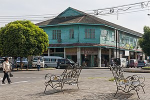
Papar, Malaysia
Town and district capital in Sabah, Malaysia
Distance: Approx. 5 meters
Latitude and longitude: 5.73333333,115.93333333
Papar (Malay: Pekan Papar) is the capital of the Papar District in the West Coast Division of Sabah, Malaysia. Its population was estimated to be around 124,420 in 2010, which is divided between Bruneian Malay (particularly in the villages of Benoni, Buang Sayang, Bongawan, Kampung Laut, Kelanahan, Takis, Kimanis and Kinarut), Kadazan-Dusun (concentrated in the villages of Rampazan, Limbahau, Kinarut, Kopimpinan, Lakut, Mondolipau, Kinuta, Bungug, Padawan, Koiduan, Ulu Kimanis, Sumbiling and Limputung), and Bajau (mostly in the villages of Pengalat Besar, Pengalat Kecil, Kawang, Kuala, Sg Padang and Beringgis). There is also a sizeable Chinese minority (including those of mixed-race or Sino-Native origin), predominantly of the Hakka subgroup, as well as smaller numbers of other races.
SMK Majakir Papar
Secondary school in Papar, Sabah, Malaysia
Distance: Approx. 780 meters
Latitude and longitude: 5.73194444,115.92638889
SMK Majakir Papar also known as Sekolah Menengah Kebangsaan Majakir Papar (SMKMP) in Malay, is a Malaysian secondary school in East Malaysia established in 1962.
SM St Joseph Papar
Malaysian secondary school
Distance: Approx. 433 meters
Latitude and longitude: 5.73083333,115.93027778
SMK St Joseph Papar is a Malaysian secondary school in Papar, Malaysia. It was established in 1953.
Takis National Secondary School
Secondary school in Sabah, Malaysia
Distance: Approx. 918 meters
Latitude and longitude: 5.72527778,115.93138889
Takis National Secondary School (Malay: Sekolah Menengah Kebangsaan Takis) is a national secondary school located in East Malaysia's Papar district. This school was established in 2001.

Papar railway station (Malaysia)
Railway station in Sabah, Malaysia
Distance: Approx. 127 meters
Latitude and longitude: 5.73265,115.93235278
Papar railway station (Malay: Stesen Keretapi Papar) is one of four main railway station on the Western Sabah Railway Line located in Papar, Sabah, Malaysia.

Papar District
District in Sabah, Malaysia
Distance: Approx. 5 meters
Latitude and longitude: 5.73333333,115.93333333
The Papar District (Malay: Daerah Papar) is an administrative district in the Malaysian state of Sabah, part of the West Coast Division which includes the districts of Kota Belud, Kota Kinabalu, Papar, Penampang, Putatan, Ranau and Tuaran. The capital of the district is in Papar Town.

Papar River
River in Sabah, Malaysia
Distance: Approx. 3490 meters
Latitude and longitude: 5.75238889,115.90830556
The Papar River (Malay: Sungai Papar) is a river in West Coast Division, northwestern Sabah of Malaysia. It has a total length of 60 km (37 miles) from its headwaters in the mountains of northwest Sabah to its outlet at the South China Sea, northwest of Papar town. It originates in the mountains in the interior Papar, Penampang and Tuaran Districts, which form part of the Crocker Range system.
Weather in this IP's area
overcast clouds
28 Celsius
33 Celsius
28 Celsius
28 Celsius
1012 hPa
90 %
1012 hPa
1009 hPa
10000 meters
0.8 m/s
0.77 m/s
302 degree
91 %
