Country:
 India
IndiaRegion:
City:
Latitude and Longitude:
Time Zone:
Postal Code:
IP information under different IP Channel
ip-api
Country
Region
City
ASN
Time Zone
ISP
Blacklist
Proxy
Latitude
Longitude
Postal
Route
IPinfo
Country
Region
City
ASN
Time Zone
ISP
Blacklist
Proxy
Latitude
Longitude
Postal
Route
MaxMind
Country
Region
City
ASN
Time Zone
ISP
Blacklist
Proxy
Latitude
Longitude
Postal
Route
Luminati
Country
INRegion
mh
City
mumbai
ASN
Time Zone
Asia/Kolkata
ISP
Mahanagar Telephone Nigam Limited
Latitude
Longitude
Postal
db-ip
Country
Region
City
ASN
Time Zone
ISP
Blacklist
Proxy
Latitude
Longitude
Postal
Route
ipdata
Country
Region
City
ASN
Time Zone
ISP
Blacklist
Proxy
Latitude
Longitude
Postal
Route
Popular places and events near this IP address

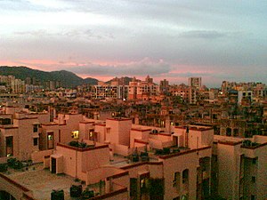
Kharghar
Nodal city of Navi Mumbai in Maharashtra, India
Distance: Approx. 1789 meters
Latitude and longitude: 19.036146,73.0617213
Kharghar is a node of Raigad District's Navi Mumbai and it is a suburb under Panvel Municipal Corporation. It is situated at the northernmost tip of Raigad district. It was developed by the City and Industrial Development Corporation (CIDCO).
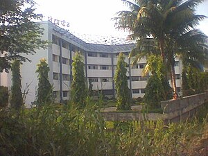
Bharati Vidyapeeth College of Engineering
College in Navi Mumbai, India
Distance: Approx. 3017 meters
Latitude and longitude: 19.026232,73.055246
Bharati Vidyapeeth College of Engineering (BVCoE) is a private engineering college in Kharghar, Navi Mumbai, India, established in the year 1990. The campus is located in CBD Belapur and is founded by the Bharati Vidyapeeth group. The college is permanently affiliated to University Of Mumbai and approved by All India Council for Technical Education (AICTE), New Delhi.

Taloje Panchnand
Node of Navi Mumbai in Maharashtra, India
Distance: Approx. 4034 meters
Latitude and longitude: 19.0833,73.0833
Taloja is a census town in Raigad district of Navi Mumbai city in the Indian state of Maharashtra. It is an extension of the Kharghar node and governed by Panvel Municipal Corporation. Taloja has Navi Mumbai Metro Phase I starting origin point at Pendhar.
Cross Cafe
Adolf-Hitler themed restaurant in Kharghar in Navi Mumbai
Distance: Approx. 1980 meters
Latitude and longitude: 19.0343116,73.0635185
Cross Cafe, formerly known as Hitlers' Cross or Hitler's Cross, was an Adolf Hitler-themed restaurant at Kharghar in Navi Mumbai, a satellite city of Mumbai. The restaurant's former name, "Hitlers' Cross", referred to the swastika and the Cross of Honour of the German Mother, symbols of the Nazi regime, and the restaurant's interior was decorated in red, white and black - the colours of the Nazi party. An enormous portrait of Hitler was the first thing visitors saw when they opened the door.
Bharati Vidyapeeth Institute of Technology
Distance: Approx. 2990 meters
Latitude and longitude: 19.026511,73.055166
Bharati Vidyapeeth Institute of Technology (BVIT) is a polytechnic college in Navi Mumbai. It is located in CBD Belapur, but closer to Kharghar, being situated opposite to the Kharghar railway station.
Kendriya Vihar
Distance: Approx. 2173 meters
Latitude and longitude: 19.04,73.08
Kendriya Vihar, is a housing complex in Kharghar, Navi Mumbai developed by CGEWHO (Central Government Employees Welfare Housing Organisation), an autonomous society of Central Government, which takes care of housing of Central Government employees across India. It is the biggest project of CGEWHO and is one of the best colonies in Navi Mumbai. Mostly central government present and retired employees reside there.
Rohinjan
Village in Maharashtra
Distance: Approx. 4060 meters
Latitude and longitude: 19.087,73.075
Rohinjan is a village situated in Taloja, under panvel municipal corporation Navi mumbai acquired by (CIDCO) on old mumbai pune highway Rohinjan- kiravali is situated near Kharghar it has metro and railway station at 1.5 to 2.5 km (0.93 to 1.55 mi) distance, is now a major attraction for new building projects. This area also has the tallest tower Adhiraj samyama of Navi Mumbai Raigad district in Maharashtra, India.

Central Park, Kharghar
Distance: Approx. 696 meters
Latitude and longitude: 19.057342,73.067408
The Central Park of Kharghar is an urban park in Navi Mumbai, India that covers an area of around 119 hectares (290 acres) spread across the city's sectors 23,24 and 25.
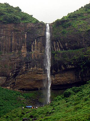
Pandavkada Falls
Waterfall in Raigad, India
Distance: Approx. 516 meters
Latitude and longitude: 19.05668,73.06303
Pandavkada Falls is a waterfall located Kharghar, a suburb of Navi Mumbai. The waterfall, about 107 metres high is a type of 'plunge' waterfall in nature pouring in massive amounts of water on the rocky surface underneath.
Greenfingers Global School
Co-education school in Navi Mumbai, Maharashtra, India
Distance: Approx. 1405 meters
Latitude and longitude: 19.04,73.06
Greenfingers Global School, often abbreviated as GFGS is a CBSE affiliated School located in Kharghar, Navi Mumbai. Green Fingers Global School was established in 2006. The school started its first session in the year 2006–2007.
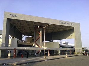
Kharghar railway station
Railway Station in Maharashtra, India
Distance: Approx. 2964 meters
Latitude and longitude: 19.02583333,73.05916667
Kharghar is the fourth railway station from Panvel on the Harbour Line of the Mumbai Suburban Railway network. Local trains of the Harbour Line in the Central Railway ply between Panvel and Chhatrapati Shivaji Maharaj Terminus stations and the Western line is connected through the Vadala station. It takes about 65 minutes to reach Kharghar by suburban train from Chhatrapati Shivaji Maharaj Terminus.
Taloja Central Jail
Prison in Kharghar, Maharashtra, India.
Distance: Approx. 2922 meters
Latitude and longitude: 19.078,73.0683
Taloja Central Jail is a prison in Taloja near Taloja Panchnand railway station on the outskirts of Kharghar, a suburb of the city of Mumbai in the state of Maharashtra in India. It was opened in 2008 and has capacity for 3000 inmates. The Indian Jesuit Roman Catholic priest and tribal rights activist Stan Swamy was held there preceding his death in 2021.
Weather in this IP's area
overcast clouds
27 Celsius
30 Celsius
27 Celsius
27 Celsius
1008 hPa
84 %
1008 hPa
1006 hPa
10000 meters
1.41 m/s
1.56 m/s
137 degree
91 %
06:26:08
18:37:00