Country:
 India
IndiaRegion:
City:
Latitude and Longitude:
Time Zone:
Postal Code:
IP information under different IP Channel
ip-api
Country
Region
City
ASN
Time Zone
ISP
Blacklist
Proxy
Latitude
Longitude
Postal
Route
IPinfo
Country
Region
City
ASN
Time Zone
ISP
Blacklist
Proxy
Latitude
Longitude
Postal
Route
MaxMind
Country
Region
City
ASN
Time Zone
ISP
Blacklist
Proxy
Latitude
Longitude
Postal
Route
Luminati
Country
INRegion
mh
City
mumbai
ASN
Time Zone
Asia/Kolkata
ISP
Mahanagar Telephone Nigam Limited
Latitude
Longitude
Postal
db-ip
Country
Region
City
ASN
Time Zone
ISP
Blacklist
Proxy
Latitude
Longitude
Postal
Route
ipdata
Country
Region
City
ASN
Time Zone
ISP
Blacklist
Proxy
Latitude
Longitude
Postal
Route
Popular places and events near this IP address
Rajiv Gandhi Medical College
Medical College & Hospital in Kalwa, Thane, Maharashtra, India
Distance: Approx. 1483 meters
Latitude and longitude: 19.192419,72.986746
Rajiv Gandhi Medical College and Chhatrapati Shivaji Maharaj Hospital is a school of medicine, established in 1992 and based in Kalwa, Thane, Maharashtra, India.
Kalwa, Thane
Suburb in Thane, Maharashtra, India
Distance: Approx. 214 meters
Latitude and longitude: 19.19705,72.99853
Kalwa (Pronunciation: [kəɭʋaː]) is a neighborhood in Thane city ]] administered under Thane Municipal Corporation in Thane district, in the State of Maharashtra, India. The nearest railway station is the Kalwa railway station on the Central Line of the Mumbai Suburban Railway. Previously, Kalwa railway station had 2 platforms but now it has increased to 4.

Dadoji Kondadev Stadium
Stadium in Maharashtra, India
Distance: Approx. 2198 meters
Latitude and longitude: 19.19244722,72.97975833
The Dadoji Konddev Stadium, sometimes called SR Bhosle Krida Sankul Stadium, is a sports stadium in Thane, Maharashtra, India. It is named after Dadoji Konddev and is currently used mostly for training. Its main ground has been built for cricket with an in-built six lane running track for athletes.
St. John the Baptist High School, Thane
School
Distance: Approx. 2617 meters
Latitude and longitude: 19.195228,72.975424
St. John the Baptist High School and Junior College is a Catholic school in the city of Thane, Maharashtra, India dedicated to St. John the Baptist.

Holy Cross Convent High School, Thane
School for girls in Maharashtra, India
Distance: Approx. 2415 meters
Latitude and longitude: 19.204225,72.978997
Holy Cross Convent High School & junior college is an all-girls school located in K'Villa, Thane, Maharashtra, India. It was founded in 1964 and celebrated its Golden Jubilee in 2014. The medium of instruction is English.
Brindaban Society
Distance: Approx. 2150 meters
Latitude and longitude: 19.20831,72.984452
Vrindavan Society (or Brindaban Society or Vrundavan Society) is a large residential complex in Thane, Maharashtra, India, developed by a venture of Mittal and Raheja Developers. The first building in this 100+ apartment building complex was constructed in 1984 and the project was completed in the early 90s.

Mumbra-Kalwa Assembly constituency
Constituency of the Maharashtra legislative assembly in India
Distance: Approx. 2632 meters
Latitude and longitude: 19.1812027,72.9808599
Mumbra-Kalwa is one of the 288 Vidhan Sabha (Assembly) constituencies of Maharashtra state in Western India.

Kopineshwar Mandir, Thane
Ancient Hindu temple in Thane (India)
Distance: Approx. 2474 meters
Latitude and longitude: 19.193,72.977
Kopineshwar Mandir (also Kaupīnēśvar Mandir) (Marathi: कौपिनेश्वर मंदिर) is a temple dedicated to the Hindu god Shiva and is considered the patron god of Thane. The Shivalinga inside the temple is considered one of the largest in Maharashtra, India.
Digha, Navi Mumbai
A small township near Airoli in Navi Mumbai, India.
Distance: Approx. 1740 meters
Latitude and longitude: 19.181084,72.995696
Digha (Dighe, Digha Talav) is a small township near Airoli in Navi Mumbai, India. Digha is in district Thane. Its Postal Index Number is 400708.
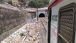
Parsik Tunnel
Railway tunnel in India
Distance: Approx. 1771 meters
Latitude and longitude: 19.18871,73.015214
The Parsik Tunnel is a 1.31678 km (0.81821 mi) long electrified dual-line railway tunnel located in Parsik Hill to the east of Thane, Maharashtra. It is a part of the Central line. This tunnel bypasses the Kalwa and Mumbra railway stations, making it a fast line between Thane and Diva Junction.
Dnyaneshwar Dnyan Mandir High School And Junior College
Private school in Thane, Maharashtra, India
Distance: Approx. 2690 meters
Latitude and longitude: 19.1985423,72.9748449
Dnyaneshwar Dnyan Mandir English High School, Thane was established in the year 1975, and in 2010, the new management of Goodwill International Foundation Trust (GIFT) took over the school. The President of the Trust and Board of Governors is Mrs. Nandini R. Vichare.
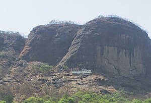
Mumbra Devi Temple
Hindu temple in Maharashtra, India
Distance: Approx. 1968 meters
Latitude and longitude: 19.1934,73.0188
Mumbra Devi Temple is an old Hindu temple situated at the top of Parsik Hill in Mumbra, a suburb of Thane district, near Mumbai, India. The temple is located on the hill, approximately 210 meters from sea level. Mumbra Devi Temple has idols of nine goddesses.
Weather in this IP's area
mist
27 Celsius
30 Celsius
27 Celsius
27 Celsius
1008 hPa
78 %
1008 hPa
1007 hPa
3000 meters
75 %
06:26:22
18:37:17