Country:
 India
IndiaRegion:
City:
Latitude and Longitude:
Time Zone:
Postal Code:
IP information under different IP Channel
ip-api
Country
Region
City
ASN
Time Zone
ISP
Blacklist
Proxy
Latitude
Longitude
Postal
Route
IPinfo
Country
Region
City
ASN
Time Zone
ISP
Blacklist
Proxy
Latitude
Longitude
Postal
Route
MaxMind
Country
Region
City
ASN
Time Zone
ISP
Blacklist
Proxy
Latitude
Longitude
Postal
Route
Luminati
Country
INRegion
mh
City
mumbai
ASN
Time Zone
Asia/Kolkata
ISP
Mahanagar Telephone Nigam Limited
Latitude
Longitude
Postal
db-ip
Country
Region
City
ASN
Time Zone
ISP
Blacklist
Proxy
Latitude
Longitude
Postal
Route
ipdata
Country
Region
City
ASN
Time Zone
ISP
Blacklist
Proxy
Latitude
Longitude
Postal
Route
Popular places and events near this IP address
Dombivli
City in Maharashtra, India
Distance: Approx. 1774 meters
Latitude and longitude: 19.218433,73.086718
Dombivli (pronunciation: [ɖoːmbiʋliː]) is a suburban city located on the banks of Ulhas River in Thane district of Maharashtra, India. It is part of Mumbai Metropolitan Region. One of the busiest railway stations of the Central Railway, Dombivli Railway Station is located here making Dombivli an important place.
Thakurli
Village in Maharashtra
Distance: Approx. 1269 meters
Latitude and longitude: 19.225507,73.09673
Thakurli is a suburb of the Kalyan Dombivli Municipal Corporation in India. Thakurli is situated between Dombivli and Kalyan. Served by Thakurli railway station, it used to be a British railway colony, and one can find old bungalows of railways.
Shivajirao S Jondhale College of Engineering
Private school in Dombivli, Maharashtra, India
Distance: Approx. 1344 meters
Latitude and longitude: 19.204736,73.107997
Shivajirao S. Jondhale College of Engineering (SSJCOE), is an engineering college located in Dombivli in Thane, Maharastra. SSJCOE is a private engineering college founded in 1994-95. The college has six departments: Computer Engineering, Information technology, Chemical Engineering, Electronics and Telecommunications Engineering, Mechanical Engineering and Artificial Intelligence and Machine Learning.
Kalyan Lok Sabha constituency
Lok Sabha constituency in Maharashtra
Distance: Approx. 1817 meters
Latitude and longitude: 19.2,73.1
Kalyan Lok Sabha constituency is one of the 48 Lok Sabha (lower house of the Indian Parliament) constituencies in Maharashtra state in western India. This constituency was created on 19 February 2008 as a part of the implementation of the Presidential notification based on the recommendations of the Delimitation Commission of India constituted on 12 July 2002. It first held elections in 2009 and its first member of parliament (MP) was Anand Paranjpe of Shiv Sena.

Ulhasnagar Assembly constituency
Constituency of the Maharashtra legislative assembly in India
Distance: Approx. 2516 meters
Latitude and longitude: 19.22413889,73.12573056
Ulhasnagar Assembly constituency is one of the 288 Vidhan Sabha (Legislative Assembly) constituencies of Maharashtra state in western India. The constituency is dominated by Sindhi the community.
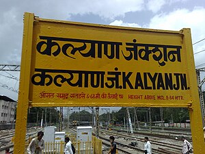
Kalyan Junction railway station
Railway junction station in Thane district, Maharashtra, India
Distance: Approx. 3565 meters
Latitude and longitude: 19.23525,73.1305
Kalyan Junction is a major railway junction station on the central line of the Mumbai Suburban Railway network, lying at the junction of the north-east and south-east lines of the suburban Mumbai division of the Central Railway, 54 km (34 mi) north-east of Mumbai. It comes under top 10 busiest railway stations in India. Kalyan Junction is an important stop for all the trains.
G. R. Patil College
Distance: Approx. 2104 meters
Latitude and longitude: 19.197299,73.10051
G. R. College of Dombivli, Mumbai is a higher secondary and degree college. It provides education for HSC and Bachelor's degree in Science, Commerce and Art. The college is managed by Mumbra Shikshan Prasarak Mandal (which has other educational institutes).

Kalyan East Assembly constituency
Constituency of the Maharashtra legislative assembly in India
Distance: Approx. 2266 meters
Latitude and longitude: 19.222,73.124
Kalyan East Assembly constituency is one of the 288 Vidhan Sabha (legislative assembly) constituencies of Maharashtra state, western India. This constituency is located in Thane district.

Dombivli Assembly constituency
Constituency of the Maharashtra legislative assembly in India
Distance: Approx. 1559 meters
Latitude and longitude: 19.21,73.09
Dombivli Assembly constituency is one of the 288 Vidhan Sabha (legislative assembly) constituencies of Maharashtra state, western India. This constituency is located in Thane district.

Electric Loco Shed, Kalyan
Loco shed in Maharashtra, India
Distance: Approx. 3565 meters
Latitude and longitude: 19.23525,73.1305
Electric Loco Shed, Kalyan is an electric engine shed located in Kalyan in the Indian state of Maharashtra. Located north-east of Kalyan Junction railway station, it falls under the Mumbai CR railway division. The Loco Shed will be remodeled into Platforms.
Nandiwali Tarf Pachanand
Village in Maharashtra, India
Distance: Approx. 3059 meters
Latitude and longitude: 19.21222222,73.13222222
Nandiwali Tarf Pachanand is a village in Kalyan Taluka, Thane District, Maharashtra, India. It is located near the western coast of India, about 14 kilometres east of the district capital Thane, and 3 kilometres south of the taluka capital Kalyan. In 2011, its population is 36,163.
Pisawali
Village in Maharashtra, India
Distance: Approx. 2390 meters
Latitude and longitude: 19.215,73.12611111
Pisawali, also known as Pisavli, is a village in Kalyan taluka of Thane district, in the Maharashtra state of India. It is situated on the outskirts of the city Kalyan, about 3 kilometres south of the city center. Its population was 31,202 according to the 2011 census.
Weather in this IP's area
scattered clouds
27 Celsius
30 Celsius
27 Celsius
27 Celsius
1007 hPa
86 %
1007 hPa
1005 hPa
10000 meters
0.93 m/s
1.03 m/s
117 degree
38 %
06:25:57
18:36:52