182.252.76.68 - IP Lookup: Free IP Address Lookup, Postal Code Lookup, IP Location Lookup, IP ASN, Public IP
Country:
Region:
City:
Location:
Time Zone:
Postal Code:
ISP:
ASN:
language:
User-Agent:
Proxy IP:
Blacklist:
IP information under different IP Channel
ip-api
Country
Region
City
ASN
Time Zone
ISP
Blacklist
Proxy
Latitude
Longitude
Postal
Route
db-ip
Country
Region
City
ASN
Time Zone
ISP
Blacklist
Proxy
Latitude
Longitude
Postal
Route
IPinfo
Country
Region
City
ASN
Time Zone
ISP
Blacklist
Proxy
Latitude
Longitude
Postal
Route
IP2Location
182.252.76.68Country
Region
rajshahi
City
nawabganj
Time Zone
Asia/Dhaka
ISP
Language
User-Agent
Latitude
Longitude
Postal
ipdata
Country
Region
City
ASN
Time Zone
ISP
Blacklist
Proxy
Latitude
Longitude
Postal
Route
Popular places and events near this IP address

Chapai Nawabganj Sadar Upazila
Upazila in Rajshahi, Bangladesh
Distance: Approx. 1083 meters
Latitude and longitude: 24.6,88.26666667
Nawabganj Sadar (Bengali: নবাবগঞ্জ সদর) is an upazila of Nawabganj District in the Division of Rajshahi, Bangladesh.

Chapai Nawabganj
City in Rajshahi, Bangladesh
Distance: Approx. 203 meters
Latitude and longitude: 24.591,88.269
Chapai Nawabganj is a town in north-western Bangladesh. It is the headquarters of Chapai Nawabganj District. It is located on the banks of the Mahananda River.
Chapai Nawabganj Stadium
Distance: Approx. 1465 meters
Latitude and longitude: 24.59410278,88.25690556
Chapai Nawabganj Stadium is located by the PTI Bishwa Rd, Nawabganj, Bangladesh.

Don Bosco English Medium School Monigram
School
Distance: Approx. 8431 meters
Latitude and longitude: 24.57055556,88.19083333
Don Bosco English Medium School Monigram, or DBEMS, is a co-educational English medium school established in 2005. It is run by the Roman Catholic Diocese of Krishnagar. The school operates under the Indian Certificate of Secondary Education in rural Murshidabad.
Exim Bank Agricultural University Bangladesh
Private agricultural university in Chapainawabganj, Bangladesh
Distance: Approx. 651 meters
Latitude and longitude: 24.5969,88.2702
EXIM Bank Agricultural University Bangladesh (Bengali: এক্সিম ব্যাংক কৃষি বিশ্ববিদ্যালয় বাংলাদেশ) is the first private agricultural university in Bangladesh.

Chapai Nawabganj-3
Constituency of Bangladesh's Jatiya Sangsad
Distance: Approx. 1346 meters
Latitude and longitude: 24.6,88.28
Chapai Nawabganj-3 is a constituency represented in the Jatiya Sangsad (National Parliament) of Bangladesh. Since 6 August 2024 the constituency is vacant.
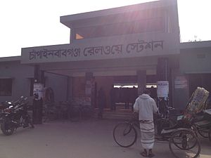
Chapainawabganj railway station
Distance: Approx. 1267 meters
Latitude and longitude: 24.59902,88.279992
Chapainawabganj railway station is a railway station in Chapai Nawabganj. This is a terminus station of Old Malda–Abdulpur line.
Weather in this IP's area
clear sky
19 Celsius
19 Celsius
19 Celsius
19 Celsius
1012 hPa
43 %
1012 hPa
1009 hPa
10000 meters
2.98 m/s
3.03 m/s
345 degree
