182.232.119.65 - IP Lookup: Free IP Address Lookup, Postal Code Lookup, IP Location Lookup, IP ASN, Public IP
Country:
 Thailand
Region:
City:
Location:
Time Zone:
Postal Code:
ISP:
ASN:
language:
User-Agent:
Proxy IP:
Blacklist:
IP information under different IP Channel
ip-api
Country
Region
City
ASN
Time Zone
ISP
Blacklist
Proxy
Latitude
Longitude
Postal
Route
db-ip
Country
Region
City
ASN
Time Zone
ISP
Blacklist
Proxy
Latitude
Longitude
Postal
Route
IPinfo
Country
Region
City
ASN
Time Zone
ISP
Blacklist
Proxy
Latitude
Longitude
Postal
Route
IP2Location
182.232.119.65Country
thRegion
chiang rai
City
wiang chai
Time Zone
Asia/Bangkok
ISP
Language
User-Agent
Latitude
Longitude
Postal
ipdata
Country
Region
City
ASN
Time Zone
ISP
Blacklist
Proxy
Latitude
Longitude
Postal
Route
Popular places and events near this IP address

Wiang Chai district
District in Chiang Rai, Thailand
Distance: Approx. 61 meters
Latitude and longitude: 19.88305556,99.93305556
Wiang Chai (Thai: เวียงชัย, IPA: [wīaŋ tɕʰāj]; Northern Thai: เวียงจัย, IPA: [wīaŋ tɕāj]) is a district (amphoe) in the central part of Chiang Rai province, northern Thailand.

Wiang Chai subdistrict
Tambon in Thailand
Distance: Approx. 38 meters
Latitude and longitude: 19.88333333,99.93333333
Wiang Chai Subdistrict (Thai: เวียงชัย) is a village and tambon (subdistrict) of Wiang Chai District, in Chiang Rai Province, Thailand. In 2005 it had a population of 11,117 people. The tambon contains 20 villages.
Wiang Nuea, Chiang Rai
Tambon in Thailand
Distance: Approx. 2550 meters
Latitude and longitude: 19.9065,99.9324
Wiang Nuea, Chiang Rai (Thai: เวียงเหนือ) is a village and tambon (subdistrict) of Wiang Chai District, in Chiang Rai Province, Thailand. In 2005 it had a population of 6,574 people. The tambon contains 12 villages.

Lao River (Thailand)
River in Chiang Rai Province, Thailand
Distance: Approx. 5942 meters
Latitude and longitude: 19.92638889,99.89916667
The Lao River or Mae Lao River (Thai: น้ำแม่ลาว, RTGS: Nam Mae Lao, pronounced [náːm mɛ̂ː lāːw]) is a river in Chiang Rai Province, Northern Thailand. It is a tributary of the Kok River, with its mouth near Sum Pratu in Mueang Chiang Rai District. This river gives its name to the Mae Lao District.
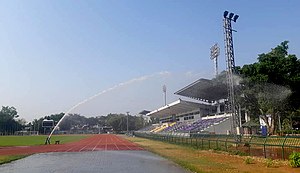
Chiangrai Province Stadium
Multi-purpose stadium in Thailand
Distance: Approx. 8782 meters
Latitude and longitude: 19.913319,99.855377
Chiangrai Province Stadium or Chiangrai Provincial Administrative Organization Stadium (Thai: สนามกีฬากลาง จ.เชียงราย หรือ สนามกีฬา อบจ. เชียงราย) is a multi-purpose stadium in Chiang Rai Province, Thailand. It is currently used mostly for football matches and is the home stadium of Chiangrai City.
Roman Catholic Diocese of Chiang Rai
Roman Catholic diocese in Thailand
Distance: Approx. 9910 meters
Latitude and longitude: 19.913928,99.844083
The Roman Catholic Diocese of Chiang Rai (Dioecesis Chiangraiensis) is in northern Thailand. It is a suffragan diocese of the Archdiocese of Bangkok. The diocese covers an area of 37,839 km2, covering four provinces: Chiang Rai, Nan, Phayao, Phrae and Ngao District of the Lampang Province.
Weather in this IP's area
broken clouds
17 Celsius
17 Celsius
16 Celsius
18 Celsius
1013 hPa
99 %
1013 hPa
962 hPa
7000 meters
78 %