Country:
Region:
City:
Latitude and Longitude:
Time Zone:
Postal Code:
IP information under different IP Channel
ip-api
Country
Region
City
ASN
Time Zone
ISP
Blacklist
Proxy
Latitude
Longitude
Postal
Route
Luminati
Country
Region
dc
City
bogota
ASN
Time Zone
America/Bogota
ISP
IFX18747
Latitude
Longitude
Postal
IPinfo
Country
Region
City
ASN
Time Zone
ISP
Blacklist
Proxy
Latitude
Longitude
Postal
Route
db-ip
Country
Region
City
ASN
Time Zone
ISP
Blacklist
Proxy
Latitude
Longitude
Postal
Route
ipdata
Country
Region
City
ASN
Time Zone
ISP
Blacklist
Proxy
Latitude
Longitude
Postal
Route
Popular places and events near this IP address
Antonio Nariño, Bogotá
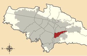
Locality of Bogotá in Bogotá D.C., Colombia
Distance: Approx. 3392 meters
Latitude and longitude: 4.58416667,-74.11305556
Antonio Nariño is the 15th locality of Bogotá, capital of Colombia. It is located in the central part of the city. This district is mostly inhabited by middle class residents.

General Santander National Police Academy
Police academy in Colombia
Distance: Approx. 4036 meters
Latitude and longitude: 4.59027778,-74.13027778
General Santander National Police Academy (or Escuela General Santander de la Policia Nacional in Spanish) is the main educational center for the Colombian National Police. The academy functions as a university for the formation of its force.

Tunjuelito
Locality of Bogotá in Bogotá D.C., Colombia
Distance: Approx. 3229 meters
Latitude and longitude: 4.58222222,-74.13194444
Tunjuelito is the 6th locality of the Capital District of the Colombian capital, Bogotá. Tunjuelito is located in the south of Bogotá, bordering to the north with the localities of Bosa, Kennedy and Puente Aranda, to the east with the localities of Rafael Uribe Uribe and Usme, to the south with Usme and to the west with Ciudad Bolívar. This district is mostly inhabited by working and lower class residents.

Rafael Uribe Uribe, Bogotá
Locality of Bogotá in Bogotá D.C., Colombia
Distance: Approx. 2795 meters
Latitude and longitude: 4.57972222,-74.1175
Rafael Uribe Uribe is the 18th locality of the Capital District in the Colombian capital Bogotá. This district is mostly inhabited by working and lower class residents. It was named after the Liberal General Rafael Uribe Uribe.

Ciudad Bolívar, Bogotá
Locality of Bogotá in Bogotá D.C., Colombia
Distance: Approx. 2824 meters
Latitude and longitude: 4.53611111,-74.13888889
Ciudad Bolívar is the 19th locality in the Capital District of the Colombian capital city Bogotá. Ciudad Bolívar is located in the south of the city at the southern border of the Bogotá savanna. This district is mostly inhabited by under privileged residents.

Centro Mayor
Shopping mall in Bogotá, Colombia
Distance: Approx. 4088 meters
Latitude and longitude: 4.59166667,-74.12388889
Centro Mayor is a shopping mall located in the south of Bogotá, Colombia. It was inaugurated on March 26, 2010. The mall has 248,000 m2 (2,667,000 sq ft) of built area, being the biggest mall in Colombia and the second one in Latin America, behind the Centro Comercial Aricanduva, in São Paulo, Brazil.

Ciudad Tunal
Barrio in Distrito Capital, Colombia
Distance: Approx. 2308 meters
Latitude and longitude: 4.57194444,-74.13388889
Ciudad Tunal is a neighbourhood (barrio) of the locality Tunjuelito in Bogotá, Colombia.
Quiroga, Bogotá
Barrio in Distrito Capital, Colombia
Distance: Approx. 3197 meters
Latitude and longitude: 4.5812,-74.1101
Quiroga is a neighbourhood (barrio) of Bogotá, Colombia.
Santa Inés, Bogotá
Barrio in Distrito Capital, Colombia
Distance: Approx. 3859 meters
Latitude and longitude: 4.5618,-74.0878
Santa Inés is a neighbourhood (barrio) of Bogotá, Colombia.
2019 Bogotá car bombing
Attack on the Colombian General Santander Police Academy
Distance: Approx. 4089 meters
Latitude and longitude: 4.59083333,-74.13
On 17 January 2019, a vehicle was driven into the General Santander National Police Academy in Bogotá, Colombia. The truck forced its way into the facility, hit a wall and detonated, killing 22 people (including the perpetrator) and injuring 68 others. Suicide attacks are unusual in Colombia.
Quebrada Limas
River in Colombia
Distance: Approx. 3555 meters
Latitude and longitude: 4.57386,-74.14775
Quebrada Limas is a small river of Bogotá that originates in the path of Quiba, in the rural part of the Ciudad Bolívar and therefore, it is a tributary of the Tunjuelo River.

Tunal library
Library in Bogotá, Colombia
Distance: Approx. 2105 meters
Latitude and longitude: 4.5721,-74.13
The Gabriel García Márquez - El Tunal Public Library, is a library located in the Tunal Park in the south of Bogotá, Colombia. It was designed by architects Suely Vargas Nóbrega, Manuel Antonio Guerrero and Marcia Wanderley and was inaugurated on May 10, 2001, forming part of the BibloRed Network of Public Libraries, and receives approximately 4,000 people of different ages daily. On June 18, 2014, by means of Agreement #556 (articles three) of the Bogotá City Council, the Library was renamed as the Gabriel García Márquez - El Tunal Public Library, to honor the Colombian writer and Nobel Prize winner.
Weather in this IP's area
thunderstorm with light rain
13 Celsius
13 Celsius
13 Celsius
13 Celsius
1015 hPa
100 %
1015 hPa
752 hPa
10000 meters
5.66 m/s
160 degree
75 %
05:42:31
17:38:18
