Country:
Region:
City:
Latitude and Longitude:
Time Zone:
Postal Code:
IP information under different IP Channel
ip-api
Country
Region
City
ASN
Time Zone
ISP
Blacklist
Proxy
Latitude
Longitude
Postal
Route
Luminati
Country
Region
bi
City
talcahuano
ASN
Time Zone
America/Santiago
ISP
Telmex Servicios Empresariales S.A.
Latitude
Longitude
Postal
IPinfo
Country
Region
City
ASN
Time Zone
ISP
Blacklist
Proxy
Latitude
Longitude
Postal
Route
db-ip
Country
Region
City
ASN
Time Zone
ISP
Blacklist
Proxy
Latitude
Longitude
Postal
Route
ipdata
Country
Region
City
ASN
Time Zone
ISP
Blacklist
Proxy
Latitude
Longitude
Postal
Route
Popular places and events near this IP address

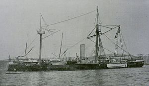
Huáscar (ironclad)
19th-century small armoured turret ship
Distance: Approx. 1390 meters
Latitude and longitude: -36.70547222,-73.11141667
Huáscar is an ironclad turret ship owned by the Chilean Navy built in 1865 for the Peruvian government. It is named after the 16th-century Inca emperor, Huáscar. She was the flagship of the Peruvian Navy and participated in the Battle of Pacocha and the War of the Pacific of 1879–1883.
Talcahuano
City in Chile
Distance: Approx. 1354 meters
Latitude and longitude: -36.71666667,-73.12194444
Talcahuano (Spanish pronunciation: [talkaˈwano]) (From Mapudungun Tralkawenu, "Thundering Sky") is a port city and commune in the Biobío Region of Chile. It is part of the Greater Concepción conurbation. Talcahuano is located in the south of the Central Zone of Chile.
Estadio Las Higueras
Distance: Approx. 4248 meters
Latitude and longitude: -36.75555556,-73.10722222
Estadio Las Higueras was a football stadium in Talcahuano, Chile. It was the home ground of Huachipato from 1960 until 2008, when it closed after its last match was played on July 19 and demolished later in the same year. The Estadio Huachipato-CAP Acero was built in its place, and it was inaugurated in 2009.

Carriel Sur International Airport
International airport in Chile
Distance: Approx. 7270 meters
Latitude and longitude: -36.7725,-73.06305556
Carriel Sur International Airport (IATA: CCP, ICAO: SCIE) is located in Talcahuano, Greater Concepción in the Bío Bío Region, 8 km (5 mi) from Concepción downtown. It is one of the largest airports in Chile and serves domestic traffic for LATAM Airlines, JetSmart and Sky Airline. It also serves as a primary alternate airport for Arturo Merino Benitez Airport, usually receiving international traffic from Santiago when that airport closes due to weather.

Greater Concepción
Place in Concepción Province, Biobío
Distance: Approx. 7392 meters
Latitude and longitude: -36.78333333,-73.11666667
Gran Concepción is the third largest conurbation in Chile, after Greater Santiago and Greater Valparaíso, with 945,650 inhabitants according to the 2012 pre census.
Club Hípico de Concepción
Horse racing venue in Hualpen, Chile
Distance: Approx. 7533 meters
Latitude and longitude: -36.78388889,-73.09111111
Club Hipico de Concepcion, also called the Mediocamino, is a Thoroughbred race track in Hualpen near Concepcion in the Bio-Bio Region of Chile. The track was opened in 1918. It features a right-handed nine-furlong dirt track.

Hualpén
City and Commune in Biobío, Chile
Distance: Approx. 8098 meters
Latitude and longitude: -36.78833333,-73.08666667
Hualpén (Spanish pronunciation: [walˈpen]) is a Chilean city and commune belonging to Concepción Province and the Biobío Region. It is part of the conurbation of Greater Concepción. The commune spans an area of 53.5 km2 (21 sq mi).

Bay of Concepción
Distance: Approx. 7575 meters
Latitude and longitude: -36.68333333,-73.03333333
The Bay of Concepción is a natural bay on the coast of the Province of Concepción in the Bío Bío Region of Chile. Within the bay are many of the most important ports of the region and the country, among them Penco, Talcahuano, and Lirquén. Quiriquina Island, located to the north in the mouth of the bay provides a windbreak.

Coliseo La Tortuga
Indoor sporting arena in Talcahuano, Chile
Distance: Approx. 331 meters
Latitude and longitude: -36.72,-73.10861111
Coliseo La Tortuga is an indoor sporting arena located in Talcahuano, Chile. The capacity of the arena is 10,000 spectators and it is used mostly for basketball. El Coliseo La Tortuga Monumental, known popularly as La Tortuga de Talcahuano, is a sports and entertainment centre, renowned for its distinctive roof, which is similar to a shell of a turtle.
Estadio Huachipato-CAP Acero
Distance: Approx. 4248 meters
Latitude and longitude: -36.75555556,-73.10722222
Estadio Huachipato-CAP Acero (Compañía de Acero del Pacífico), known until 2015 as Estadio CAP, is a football stadium located in Talcahuano, Chile. Inaugurated in 2009, it is the home field of Huachipato, replacing Estadio Las Higueras, which was demolished in 2008. The stadium capacity is 10,500 people (all-seated).
Huachipato, Chile
District in Biobío, Chile
Distance: Approx. 3490 meters
Latitude and longitude: -36.74805556,-73.09861111
Huachipato is census district and neighbourhood in Talcahuano Commune, part of the conurbation of Greater Concepción in the Biobío Region of southern Chile. It is the industrialized part of the commune supporting a steel mill and oil refinery.

Estadio El Morro
Football stadium in Talcahuano, Chile
Distance: Approx. 569 meters
Latitude and longitude: -36.7225,-73.10722222
The Estadio "El Morro" Ramón Unzaga Asla, is a stadium located in Talcahuano, Chile and has a capacity of 7,200 spectators. It is the oldest stadium in Chile and has served as the home ground for the Naval de Talcahuano football club and Huachipato Femenino since 2022.
Weather in this IP's area
clear sky
13 Celsius
13 Celsius
13 Celsius
13 Celsius
1014 hPa
94 %
1014 hPa
1014 hPa
10000 meters
5.14 m/s
230 degree
06:35:07
20:38:59

