181.64.202.239 - IP Lookup: Free IP Address Lookup, Postal Code Lookup, IP Location Lookup, IP ASN, Public IP
Country:
Region:
City:
Location:
Time Zone:
Postal Code:
IP information under different IP Channel
ip-api
Country
Region
City
ASN
Time Zone
ISP
Blacklist
Proxy
Latitude
Longitude
Postal
Route
Luminati
Country
Region
tac
City
tacna
ASN
Time Zone
America/Lima
ISP
Telefonica del Peru S.A.A.
Latitude
Longitude
Postal
IPinfo
Country
Region
City
ASN
Time Zone
ISP
Blacklist
Proxy
Latitude
Longitude
Postal
Route
IP2Location
181.64.202.239Country
Region
moquegua
City
moquegua
Time Zone
America/Lima
ISP
Language
User-Agent
Latitude
Longitude
Postal
db-ip
Country
Region
City
ASN
Time Zone
ISP
Blacklist
Proxy
Latitude
Longitude
Postal
Route
ipdata
Country
Region
City
ASN
Time Zone
ISP
Blacklist
Proxy
Latitude
Longitude
Postal
Route
Popular places and events near this IP address
Moquegua
City in Peru
Distance: Approx. 533 meters
Latitude and longitude: -17.2,-70.93333333
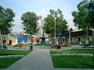
Moquegua (Spanish pronunciation: [moˈkeɣwa], founded by the Spanish colonists as Villa de Santa Catalina de Guadalcázar del Valle de Moquegua) is a city in southern Peru, located in the Department of Moquegua, of which it is the capital. It is also capital of Mariscal Nieto Province and Moquegua District. It is located 1144 kilometers south of the capital city of Lima.
Mariscal Nieto province
Province in Moquegua, Peru
Distance: Approx. 533 meters
Latitude and longitude: -17.2,-70.93333333
Mariscal Nieto (Spanish mariscal marshal) is the largest of three provinces that make up the Moquegua Region of Peru. The capital of the province is the city of Moquegua.
Moquegua District
District in Moquegua, Peru
Distance: Approx. 214 meters
Latitude and longitude: -17.1938,-70.9346
Moquegua District is one of six districts of the province Mariscal Nieto in Peru.
Samegua District
District in Moquegua, Peru
Distance: Approx. 4062 meters
Latitude and longitude: -17.1819,-70.8999
Samegua District is one of six districts of the province Mariscal Nieto in Peru.
Estadio 25 de Noviembre
Distance: Approx. 1232 meters
Latitude and longitude: -17.185731,-70.930052
Estadio 25 de Noviembre is a multi-purpose stadium in Moquegua, Peru. It is currently used by football team San Simón de Moquegua. The stadium holds 21,000 people and was built in 2009.
Cesar Torque Podesta Airport
Airport in Peru
Distance: Approx. 1898 meters
Latitude and longitude: -17.17916667,-70.93055556
Cesar Torque Podesta Airport (ICAO: SPEQ) is an airport serving the city of Moquegua, capital of the Moquegua Region of Peru.

St. Dominic Cathedral, Moquegua
Church in Moquegua, Peru
Distance: Approx. 246 meters
Latitude and longitude: -17.194,-70.9337
The St. Dominic Co-Cathedral (also known as Moquegua Cathedral; Spanish: Concatedral de Santo Domingo en Moquegua), is the main Catholic church in the city of Moquegua in Peru. It is a property of the Catholic Church.
Battle of Moquegua
Distance: Approx. 533 meters
Latitude and longitude: -17.2,-70.93333333
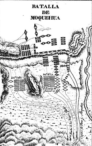
The Battle of Moquegua (or Moquehua) took place during the Peruvian War of Independence on 21 January 1823 around the city of Moquegua, between the Liberation Army of Peru, under command of Argentinean General Rudecindo Alvarado, and the Royal Army of Peru under General José de Canterac. The army of the Patriots was almost completely destroyed.
Weather in this IP's area
overcast clouds
23 Celsius
23 Celsius
23 Celsius
23 Celsius
1014 hPa
55 %
1014 hPa
823 hPa
10000 meters
3.63 m/s
2.19 m/s
205 degree
100 %


