Country:
Region:
City:
Latitude and Longitude:
Time Zone:
Postal Code:
IP information under different IP Channel
ip-api
Country
Region
City
ASN
Time Zone
ISP
Blacklist
Proxy
Latitude
Longitude
Postal
Route
Luminati
Country
Region
dc
City
bogota
ASN
Time Zone
America/Bogota
ISP
TV AZTECA SUCURSAL COLOMBIA
Latitude
Longitude
Postal
IPinfo
Country
Region
City
ASN
Time Zone
ISP
Blacklist
Proxy
Latitude
Longitude
Postal
Route
db-ip
Country
Region
City
ASN
Time Zone
ISP
Blacklist
Proxy
Latitude
Longitude
Postal
Route
ipdata
Country
Region
City
ASN
Time Zone
ISP
Blacklist
Proxy
Latitude
Longitude
Postal
Route
Popular places and events near this IP address
Guadalupe Hill
Distance: Approx. 1874 meters
Latitude and longitude: 4.59194444,-74.05416667
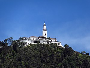
Guadalupe Hill is a 3,360-metre (11,020 ft) high hill located in the Eastern Hills, uphill from the centre of Bogotá, Colombia. Together with its neighbouring hill Monserrate it is one of the landmarks of Bogotá. At the top of the hill a hermitage and a 15-metre (49 ft) high statue has been erected.

Universidad Externado de Colombia
Distance: Approx. 3319 meters
Latitude and longitude: 4.595803,-74.06836
The Universidad Externado de Colombia (Externado University of Colombia) is a private university in Bogotá, Colombia. It has produced graduates including lawyers, academics, judges, financiers, journalists, as well as senior government officials and politicians. The institution grants 4 and 5-year professional degrees, as well as advanced Master and Doctoral degrees.

Monserrate
Mountain in Bogota, Colombia
Distance: Approx. 3339 meters
Latitude and longitude: 4.60583333,-74.05638889
Monserrate (named after Catalan homonym mountain Montserrat) is a mountain over 3,000 metres (10,000 feet) high that overlooks the city center of Bogotá, the capital city of Colombia. It rises to 3,152 meters (10,341 ft) above the sea level, where there is a church (built in the 17th century) with a shrine, devoted to El Señor Caído ("The Fallen Lord"). The Mountain, already considered sacred in pre-Columbian times when the area was inhabited by the indigenous Muisca, is a pilgrim destination, as well as a major tourist attraction.
Teleférico de Monserrate
Tourist cable car in Bogotá
Distance: Approx. 3328 meters
Latitude and longitude: 4.60305556,-74.06111111
The Teleférico de Monserrate is a tourist cable car that connects Bogotá with the Monserrate hill.

Free and Independent State of Cundinamarca
1810–1815 rebel state in colonial Colombia
Distance: Approx. 2572 meters
Latitude and longitude: 4.58333333,-74.06666667
The Free and Independent State of Cundinamarca (Spanish: Estado Libre e Independiente de Cundinamarca) was a rebel state in colonial Colombia. It included parts of the former New Kingdom of Granada (part of the Viceroyalty of New Granada). The state originated as a result of the Foolish Fatherland (Patria Boba) period at the beginning of the Spanish American wars of independence.
Laches, Bogotá
Barrio in Distrito Capital, Colombia
Distance: Approx. 2499 meters
Latitude and longitude: 4.585,-74.06555556
Laches is a neighbourhood (barrio) of Bogotá, Colombia. It is in the Santa Fe district in east-central Bogotá, on the edge of the forest reserve. In fact, some 4,500 inhabitants, mostly from the poorer strata of society, live in the forest reserve area in illegal dwellings.

Bogotá Province
Distance: Approx. 2575 meters
Latitude and longitude: 4.5833,-74.0667
The province of Santafé de Bogotá, also known as the government of Santafé during the Spanish imperial era, was originally an administrative and territorial entity of the New Kingdom of Granada. It was created on July 17th, 1550, at which point New Granada was a province within the Viceroyalty of Peru. In 1717, province became part of Viceroyalty of New Granada after King Philip V of Spain issued a real cédula creating the new viceroyalty.

Monserrate Sanctuary
Distance: Approx. 3230 meters
Latitude and longitude: 4.6052,-74.0554
Monserrate Sanctuary is a Catholic shrine in Bogotá, Colombia. The sanctuary was built between 1650 and 1657 and is 3,152 metres (10,341 ft) above sea level.

Eastern Hills (Bogotá)
Chain of hills forming Bogotá's eastern boundary
Distance: Approx. 3080 meters
Latitude and longitude: 4.60583333,-74.03972222
The Eastern Hills (Spanish: Cerros Orientales) are a chain of hills forming the eastern natural boundary of the Colombian capital Bogotá. They are part of the Altiplano Cundiboyacense, the high plateau of the Eastern Ranges of the Colombian Andes. The Eastern Hills are bordered by the Chingaza National Natural Park to the east, the Bogotá savanna to the west and north, and the Sumapaz Páramo to the south.
Fucha River
River in Cundinamarca, Colombia
Distance: Approx. 2845 meters
Latitude and longitude: 4.56333333,-74.06463889
The Fucha River is a river on the Bogotá savanna and a left tributary of the Bogotá River. The river originates in the Eastern Hills of the Colombian capital Bogotá and flows westward through the city into the Bogotá River. It is one of the three important rivers of the city, together with the Tunjuelo and Juan Amarillo Rivers.
Teusacá River
River in Colombia
Distance: Approx. 2410 meters
Latitude and longitude: 4.56313889,-74.02869444
The Teusacá River is a river in the Eastern Hills of Bogotá and on the Bogotá savanna. It is a left tributary of the Bogotá River, Colombia. The river of 69 kilometres (43 mi) long originates at an elevation of 3,560 metres (11,680 ft) at the Alto Los Tunjos, Santa Fe, and flows northward through the municipalities La Calera, Guasca, Sopó, to flow into the Bogotá River in Cajicá at an elevation of 2,554 metres (8,379 ft).
Guadalupe Group
Distance: Approx. 1874 meters
Latitude and longitude: 4.59194444,-74.05416667
The Guadalupe Group (Spanish: Grupo Guadalupe, K2G, Ksg) is a geological group of the Altiplano Cundiboyacense, Eastern Ranges of the Colombian Andes. The group, a sequence of shales and sandstones, is subdivided into three formations; Arenisca Dura, Plaeners and Arenisca Labor-Tierna, and dates to the Late Cretaceous period; Campanian-Maastrichtian epochs and at its type section has a thickness of 750 metres (2,460 ft).
Weather in this IP's area
broken clouds
8 Celsius
8 Celsius
7 Celsius
8 Celsius
1016 hPa
100 %
1016 hPa
695 hPa
10000 meters
1.03 m/s
75 %
05:44:32
17:38:41


