Country:
Region:
City:
Latitude and Longitude:
Time Zone:
Postal Code:
IP information under different IP Channel
ip-api
Country
Region
City
ASN
Time Zone
ISP
Blacklist
Proxy
Latitude
Longitude
Postal
Route
Luminati
Country
Region
l
City
merida
ASN
Time Zone
America/Caracas
ISP
Corporacion Telemic C.A.
Latitude
Longitude
Postal
IPinfo
Country
Region
City
ASN
Time Zone
ISP
Blacklist
Proxy
Latitude
Longitude
Postal
Route
db-ip
Country
Region
City
ASN
Time Zone
ISP
Blacklist
Proxy
Latitude
Longitude
Postal
Route
ipdata
Country
Region
City
ASN
Time Zone
ISP
Blacklist
Proxy
Latitude
Longitude
Postal
Route
Popular places and events near this IP address
University of the Andes (Venezuela)
Public university in Venezuela
Distance: Approx. 3828 meters
Latitude and longitude: 8.61833333,-71.13944444
The University of the Andes (Spanish: Universidad de Los Andes, ULA) is the second-oldest university in Venezuela, whose main campus is located in the city of Mérida, Venezuela. ULA is the largest public university in the Venezuelan Andes, having one of the largest student bodies in the country.
Estadio Guillermo Soto Rosa
Distance: Approx. 1494 meters
Latitude and longitude: 8.6,-71.15
Estadio Guillermo Soto Rosa is a multi-use stadium in Mérida, Venezuela. It is currently used mostly for football matches and was the home stadium of Estudiantes de Mérida Fútbol Club until Estadio Metropolitano de Mérida opened in 2005. It currently hosts the home matches of the ULA football team.

Estadio Metropolitano de Mérida
Distance: Approx. 7380 meters
Latitude and longitude: 8.55638889,-71.21666667
The Estadio Olimpico Metropolitano de Mérida or Estadio Metropolitano is a soccer stadium located in the city of Mérida in Venezuela. It was built to be one venues of the 2007 Copa América and it would also serve as one of the venues for the National Games of Venezuela Andes 2005. The stadium is part of a major sports complex, called Cinco Águilas Blancas located in the south of the city, in a zone called Urbanizacion Hacienda.
Mérida, Mérida
Capital of the state of Mérida Venezuela
Distance: Approx. 1494 meters
Latitude and longitude: 8.6,-71.15
Mérida, officially known as Santiago de los Caballeros de Mérida, is the capital of the municipality of Libertador and the state of Mérida, and is one of the main cities of the Venezuelan Andes. It was founded in 1558 by Captain Juan Rodríguez Suárez, forming part of Nueva Granada, but later became part of the Captaincy General of Venezuela and played an active role in the War of Independence. The capital city's population is 204,879 inhabitants, and the metropolitan area, that includes the municipality of Libertador, reaches 345,489 people (Census 2001).
Alberto Carnevalli Airport
Airport
Distance: Approx. 874 meters
Latitude and longitude: 8.58222222,-71.16111111
Alberto Carnevalli Airport (IATA: MRD, ICAO: SVMD) is an airport located 3 km (1.9 mi) southwest of downtown Mérida, the capital of Mérida State in Venezuela. It is named in honor of Alberto Carnevalli (es), a Venezuelan lawyer and political activist. The airport is in the Chama River valley in the Andean mountains, surrounded by higher terrain in all quadrants.

Roman Catholic Archdiocese of Mérida in Venezuela
Roman Catholic archdiocese in Venezuela
Distance: Approx. 1833 meters
Latitude and longitude: 8.59722222,-71.14388889
The Roman Catholic Archdiocese of Mérida (Latin: Archidioecesis Emeritensis in Venetiola) is a Latin Rite Metropolitan Archdiocese in western Venezuela. Its cathedral archiepiscopal see is Catedral Basílica Menor de la Inmaculada Concepción de Mérida, a minor basilica located in the city of Mérida. It also has the Minor Basilica of Santa Lucía, in Timotes town, Miranda, Mérida municipality.

Bailadores
Place in Venezuela
Distance: Approx. 1494 meters
Latitude and longitude: 8.6,-71.15
Bailadores is a town in the western part of the Mérida State of Venezuela and is the capital of the Rivas Dávila Municipality.

Mérida Province (Venezuela)
Province of Gran Colombia (1811-30); province of Venezuela (1830-64)
Distance: Approx. 3018 meters
Latitude and longitude: 8.6,-71.13333333
Mérida Province (1811 - 1864) was one of the provinces of Gran Colombia, until the independence of Venezuela in 1830, when it became one of the Provinces of Venezuela. In Gran Colombia it belonged to the Zulia Department which was created in 1824. Following the Federal War the States of Venezuela were created in 1864, and the Province was replaced by the state of Mérida.
Botanical Garden of Mérida
Distance: Approx. 4363 meters
Latitude and longitude: 8.62583333,-71.14333333
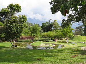
The Botanical Garden of Mérida (Spanish: Centro Jardín Botánico de Mérida) is a botanical garden in the city of Mérida in Venezuela. It was founded in 1991 by the University of the Andes, which is based in Mérida, in order to promote conservation and research in relation to the fauna and flora of the Venezuelan Andes. The garden was opened to the public on December 8, 2002.- It occupies an area of 44 hectares, donated by the university for its development.

Heladería Coromoto
Distance: Approx. 1216 meters
Latitude and longitude: 8.59436,-71.14871
Heladería Coromoto, commonly known as Coromoto, is an ice cream parlor in Merida, Venezuela, known for offering 860 flavors, a former Guinness World Record. However, it was topped by a record of 985 ice cream flavors by Matt and Mike Casarez of Migg and Mutts Craft Creamery in Black Hawk, Colorado, USA on July 17, 2011. Coromoto was established by Manuel da Silva Oliveira, who began his ice cream career at well-established ice cream firms, before founding the store in a bid to create more appealing ice cream flavors.

Cathedral Basilica of Mérida, Venezuela
Church in Mérida, Venezuela
Distance: Approx. 1831 meters
Latitude and longitude: 8.59708,-71.14383
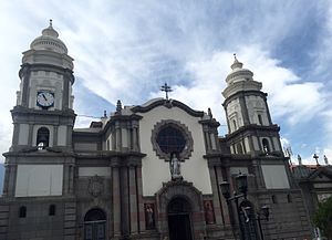
The Cathedral Basilica of the Immaculate Conception (Spanish: Catedral Basílica Menor de la Inmaculada Concepción de Mérida) or Metropolitan Cathedral of Mérida is a religious building of the Roman Catholic church located in the city of Mérida in western Venezuela, in the state of the same name, part of the Andean region in that country. It is the seat of the Archdiocese of Mérida. It was built from 1805 with various modifications until 1960.
Chorros de Milla Zoo
Zoo in Mérida, Venezuela
Distance: Approx. 4903 meters
Latitude and longitude: 8.63194444,-71.14611111
The Chorros de Milla Zoo (Spanish: Parque Zoológico Chorros de Milla) also Zoological Park of Chorros de Milla, is an urban zoological garden located in the northeastern end of the city of Mérida, Venezuela with native species of the Andean region and Venezuela. The Mérida Zoo was built in 1958 and is open to the public Tuesday to Sunday from 8:00 a.m. to 6:00 p.m.
Weather in this IP's area
overcast clouds
20 Celsius
21 Celsius
20 Celsius
20 Celsius
1014 hPa
94 %
1014 hPa
847 hPa
9222 meters
1.02 m/s
1.48 m/s
246 degree
100 %
06:37:13
18:21:17


