181.189.138.114 - IP Lookup: Free IP Address Lookup, Postal Code Lookup, IP Location Lookup, IP ASN, Public IP
Country:
Region:
City:
Location:
Time Zone:
Postal Code:
ISP:
ASN:
language:
User-Agent:
Proxy IP:
Blacklist:
IP information under different IP Channel
ip-api
Country
Region
City
ASN
Time Zone
ISP
Blacklist
Proxy
Latitude
Longitude
Postal
Route
db-ip
Country
Region
City
ASN
Time Zone
ISP
Blacklist
Proxy
Latitude
Longitude
Postal
Route
IPinfo
Country
Region
City
ASN
Time Zone
ISP
Blacklist
Proxy
Latitude
Longitude
Postal
Route
IP2Location
181.189.138.114Country
Region
quiche
City
santa cruz del quiche
Time Zone
America/Guatemala
ISP
Language
User-Agent
Latitude
Longitude
Postal
ipdata
Country
Region
City
ASN
Time Zone
ISP
Blacklist
Proxy
Latitude
Longitude
Postal
Route
Popular places and events near this IP address

Qʼumarkaj
Archeological site in Guatemala
Distance: Approx. 2604 meters
Latitude and longitude: 15.02352778,-91.17198889
Qʼumarkaj (Kʼicheʼ: [qʼumarˈkaχ]) (sometimes rendered as Gumarkaaj, Gumarcaj, Cumarcaj or Kumarcaaj) is an archaeological site in the southwest of the El Quiché department of Guatemala. Qʼumarkaj is also known as Utatlán, the Nahuatl translation of the city's name. The name comes from Kʼicheʼ Qʼumarkah "Place of old reeds".

Quiché Department
Department of Guatemala
Distance: Approx. 136 meters
Latitude and longitude: 15.03,-91.15
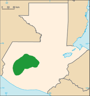
Quiché (Spanish pronunciation: [kiˈtʃe]) is a department of Guatemala. It is in the heartland of the Kʼicheʼ (Quiché) people, one of the Maya peoples, to the north-west of Guatemala City. The capital is Santa Cruz del Quiché.

Santa Cruz del Quiché
Municipality in El Quiché, Guatemala
Distance: Approx. 136 meters
Latitude and longitude: 15.03,-91.15
Santa Cruz del Quiché is a city, with a population of 78,279 (2018 census), in Guatemala. It serves as the capital of the El Quiché department and the municipal seat of Santa Cruz del Quiché municipality. The city is located at 15.03°N 91.15°W / 15.03; -91.15, at an elevation of 2,021 m (6,631 feet) above sea level.

Chiché, Guatemala
Municipality in El Quiché, Guatemala
Distance: Approx. 9292 meters
Latitude and longitude: 15.01055556,-91.065
Chiché (Spanish pronunciation: [tʃiˈtʃe])is a municipality in the Guatemalan department of El Quiché.

Patzité
Municipality in El Quiché, Guatemala
Distance: Approx. 9778 meters
Latitude and longitude: 14.96388889,-91.20805556
Patzité (Spanish pronunciation: [patsiˈte]) is a municipality in the Guatemalan department of El Quiché.
San Antonio Ilotenango
Municipality in El Quiché, Guatemala
Distance: Approx. 9057 meters
Latitude and longitude: 15.05444444,-91.22944444
San Antonio Ilotenango is a municipality in the Guatemalan department of El Quiché.
San Pedro Jocopilas
Municipality in El Quiché, Guatemala
Distance: Approx. 7203 meters
Latitude and longitude: 15.09527778,-91.15083333
San Pedro Jocopilas is a municipality in the Guatemalan department of El Quiché.

Kʼicheʼ kingdom of Qʼumarkaj
Distance: Approx. 2604 meters
Latitude and longitude: 15.02352778,-91.17198889
The Kʼicheʼ kingdom of Qʼumarkaj was a state in the highlands of modern-day Guatemala which was founded by the Kʼicheʼ (Quiché) Maya in the thirteenth century, and which expanded through the fifteenth century until it was conquered by Spanish and Nahua forces led by Pedro de Alvarado in 1524. The Kʼicheʼ kingdom reached its height under the king Kʼiqʼab who ruled from the fortified town of Qʼumarkaj (also called by its Nahuatl name Utatlán) near the modern town of Santa Cruz del Quiché. During his rule the Kʼicheʼ ruled large areas of highland Guatemala extending into Mexico, and they subdued other Maya peoples such as the Tzʼutujil, Kaqchikel and Mam, as well as the Nahuan Pipil people.
Quiché Airport
Airport in Guatemala
Distance: Approx. 2033 meters
Latitude and longitude: 15.0125,-91.15138889
Quiché Airport (IATA: AQB, ICAO: MGQC) is an airport serving Santa Cruz del Quiché, the capital of Quiché Department, Guatemala. The airport is just south of the city. The Rabinal VOR-DME is located 39.5 nautical miles (73.2 km) east of the airport.
Weather in this IP's area
clear sky
21 Celsius
21 Celsius
21 Celsius
21 Celsius
1013 hPa
42 %
1013 hPa
789 hPa
10000 meters
4.38 m/s
4.26 m/s
70 degree