181.174.85.69 - IP Lookup: Free IP Address Lookup, Postal Code Lookup, IP Location Lookup, IP ASN, Public IP
Country:
 Guatemala
Region:
City:
Location:
Time Zone:
Postal Code:
ISP:
ASN:
language:
User-Agent:
Proxy IP:
Blacklist:
IP information under different IP Channel
ip-api
Country
Region
City
ASN
Time Zone
ISP
Blacklist
Proxy
Latitude
Longitude
Postal
Route
db-ip
Country
Region
City
ASN
Time Zone
ISP
Blacklist
Proxy
Latitude
Longitude
Postal
Route
IPinfo
Country
Region
City
ASN
Time Zone
ISP
Blacklist
Proxy
Latitude
Longitude
Postal
Route
IP2Location
181.174.85.69Country
gtRegion
jutiapa
City
jutiapa
Time Zone
America/Guatemala
ISP
Language
User-Agent
Latitude
Longitude
Postal
ipdata
Country
Region
City
ASN
Time Zone
ISP
Blacklist
Proxy
Latitude
Longitude
Postal
Route
Popular places and events near this IP address

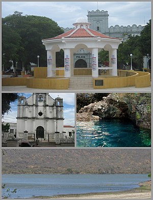
Jutiapa
Municipality in Guatemala
Distance: Approx. 811 meters
Latitude and longitude: 14.28277778,-89.8925
Jutiapa is a city and a municipality in the Jutiapa department of Guatemala. Located 124 km from the city of Guatemala City, at an altitude of 892 m (2,926 ft), it is the capital of the department of Jutiapa. Its Catedral San Cristóbal is the episcopal see of the Roman Catholic Diocese of San Francisco de Asís de Jutiapa since 2016.
Jutiapa Department
Department of Guatemala
Distance: Approx. 811 meters
Latitude and longitude: 14.28277778,-89.8925
Jutiapa Department is a department of Guatemala that borders along El Salvador and the Pacific Ocean. The capital is the city of Jutiapa. As of 2018, it has a population of 488,395.

Estadio Winston Pineda (El Cóndor)
Distance: Approx. 1449 meters
Latitude and longitude: 14.2948,-89.8937
Estadio Winston Pineda is a soccer stadium in Jutiapa, Guatemala. The stadium, also known as "El Cóndor", It opened in 1982 and is home to Liga Nacional club Achuapa and has a maximum capacity of 6,000 people.

El Progreso, Jutiapa
Municipality in Jutiapa, Guatemala
Distance: Approx. 9177 meters
Latitude and longitude: 14.35,-89.85
El Progreso (Spanish pronunciation: [el pɾoˈɣɾeso]), also El Progreso, Achuapa, is a town and municipality in the Jutiapa department of Guatemala. In 2018 the municipality had a population of 22,114 The Pan American Highway passes to the south of the main town, connecting it with Jutiapa, 11 kilometres (6.8 mi) to the southwest. The Morán, Chiquito and Ostúa rivers flow through the municipality.

Cerro Santiago
Distance: Approx. 7170 meters
Latitude and longitude: 14.34361111,-89.87666667
Cerro Santiago is one of the most prominent cinder cones of a volcanic field surrounding the city of Jutiapa in southern Guatemala. Its elevation is 1,192 m (3,911 ft).
Weather in this IP's area
clear sky
16 Celsius
16 Celsius
16 Celsius
16 Celsius
1015 hPa
85 %
1015 hPa
900 hPa
10000 meters
2.76 m/s
4.05 m/s
20 degree