181.174.74.175 - IP Lookup: Free IP Address Lookup, Postal Code Lookup, IP Location Lookup, IP ASN, Public IP
Country:
Region:
City:
Location:
Time Zone:
Postal Code:
ISP:
ASN:
language:
User-Agent:
Proxy IP:
Blacklist:
IP information under different IP Channel
ip-api
Country
Region
City
ASN
Time Zone
ISP
Blacklist
Proxy
Latitude
Longitude
Postal
Route
db-ip
Country
Region
City
ASN
Time Zone
ISP
Blacklist
Proxy
Latitude
Longitude
Postal
Route
IPinfo
Country
Region
City
ASN
Time Zone
ISP
Blacklist
Proxy
Latitude
Longitude
Postal
Route
IP2Location
181.174.74.175Country
Region
peten
City
flores
Time Zone
America/Guatemala
ISP
Language
User-Agent
Latitude
Longitude
Postal
ipdata
Country
Region
City
ASN
Time Zone
ISP
Blacklist
Proxy
Latitude
Longitude
Postal
Route
Popular places and events near this IP address

Petén Department
Department of Guatemala
Distance: Approx. 4112 meters
Latitude and longitude: 16.9,-89.9
Petén (from the itz'a, Noj Petén, 'Great Island') is a department of Guatemala. It is geographically the northernmost department of Guatemala, as well as the largest by area – at 35,854 km2 (13,843 sq mi) it accounts for about one third of Guatemala's area. The capital is Flores.

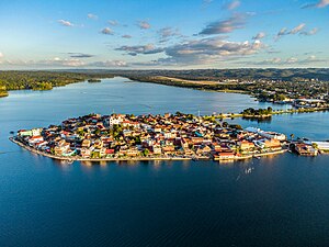
Flores, Petén
Place in El Petén, Guatemala
Distance: Approx. 976 meters
Latitude and longitude: 16.92972222,-89.89166667
Flores is the capital of the Petén Department, Guatemala's landlocked, northernmost department. The population was 45,560 in 2023. Flores is the seat of the municipality of Flores (population 22,600).
Tayasal (archaeological site)
Distance: Approx. 1241 meters
Latitude and longitude: 16.940251,-89.892413
Tayasal is a Maya archaeological site located in present-day Guatemala. It was a large Maya city with a long history of occupation. Tayasal is a corruption of Tah Itza ("Place of the Itza"), a term originally used to refer to the core of the Itza territory in Petén.
San Andrés, Petén
Municipality in El Petén, Guatemala
Distance: Approx. 4769 meters
Latitude and longitude: 16.9675,-89.91027778
San Andrés is a municipality in the department of El Petén in Guatemala. The municipality is formed by the town of San Andrés, located on the north-western shore of Lake Petén Itzá, and 55 rural communities, with a total population of 20,295 people (census 2002). The municipality was created in 1962 and has a territory 8,874 km2, equivalent to 25% of the department of El Petén.

San Benito, Petén
Place in El Petén, Guatemala
Distance: Approx. 2567 meters
Latitude and longitude: 16.91666667,-89.9
San Benito is a municipality in the El Petén department of Guatemala. It covers an area of 112 km2, and had 29,926 inhabitants at the 2002 Census; the latest official estimate (as at mid 2012) was 59,486 people. It is located adjacent to departmental capital Flores.
San José, Petén
Place in El Petén, Guatemala
Distance: Approx. 5911 meters
Latitude and longitude: 16.983625,-89.90099722
San José is a municipality in the Petén Department of Guatemala. It contains 3,602 people. It lies on the north shore of Lake Petén Itzá and is located a few kilometers from the Classic Period Maya ruin of Motul de San José.

Mundo Maya International Airport
Airport in Flores, Guatemala
Distance: Approx. 2813 meters
Latitude and longitude: 16.91388889,-89.86638889
Mundo Maya International Airport (Spanish: Aeropuerto Internacional Mundo Maya, IATA: FRS, ICAO: MGMM), formerly Flores International Airport as indicated by its IATA code, is an international airport located in the suburb of Santa Elena, in the city of Flores, Guatemala. It serves national and international air traffic for the areas of Flores, Santa Elena, and San Benito, as well as all the Maya sites of Tikal or Yaxhá and destinations such as Guatemala City and Belize. The airport lacks many amenities compared to other airports its size.
Santa Elena, El Petén
Distance: Approx. 2457 meters
Latitude and longitude: 16.917146,-89.899026
Santa Elena is located on the shores of Lake Petén Itzá in the Petén department of Guatemala. It is connected by a causeway to its sister town of Flores (the capital of the Petén department) and the two (together with San Benito) are often referred to as just Flores. It is the location for Mundo Maya International Airport, which is located just outside the town.
Petén Basin
Geographical region of Mesoamerica
Distance: Approx. 4112 meters
Latitude and longitude: 16.9,-89.9
The Petén Basin is a geographical subregion of the Maya Lowlands, primarily located in northern Guatemala within the Department of El Petén, and into the state of Campeche in southeastern Mexico. During the Late Preclassic and Classic periods of pre-Columbian Mesoamerican chronology many major centers of the Maya civilization flourished, such as Tikal and Calakmul. A distinctive Petén-style of Maya architecture and inscriptions arose.

Estadio Julián Tesucún
Multi-use stadium in San José, Guatemala
Distance: Approx. 5842 meters
Latitude and longitude: 16.98194444,-89.90388889
Estadio Julián Tesucún is a multi-use stadium in San José, Guatemala. It is currently used mostly for football matches, on club level by Heredia Jaguares de Peten of the Liga Nacional de Fútbol de Guatemala. The stadium has a capacity of 8,000 spectators.

Nojpetén
Capital city of the Mayan kingdom of Petén Itzá; now Flores, Guatemala
Distance: Approx. 976 meters
Latitude and longitude: 16.92972222,-89.89166667
Nojpetén (also spelled Noh Petén, and also known as Tayasal) was the capital city of the Itza Maya kingdom of Petén Itzá. It was located on an island in Lake Petén Itzá in the modern department of Petén in northern Guatemala. The island is now occupied by the modern town of Flores, the capital of the Petén department, and has had uninterrupted occupation since pre-Columbian times.
Nixtun Chʼichʼ
Itza Maya archaeological site in Guatemala
Distance: Approx. 5337 meters
Latitude and longitude: 16.948,-89.931
Nixtun-Chʼichʼ is an Itza Maya archaeological site in Petén Department, Guatemala. It has an urban grid with fairly well ordered streets and avenues dated to around 2500 years ago. This is one of the earliest urban grids in the Americas and likely emerged as the ancient Maya developed more complex forms of political organization.
Weather in this IP's area
scattered clouds
18 Celsius
19 Celsius
18 Celsius
18 Celsius
1017 hPa
98 %
1017 hPa
994 hPa
10000 meters
0.8 m/s
0.74 m/s
47 degree
30 %

