181.115.166.100 - IP Lookup: Free IP Address Lookup, Postal Code Lookup, IP Location Lookup, IP ASN, Public IP
Country:
Region:
City:
Location:
Time Zone:
Postal Code:
ISP:
ASN:
language:
User-Agent:
Proxy IP:
Blacklist:
IP information under different IP Channel
ip-api
Country
Region
City
ASN
Time Zone
ISP
Blacklist
Proxy
Latitude
Longitude
Postal
Route
db-ip
Country
Region
City
ASN
Time Zone
ISP
Blacklist
Proxy
Latitude
Longitude
Postal
Route
IPinfo
Country
Region
City
ASN
Time Zone
ISP
Blacklist
Proxy
Latitude
Longitude
Postal
Route
IP2Location
181.115.166.100Country
Region
cochabamba
City
sipe sipe
Time Zone
America/La_Paz
ISP
Language
User-Agent
Latitude
Longitude
Postal
ipdata
Country
Region
City
ASN
Time Zone
ISP
Blacklist
Proxy
Latitude
Longitude
Postal
Route
Popular places and events near this IP address

Battle of Viluma
1815 battle in Upper Peru, South America
Distance: Approx. 3830 meters
Latitude and longitude: -17.45612778,-66.34780833
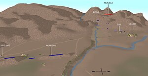
The Battle of Viluma, also known as Battle of Sipe-Sipe, was a major battle in the South American wars of independence in which the United Provinces of the Río de la Plata (formerly the Spanish Viceroyalty of the Río de la Plata) were decisively defeated in Upper Peru (now Bolivia) by the Royal Army of Viceroyalty of Peru. The battle took place on November 29, 1815 on a plain west of Cochabamba, and resulted in the loss of Upper Peru for Buenos Aires. The area was reannexed by the Spanish Viceroyalty of Peru.
Sipe Sipe Municipality
Municipality in Cochabamba Department, Bolivia
Distance: Approx. 5126 meters
Latitude and longitude: -17.48333333,-66.35
Sipe Sipe Municipality is the second municipal section of the Quillacollo Province in the Cochabamba Department, Bolivia. Its seat is Sipe Sipe. At the time of census 2001 the municipality had 31,337 inhabitants.
Vinto Municipality
Municipality in Cochabamba Department, Bolivia
Distance: Approx. 9439 meters
Latitude and longitude: -17.3667,-66.3667
Vinto Municipality is the fourth municipal section of the Quillacollo Province in the Cochabamba Department, Bolivia. Its seat is Vinto.
Sipe Sipe
Town in Cochabamba Department, Bolivia
Distance: Approx. 4 meters
Latitude and longitude: -17.45,-66.38333333
Sipe Sipe is a location in the Cochabamba Department in central Bolivia. It is the seat of the Sipe Sipe Municipality, the second municipal section of the Quillacollo Province.
Inka Raqay, Bolivia
Archaeological site in the Cochabamba Department, Bolivia
Distance: Approx. 3221 meters
Latitude and longitude: -17.47888889,-66.385
Inka Raqay (Quechua Inka Inca, raqay ruin, a demolished building; shed, storehouse or dormitory for the laborers of a farm; a generally old building without roof, only with walls) is an archaeological site in Bolivia. It is located in the Cochabamba Department, Quillacollo Province, Sipe Sipe Municipality, near the community of Linku. Inka Raqay was declared a National Archaeological Monument by Law No.
Inka Laqaya (Cochabamba)
Mountain in Bolivia
Distance: Approx. 3799 meters
Latitude and longitude: -17.48388889,-66.3875
Inka Laqaya (Aymara Inka Inca, laqaya ruins of a building, also spelled Inca Racaya, Inca Lacaya) is a mountain in the Bolivian Andes which reaches a height of approximately 3,280 m (10,760 ft). It is located in the Cochabamba Department, Quillacollo Province, Sipe Sipe Municipality, southwest of Sipe Sipe.
Ch'uñawi (Cochabamba)
Mountain in Bolivia
Distance: Approx. 7529 meters
Latitude and longitude: -17.43027778,-66.45111111
Ch'uñawi (Aymara for a place where potatoes are spread as part of the procedure to prepare ch'uñu, also spelled Chunahui, Chuñahui) is a mountain in the Bolivian Andes which reaches a height of approximately 3,700 m (12,100 ft). It is located in the Cochabamba Department, Quillacollo Province, Sipe Sipe Municipality. Ch'uñawi lies southeast of Tikrasqa.
Q'ara Apachita (Quillacollo)
Mountain in Bolivia
Distance: Approx. 9001 meters
Latitude and longitude: -17.40222222,-66.45166667
Q'ara Apachita (Aymara q'ara bare, bald, apachita the place of transit of an important pass in the principal routes of the Andes; name in the Andes for a stone cairn, a little pile of rocks built along the trail in the high mountains, "bare apachita", also spelled Khara Apacheta) is a 4,046-metre-high (13,274 ft) mountain in the Bolivian Andes. It is located in the Cochabamba Department, Quillacollo Province, Sipe Sipe Municipality.
Atuq Wachana (Quillacollo)
Mountain in Bolivia
Distance: Approx. 9215 meters
Latitude and longitude: -17.47638889,-66.46555556
Atuq Wachana (Quechua atuq fox, wacha birth, to give birth, -na a suffix, 'where the fox is born', also spelled Atoj Huachana) is a mountain in the Bolivian Andes which reaches a height of approximately 3,700 m (12,100 ft). It is located in the Cochabamba Department, at the border of the Quillacollo Province, Sipe Sipe Municipality, and the Tapacarí Province. Atuq Wachana lies southeast of Pichaqani.
Wisk'achani (Quillacollo)
Mountain in Bolivia
Distance: Approx. 4543 meters
Latitude and longitude: -17.48055556,-66.41166667
Wisk'achani (Aymara wisk'acha a rodent,-ni a suffix, "the one with the viscacha", also spelled Viscachani) is a 3,611-metre-high (11,847 ft) mountain in the Bolivian Andes. It is located in the Cochabamba Department, Quillacollo Province, Sipe Sipe Municipality. Wisk'achani lies northwest of Inka Laqaya.
Yuraq Yaku (Bolivia)
Mountain in Bolivia
Distance: Approx. 5634 meters
Latitude and longitude: -17.50027778,-66.37722222
Yuraq Yaku (Quechua yuraq white, yaku water, "white water", also spelled Yuraj Yaco) is a 3,232-metre-high (10,604 ft) mountain in the Bolivian Andes. It is located in the Cochabamba Department, Quillacollo Province, Sipe Sipe Municipality. Yuraq Yaku lies southeast of Inka Laqaya.
John XXIII College, Cochabamba
Private secondary school in Cochabamba, Cercado, Bolivia
Distance: Approx. 5257 meters
Latitude and longitude: -17.47555556,-66.34166667
John XXIII College (Spanish: Colegio Juan XXIII) is a private Catholic secondary school, located in Cochabamba, Cercado, Bolivia. The school was founded by Fr. Enrique Conraets in 1964 in La Paz, and follows a work-study model.
Weather in this IP's area
few clouds
22 Celsius
21 Celsius
22 Celsius
22 Celsius
1006 hPa
37 %
1006 hPa
700 hPa
10000 meters
2.68 m/s
2.45 m/s
94 degree
19 %
