181.115.143.180 - IP Lookup: Free IP Address Lookup, Postal Code Lookup, IP Location Lookup, IP ASN, Public IP
Country:
Region:
City:
Location:
Time Zone:
Postal Code:
ISP:
ASN:
language:
User-Agent:
Proxy IP:
Blacklist:
IP information under different IP Channel
ip-api
Country
Region
City
ASN
Time Zone
ISP
Blacklist
Proxy
Latitude
Longitude
Postal
Route
db-ip
Country
Region
City
ASN
Time Zone
ISP
Blacklist
Proxy
Latitude
Longitude
Postal
Route
IPinfo
Country
Region
City
ASN
Time Zone
ISP
Blacklist
Proxy
Latitude
Longitude
Postal
Route
IP2Location
181.115.143.180Country
Region
la paz
City
tiahuanaco
Time Zone
ISP
Language
User-Agent
Latitude
Longitude
Postal
ipdata
Country
Region
City
ASN
Time Zone
ISP
Blacklist
Proxy
Latitude
Longitude
Postal
Route
Popular places and events near this IP address

Tiwanaku
Archaeological site in Bolivia
Distance: Approx. 2894 meters
Latitude and longitude: -16.55472222,-68.67333333
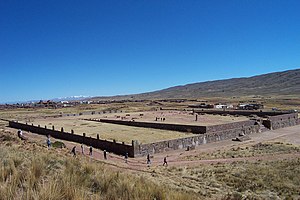
Tiwanaku (Spanish: Tiahuanaco or Tiahuanacu) is a Pre-Columbian archaeological site in western Bolivia, near Lake Titicaca, about 70 kilometers from La Paz, and it is one of the largest sites in South America. Surface remains currently cover around 4 square kilometers and include decorated ceramics, monumental structures, and megalithic blocks. It has been conservatively estimated that the site was inhabited by 10,000 to 20,000 people in AD 800.

Gate of the Sun
Bolivian monolith
Distance: Approx. 2807 meters
Latitude and longitude: -16.5544,-68.6741
The Gate of the Sun, also known as the Gateway of the Sun (in older literature simply called "(great) monolithic Gateway of Ak-kapana", is a monolithic gateway at the site of Tiahuanaco by the Tiwanaku culture, an Andean civilization of Bolivia that thrived around Lake Titicaca in the Andes of western South America around 500-950 AD. Tiwanaku is located near Lake Titicaca at about 12,549.2 ft (3,825.0 m) above sea level near La Paz, Bolivia. The Gate of the Sun is approximately 9.8 ft (3.0 m) tall and 13 ft (4.0 m) wide, and was carved from a single piece of stone. Its weight is estimated to be 10 tons.

Kalasasaya
Archaeological site in Bolivia
Distance: Approx. 2872 meters
Latitude and longitude: -16.555,-68.6736
The Kalasasaya (also: Kalassasaya; kala for stone; saya or sayasta for standing up) or Stopped Stones is a major archaeological structure that is part of Tiwanaku, an ancient archeological complex in the Andes of western Bolivia that is designated as a UNESCO World Heritage Site. The Kalasasaya is a low platform mound with a large courtyard, which is surrounded by high stone walls. The Kalasasaya is about 120 by 130 meters in dimension and aligned to the cardinal directions.
Pumapunku
Terraced platform mound in Bolivia
Distance: Approx. 2506 meters
Latitude and longitude: -16.56169,-68.67993
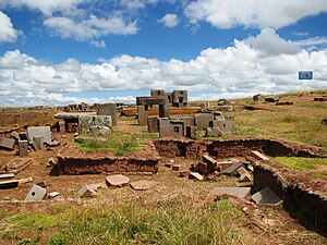
Pumapunku or Puma Punku (Aymara and Quechua 'Gate of the Puma') is a 6th-century T-shaped and strategically aligned man-made terraced platform mound with a sunken court and monumental structure on top. It is part of the Pumapunku complex, at the Tiwanaku Site near Tiwanacu, in western Bolivia. The Pumapunku complex is a collection of plazas and ramps centered on the Pumapunku platform mound.

Tiwanaku Municipality
Municipality in La Paz Department, Bolivia
Distance: Approx. 5140 meters
Latitude and longitude: -16.58333333,-68.66666667
Tiwanaku Municipality is the third municipal section of the Ingavi Province in the La Paz Department, Bolivia. Its seat is the village of Tiwanaku located near the UNESCO World Heritage Site Tiwanaku.
Tiwanaku, La Paz
Town in La Paz Department, Bolivia
Distance: Approx. 0 meters
Latitude and longitude: -16.55,-68.7
Tiwanaku is a village in the La Paz Department, Bolivia, with a population of 860 people. Towards the south of the village, there is the archaeological site of Tiwanaku.
Pukara (Guaqui)
Mountain in Bolivia
Distance: Approx. 9311 meters
Latitude and longitude: -16.61361111,-68.75666667
Pukara (Aymara for fortress, Hispanicized spelling Pucara) is a 4,119-metre-high (13,514 ft) mountain in the Chilla-Kimsa Chata mountain range in the Andes of Bolivia. It is situated in the La Paz Department, Ingavi Province, Guaqui Municipality. The Chilla River flows along its western slope.
Ch'alla Jawira (Ingavi)
River in Bolivia
Distance: Approx. 1211 meters
Latitude and longitude: -16.54777778,-68.68888889
The Ch'alla Jawira (Aymara ch'alla sand, jawira river, "sand river", also spelled Challa Jahuira) is a river in the La Paz Department in Bolivia. It is a left tributary of the Tiwanaku River which empties into Wiñaymarka Lake, the southern part of Lake Titicaca. The Ch'alla Jawira originates from various intermittent streams of the Chilla-Kimsa Chata mountain range northeast, north and northwest of the peak of Kimsa Chata in the Ingavi Province, Tiwanaku Municipality.
Weather in this IP's area
broken clouds
15 Celsius
14 Celsius
15 Celsius
15 Celsius
1008 hPa
49 %
1008 hPa
631 hPa
10000 meters
3.49 m/s
3.17 m/s
5 degree
82 %

