Country:
Region:
City:
Latitude and Longitude:
Time Zone:
Postal Code:
IP information under different IP Channel
ip-api
Country
Region
City
ASN
Time Zone
ISP
Blacklist
Proxy
Latitude
Longitude
Postal
Route
Luminati
Country
Region
qld
City
brisbane
ASN
Time Zone
Australia/Brisbane
ISP
Over The Wire Pty Ltd
Latitude
Longitude
Postal
IPinfo
Country
Region
City
ASN
Time Zone
ISP
Blacklist
Proxy
Latitude
Longitude
Postal
Route
db-ip
Country
Region
City
ASN
Time Zone
ISP
Blacklist
Proxy
Latitude
Longitude
Postal
Route
ipdata
Country
Region
City
ASN
Time Zone
ISP
Blacklist
Proxy
Latitude
Longitude
Postal
Route
Popular places and events near this IP address

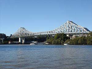
Story Bridge
Steel cantilever bridge in Brisbane, Queensland, Australia
Distance: Approx. 540 meters
Latitude and longitude: -27.4635,153.0358
The Story Bridge is a heritage-listed steel cantilever bridge spanning the Brisbane River that carries vehicular, bicycle and pedestrian traffic between the northern and the southern suburbs of Brisbane, Queensland, Australia. It is the longest cantilever bridge in Australia. The road across the bridge is named Bradfield Highway.

1974 Brisbane flood
Deadly flood in 1974 in Brisbane, Queensland, Australia
Distance: Approx. 510 meters
Latitude and longitude: -27.465,153.035
In January 1974 a flood occurred in Brisbane, Queensland, Australia after three weeks of continual rain. The Brisbane River, which runs through the heart of the city, broke its banks and flooded the surrounding areas. The cyclone that produced the flood also flooded surrounding cities: Ipswich, Beenleigh, and the Gold Coast.

Clem Jones Tunnel
Motorway tunnel in Brisbane
Distance: Approx. 576 meters
Latitude and longitude: -27.46343889,153.03536111
The M7 Clem Jones Tunnel (CLEM7), known during its development as the North–South Bypass Tunnel (NSBT), is a A$3.2 billion motorway grade toll road under the Brisbane River, between Woolloongabba and Bowen Hills in Brisbane, Queensland. The tunnel was progressively opened to traffic from late on 15 March 2010 until just after midnight on 16 March 2010. It was completely open by 12:02 am.

Howard Smith Wharves
Historic site in Queensland, Australia
Distance: Approx. 515 meters
Latitude and longitude: -27.463,153.0369
Howard Smith Wharves is a heritage-listed wharf on the Brisbane River beneath Bowen Terrace in Brisbane City and Fortitude Valley, Queensland, Australia. It was built from 1939 to 1942, and was known as Brisbane Central Wharves. The 3.5-hectare (8.6-acre) site is one of the most culturally and historically significant riverfront locations in Brisbane.

Yungaba Immigration Centre
Historic site in Queensland, Australia
Distance: Approx. 307 meters
Latitude and longitude: -27.4671,153.0366
Yungaba Immigration Centre is a heritage-listed former immigration hostel at 102 Main Street, Kangaroo Point, City of Brisbane, Queensland, Australia, alongside the Brisbane River. It was designed by John James Clark and built c. 1885 by William Peter Clark. It is also known as Yungaba Immigration Depot, Immigration Barracks, and No.6 Australian General Hospital.

Sunnyside, Kangaroo Point
Heritage listed building in Brisbane, Australia
Distance: Approx. 578 meters
Latitude and longitude: -27.47,153.035
Sunnyside is a heritage-listed detached house at 255 Main Street, Kangaroo Point, Queensland, Australia. It was built from c. 1895 to 1920s. It is also known as Dr Wright's House and was added to the Queensland Heritage Register on 28 July 2000.

Cairnsville
Historic site in Queensland, Australia
Distance: Approx. 338 meters
Latitude and longitude: -27.4639,153.0402
Cairnsville is a heritage-listed detached house at 41 Balfour Street, New Farm, City of Brisbane, Queensland, Australia. It was designed by Richard Gailey and built c. 1889 by Charles Le Brocq. It was added to the Queensland Heritage Register on 21 October 1992.
New Farm Cinemas
Historic site in Queensland, Australia
Distance: Approx. 363 meters
Latitude and longitude: -27.4649,153.0426
New Farm Cinemas is a cinema at 701 Brunswick Street, New Farm, City of Brisbane, Queensland, Australia. It was first built c. 1921. It is also known as Astor Theatre, Merthyr Picture Palace, and Village Twin Cinema Complex.

Bertholme
Historic site in Queensland, Australia
Distance: Approx. 89 meters
Latitude and longitude: -27.4664,153.0404
Bertholme is a heritage-listed detached house at 71–73 Moray Street, New Farm, City of Brisbane, Queensland, Australia. It was designed by Andrea Giovanni Stombuco and built from 1882 to 1883. It is also known as the Moreton Club.
Julius Street Flats
Historic site in Queensland, Australia
Distance: Approx. 190 meters
Latitude and longitude: -27.4683,153.0408
Julius Street Flats is a heritage-listed group of seven apartment blocks at 15 Julius Street, New Farm, City of Brisbane, Queensland, Australia. They were built from 1934 to early 1950s. The apartment blocks are called Ardrossan, Green Gables, Julius Lodge (formerly Nanmara), Syncarpia, Ainslie, Pine Lodge (formerly Aloha Court) and Evelyn Court.

Langshaw Marble Lime Works
Historic site in Queensland, Australia
Distance: Approx. 185 meters
Latitude and longitude: -27.4684,153.0405
Langshaw Marble Lime Works is a heritage-listed remains of a former lime kiln at 12 Julius Street, New Farm, City of Brisbane, Queensland, Australia. It was built from c. 1878 to c. 1881. It was added to the Queensland Heritage Register on 13 October 1997.

Feniton, New Farm
Historic site in Queensland, Australia
Distance: Approx. 344 meters
Latitude and longitude: -27.4659,153.043
Feniton is a heritage-listed villa at 388 Bowen Terrace, New Farm, City of Brisbane, Queensland, Australia. It was designed by Robin Dods and built from 1906 to 1907. It is also known as Almaden.
Weather in this IP's area
broken clouds
27 Celsius
27 Celsius
25 Celsius
28 Celsius
1013 hPa
78 %
1013 hPa
1011 hPa
10000 meters
3.09 m/s
30 degree
75 %
04:49:24
18:15:00