Country:
 Brazil
Region:
City:
Latitude and Longitude:
Time Zone:
Postal Code:
IP information under different IP Channel
ip-api
Country
Region
City
ASN
Time Zone
ISP
Blacklist
Proxy
Latitude
Longitude
Postal
Route
IPinfo
Country
Region
City
ASN
Time Zone
ISP
Blacklist
Proxy
Latitude
Longitude
Postal
Route
MaxMind
Country
Region
City
ASN
Time Zone
ISP
Blacklist
Proxy
Latitude
Longitude
Postal
Route
Luminati
Country
BRRegion
pr
ASN
Time Zone
America/Sao_Paulo
ISP
ITAIPU BINACIONAL
Latitude
Longitude
Postal
db-ip
Country
Region
City
ASN
Time Zone
ISP
Blacklist
Proxy
Latitude
Longitude
Postal
Route
ipdata
Country
Region
City
ASN
Time Zone
ISP
Blacklist
Proxy
Latitude
Longitude
Postal
Route
Popular places and events near this IP address

Ciudad del Este
City in Alto Paraná, Paraguay
Distance: Approx. 3141 meters
Latitude and longitude: -25.51666667,-54.61666667
Ciudad del Este (Spanish pronunciation: [sjuˈðað ðel ˈeste], Spanish for Eastern City; often shortened as CDE) is the second-largest city in Paraguay and capital of the Alto Paraná Department, situated on the Paraná River. It is located 327 km east of Asunción, the capital, and is adjacent to the border with Brazil, to which it is connected by the Friendship Bridge on the Paraná River. It is the largest city within the Triple Frontier region, which borders Foz do Iguaçu, Brazil and Puerto Iguazú, Argentina.
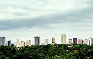
Foz do Iguaçu
Municipality in Sul, Brazil
Distance: Approx. 2647 meters
Latitude and longitude: -25.54,-54.5875
Foz do Iguaçu (Brazilian Portuguese pronunciation: [ˈfɔz du iɡwaˈsu]; "Iguazu River Mouth") is the Brazilian city on the border of Iguaçu Falls. The city is the 7th largest in the state of Paraná. The city's population is approximately 258,000.

Friendship Bridge (Brazil–Paraguay)
Bridge between Brazil and Paraguay
Distance: Approx. 1747 meters
Latitude and longitude: -25.50958333,-54.60111111
The Friendship Bridge (Spanish: Puente de la Amistad, Portuguese: Ponte da Amizade) is an arch bridge connecting the Brazilian city of Foz do Iguaçu and the Paraguayan city of Ciudad del Este.

Presidente Franco District
District and city in Alto Paraná, Paraguay
Distance: Approx. 3669 meters
Latitude and longitude: -25.53333333,-54.61666667
Presidente Franco (also simply known as Franco) is a district and city of the Alto Paraná Department, Paraguay. Aside from being the oldest city in Alto Paraná Department, it is a place of rich exports of fruits and vegetables. Also, Presidente Franco is well known for Saltos del Monday, a 45 m tall and 120 m wide waterfall, Eastern Paraguay.

Estadio Antonio Aranda
Distance: Approx. 2918 meters
Latitude and longitude: -25.52694444,-54.61194444
Estadio Antonio Aranda, known until 2013 as Estadio Tte. Cnel. Antonio Oddone Sarubbi, is a football stadium in the city of Ciudad del Este, Paraguay.

Roman Catholic Diocese of Foz do Iguaçu
Catholic ecclesiastical territory
Distance: Approx. 3410 meters
Latitude and longitude: -25.5469,-54.5869
The Roman Catholic Diocese of Foz do Iguaçu (Latin: Dioecesis Iguassuensis) is a diocese located in the city of Foz do Iguaçu in the ecclesiastical province of Cascavel in Brazil.

Roman Catholic Diocese of Ciudad del Este
Roman Catholic diocese in Paraguay
Distance: Approx. 2267 meters
Latitude and longitude: -25.5179,-54.6079
The Roman Catholic Diocese of Ciudad del Este (Latin: Dioecesis Urbis Orientalis) is a diocese of the Roman Catholic Church based in the city of Ciudad del Este, in the Ecclesiastical Province of Asunción in Paraguay.
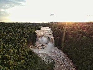
Saltos del Monday
Distance: Approx. 6867 meters
Latitude and longitude: -25.56194444,-54.63138889
The Municipal Park Monday [monˈdaɨ] and its main attraction – approximately 45 m (148 ft) tall and 120 m (390 ft) wide waterfall named Saltos del Monday – are located in the Presidente Franco District, Alto Paraná Department, Paraguay, located around 25°33'40.6"S latitude and 54°38'00.1"W longitude, occupying an area of 1.6 hectares (4 acres).

Federal University for Latin American Integration
Public federal university in Foz do Iguaçu, Paraná
Distance: Approx. 3277 meters
Latitude and longitude: -25.4946889,-54.5632553
The Federal University for Latin American Integration (Portuguese: Universidade Federal da Integração Latino-americana, UNILA) is a public university located in the Brazilian city of Foz do Iguaçu, Paraná, at the tri-national border shared by Brazil, Argentina and Paraguay. UNILA emphasises natural resources, social studies and language, international relations and areas considered important for development and regional integration. UNILA is a bilingual university, where Portuguese and Spanish are used.

Gran Ciudad del Este
Place in Paraguay ----
Distance: Approx. 2569 meters
Latitude and longitude: -25.51,-54.61
The Greater Ciudad del Este is a metropolitan area in Paraguay consisting of most of the Alto Paraná Department. It is the second-largest metropolitan area in Paraguay, after the Gran Asunción, and has more than 500,000 inhabitants. In Spanish, it is referred to by various terms, including the Gran Ciudad del Este, Area Metropolitana de Ciudad del Este, and Metro Ciudad del Este.

Mesquita Omar Ibn Al-Khatab
Mosque in Paraná, Brazil
Distance: Approx. 854 meters
Latitude and longitude: -25.52077778,-54.5785
The Omar Ibn Al-Khatab Mosque (Mesquita Foz Do Iguaçu) is a mosque located at Foz do Iguaçu, Paraná, Brazil. It is situated in the city near the Iguaçu Falls. The mosque was inaugurated on 23 March 1983 featuring a beautiful exterior design painted in uniform white color.

Cathedral of Saint Blaise
Church in Ciudad del Este, Paraguay
Distance: Approx. 2685 meters
Latitude and longitude: -25.50972,-54.61111
The Cathedral of Saint Blaise (Spanish: Catedral San Blas) is a Roman Catholic cathedral located in the city of Ciudad del Este, Paraguay. It is the seat of the Roman Catholic Diocese of Ciudad del Este. The cathedral is dedicated to Saint Blaise, the patron of the city and country.
Weather in this IP's area
clear sky
19 Celsius
19 Celsius
19 Celsius
19 Celsius
1020 hPa
72 %
1020 hPa
999 hPa
10000 meters
3.09 m/s
170 degree
06:34:05
18:32:12